

John1122
-
Posts
11,928 -
Joined
-
Last visited
Content Type
Profiles
Blogs
Forums
American Weather
Media Demo
Store
Gallery
Everything posted by John1122
-
 6-12 hours later it clears the Plateau and freezing rain to sleet happens there as moisture is pulling out Valentines day.
 -
0z GFS is further east with deeper cold vs 18z. Long duration freezing rain and sleet event unfolding mid state and west. Cold doggedly banks up against the Plateau and sits there.
-
The power of snow cover plus being surrounded by high ridges. It's 37+ even 10 miles away where the snow melted off today.
-
I'm honestly not sure where MRX sees the snow when all modeling suggests ice. They have low snow chances in my forecast several days in a row. Hope they are right.
-
This is a good illustration of the very consistently busted high temp forecasts in the area.
-
This is the 24 hour trend on the Euro for the ice coming in a couple of days, courtesy of Myfrotho.
-
Winter storm watches going up in Kentucky, I expect they may in West Tennessee and over to the Clarksville area as well. The RGEM/GGEM has ice storm warning criteria from the Plateau west in the d3 time frame.
-
The edge of the ZR shield in the Euro has moved south about 40 miles on 3 consecutive runs. I doubt it's done moving yet. That's happened in almost every event since Christmas.
-
This year models have struggled big time with the blocking to our north. They are apparently programmed to weigh the MJO heavily along with Nina/La Nina. But nothing affects our weather more than blocking in the regions closest to us. That's why the SE ridge is gone or pushed back once we get within 3 or 4 days this year. It also shows up in the cutters that end up being Miller As. We had a few of those this year that trended from Cutter to As. Even a Miller B or two modeled that ended up south of here. The cold was just on the other side of the world when they happened. That's why the higher elevations have done so well this year and it's been nickel and diming every one else. Now we have extreme cold lurking and a good possibility of a truly widespread winter weather event or even several. The precip hasn't shut down all year. The EURO and GFS about a week ago were giving .2 QPF for two weeks here but that fell apart quickly.
-
Euro/EPS look good for the cold arrival now. Has some suppressed activity then goes for an Apps runner late. Crazy 1050 high in SE Iowa at one point. All in all much colder than 24 hours ago. Just have to hope the timing and track improve. But getting cold is always the most important step.
-
0z RGEM is slowly sagging the cold into more and more of the forum. This starts in NW Tennessee around hr66.
-
Oz NAM shifted south towards the RGEM from 18z for the potential freezing rain event beginning in about 3 days for the western parts of the forum area.
-
Wintery precip is in the forum region at day 3 on that run.
-
There's a 33 degree difference between NW Tennessee and NE Tennessee the 16th. And it's 28 degrees in far NE Tn. That's just how cold the west side of the valley is at that time.
-
Theres tons of sleet on top of this for the western half of the forum region too. With snow inbound just after it. I don't have the sleet maps but it's a long duration heavy sleet event.
-
It goes out here frequently. I'm honestly surprised they got it fixed so quickly. Last heavy wet snow outage it was gone for 3 days.
-
They'll probably not change that and leave it as an AN day. I saw a story about snow measurements, someone at the obs site in one city didn't clear the snow board at all for 30 hours and recorded a measurements 8 inches less than surrounding sites. Another cleared it too frequently and recorded 4 inches more than any site around them. They lowered the extra 4 inches measurement by 6 inches and left the one that was 8 inches short alone. That's part of the reason yearly snow numbers are down so dramatically around the country. 1996 here is filled with missing data. It was one of the snowiest if not the snowiest year in Knoxville in the last 25 years. Same with Tri-Cities. Yet there's a ton of M for missing snow data in the record and official totals are less than half what actually fell that year.
-
Yes. It came back around 3, a tree was in the line about 1/2 mile up the mountain from here. Still a ton of outages in Campbell.
-
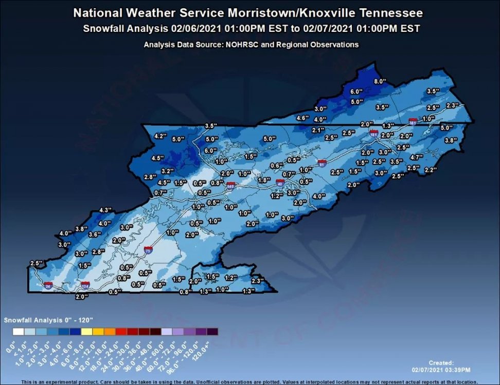
MRX map.
-
Took these around 2pm while waiting on my power to return.
-
Power finally came back. Will upload some winter wonderland photos shortly.
-
If it had been 28 we may have gotten 10+ and I'd have power and all my trees.
-
Typical post around here. This is one thing that happens when you get 6+ inches of heavy wet snow but forecasters down played it in a major way. "We weren’t prepared either. We didn’t even know it was supposed to snow. We have a fireplace for back up but we can’t get it out. My husband ran to town to get something to when it started just in case the power goes out again. Luckily I had just gotten groceries. We will have water since we have city water, but not hot water for a shower."
-
Still no power here. Broken trees in my yard. Lost a good sized piece of my favorite cherry tree.


