

Tyler Penland
-
Posts
2,245 -
Joined
-
Last visited
Content Type
Profiles
Blogs
Forums
American Weather
Media Demo
Store
Gallery
Posts posted by Tyler Penland
-
-
Got a few rogue flakes breaking through here south of Boone.
Temp is warmer than I expected at this point though currently 37.0/24.0
Sent from my Pixel 5 using Tapatalk -
Gotta go scrape the ice off my snow measuring board. Ha.We ready for whatever gents?
Don't know if it means much of anything but none of the models have that band developing over TN/AL. Mping reports show its reaching the ground in at least some spots too.
Sent from my Pixel 5 using Tapatalk
-
 2
2
-
-
I'm good with my driveway actually melting.Looks like a temporary break from the cold for a few days. But after that cutter it gets cold again.
This may be the longest I've had widespread multiple inches of snow (now ice) on the ground. Going on 2 weeks and should eclipse that easily.
Sent from my Pixel 5 using Tapatalk
-
1
-
-
Yeah unfortunately I just don't see it getting back this far. I certainly hope so but I'm very doubtful.Yep. All you gotta do is loop the H5 maps and see how this is trending. Also, the surface is under done even on that NAM run.
We should do well with the NWFS anyways. And I doubt this winter is over just yet.
Sent from my Pixel 5 using Tapatalk
-
1
-
-
Trend has been generally sharper/digging trough on the American models last couple days.
Would like to see the euro join in.
Sent from my Pixel 5 using Tapatalk-
1
-
-
GFS with a solid border county hit. Nearly a foot at elevation this run.
Sent from my Pixel 5 using Tapatalk-
2
-
-
I would think that regardless of phase location we'll see at minimum a nice NWFS event on the backside. Even the Euro wraps some moisture around and it's the latest phase of the globals right now.WPC updated 5 day graphic has introduced a snow chance for the Mountains..gif.764d26ed08c2aa0ce3d60dff8b319931.gif)
Sent from my Pixel 5 using Tapatalk
-
2
-
-
Looks like the weekend storm is coming back to us a bit.
Also Robert thinks we could see some elevation dependent snow tomorrow under the jet streak.-
1
-
-
Looks like a round of NWFS for the border counties overnight.
Won't amount to much but maybe another T-1" on top of the 6" of ice still in everybody's yard.
-
5
-
-
That's some serious convective feedback issues. It's been struggling with that a bit. That track would work out pretty well for the mountains. Would toss way more moisture back this way than that run showed.A track right over eastern NC would favor us big time. I was honestly shocked the run only dropped 7-10 inches here. A 970 low west of the OBX would be a mixed bag all the way to Burlington.
Sent from my Pixel 5 using Tapatalk
-
1
-
-
Ran into some flurries in Boone on the way home. Nothing of note though.
Sent from my Pixel 5 using Tapatalk-
1
-
-
GFS is storm after storm. Looks better for next Tuesday as well.
I'm very interested in next weekend, could be the next big one.
Sent from my Pixel 5 using Tapatalk-
2
-
-
Same around Boone. Saw one truck spun out in traffic coming into town.Roads are covered with a light dusting of snow here In Leicester. Looks like a dangerous commute around Asheville this morning.
Little slick out there.
Sent from my Pixel 5 using Tapatalk
-
1
-
-
RGEM looks nice. It has wavered a bit but been generally dead set on us getting a couple or 3 inches.
Sent from my Pixel 5 using Tapatalk-
2
-
-
Nice dusting on the ground here now.
0z HRRR with a big shift west with the precip shield. Develops an area of snow tomorrow afternoon that pushes east quickly.
Sent from my Pixel 5 using Tapatalk -
1 hour ago, Tacoma said:
It's never good when you click on the site and it's so quiet. I thought we might start seeing a little NW trend by now,
Meh let the eastern folks have their storm. We'll get ours. I'm still not convinced there's not a surprise tomorrow night/Friday.
Looks like a couple shots next week with plenty of waves coming down the line. We're running out of time a bit with the AO/NAO likely to really start hurting us soon but it's just January. Still got all of Feb/Mar and into April to go.
-
NAM showing those precip stripes at 12z.The devil is in the details with this one. Pull up a sounding, any sounding around WNC over the next 3 days and tell me that's not borderline snow. Skew-T says freezing drizzle best guess estimated precipitation with a column of air completely below freezing? Does the model not think the precipitation will push up into the dendritic growth area? Those 6000' peaks to Asheville's SW certain could help... Just because the precip maps and accumulation maps aren't showing the colors, doesn't mean that the atmosphere isn't ripe. Hell the 6z GFS has a snow sounding for tomorrow morning for most of you. The main takeaway is that the models are really struggling. They struggled like this in Dec 2017. That northern periphery of moisture was never really correctly modeled and finally it was assumed to be a nowcast event. I remember the GFS and Euro showing small stripes of snow over WNC and E TN a couple days out from the event and thinking they were warning shot. I think we are seeing something similar here, maybe on a less intense scale but today should be the day we see some type of movement in the models. I feel like we sit in a pretty good position.
Sent from my Pixel 5 using Tapatalk
-
1
-
-
19 minutes ago, WeatherHawk said:
How’s Foscoe?
It’s still coming down here atm.Tapered off to flurries around 4 or so and they're still flittering around. We don't usually do much with NWF. Just crazy windy still, even in our little wind hole here beneath Seven Devils.
Not sure exactly how much we wound up with because the wind blew it around but I measured between 9-11" in the yard with 15+" drifts.-
2
-
-
I vaguely remember back to back ice storms in January 2000 in GA when I was little. No clue what happened in NC or if they were actually back to back weekends or just really close together.I've lived in Cashiers and Glenville for the last 35 years and I can't remember a single time there were back-to-back weekends with big dog snowstorms. Has my memory just completely failed or is this truly anomalous?
Sent from my Pixel 6 Pro using Tapatalk
Sent from my Pixel 5 using Tapatalk
-
2
-
-
Don't look now, but the 18z GFS says we do this all over again next Sat/Sun. Nearly identical timing.
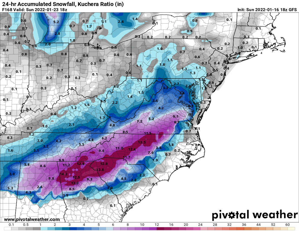
-
5
-
 1
1
-
-
Up to 8" and still steady snow. Keeps building in to my SW.
Took a walk down to 105 and I've seen it worse but wouldn't wanna try to climb the hill into Boone.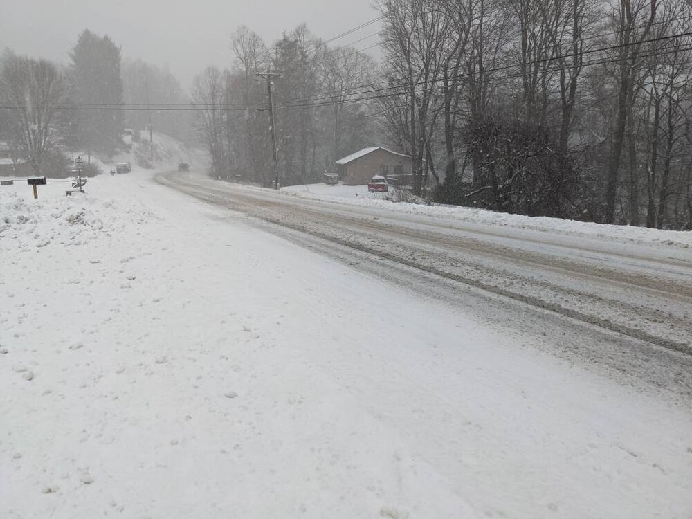
Sent from my Pixel 5 using Tapatalk-
3
-
-
Finally back to all snow and temps crashing. Ready for that banding to get here.
Sent from my Pixel 5 using Tapatalk-
1
-
-
Euro has this one too. 0z was a solid 6-8 for most of the state.Anyone ready to do this again next week? GFS did sniff today's out first...


Sent from my Pixel 5 using Tapatalk
-
1
-
-
Temp just hit 32. Didn't expect this at all.
Sent from my Pixel 5 using Tapatalk


2021-2022 Fall/Winter Mountains Thread
in Southeastern States
Posted
Coming down good on the Parkway above Linville. Visibility down to 3-400 yards if that.
Temp 28 up here.
Sent from my Pixel 5 using Tapatalk