

Tyler Penland
-
Posts
2,245 -
Joined
-
Last visited
Content Type
Profiles
Blogs
Forums
American Weather
Media Demo
Store
Gallery
Posts posted by Tyler Penland
-
-
Worth noting the NWFS on the backside looked better on this run of the GFS.
I think border areas over 5k easily get a foot. Gonna be wringing a lot of moisture out.
I'm also interested to see if this trends towards a temps-outrun-the-precip deal with a change to snow before the main frontal band actually moves out over the mountains. That cold push is SHARP.
Sent from my Pixel 5 using Tapatalk-
 2
2
-
-
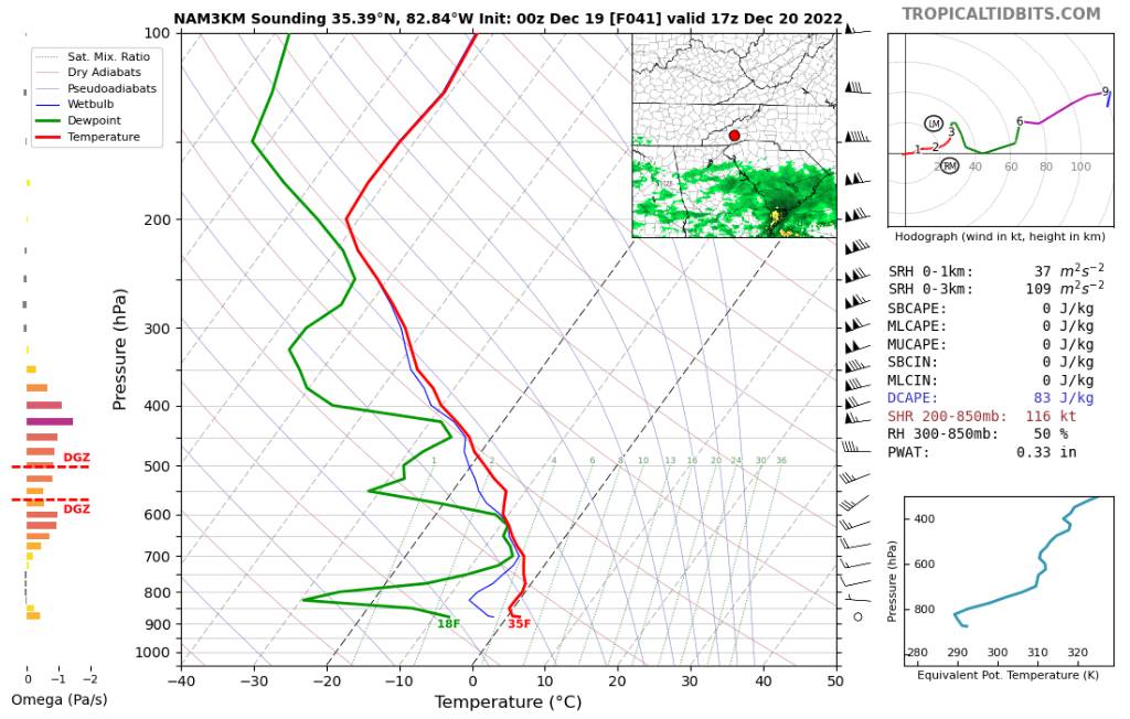
Yeah the 3k looks weird. Not sure why it isn't kicking more moisture up.NAM 3k is more suppressed with it's moisture. Suppressed?! Bullcrap! It'll come north.
Issue is a wicked dry slot in the mid levels but the 12km and 32km don't have that issue.
Sent from my Pixel 5 using Tapatalk
-
2
-
-
New NAM coming in drier. Still really really close.
Sent from my Pixel 5 using Tapatalk -
Classic case of globals severely underestimating the northern precip shield.Also don't look now but the nam is really wanting to do something with the system on the 20th. Giving several mountain counties some frozen precipitation even down into part of the foothills. This is kind of what im talking about sneaky little systems showing up in under 3 days...
Nothing has changed since 2014 with that trend. I wouldn't be surprised to see totals go up even more.
Sent from my Pixel 5 using Tapatalk
-
3
-
-
19 minutes ago, WxKnurd said:
Modeling aside, I’m with Hunter’s thinking that this Friday system isn’t gonna start to be cemented until Tuesday.
And the Sat/Sun system can very very easily trend in our favor as well.
-
5
-
-
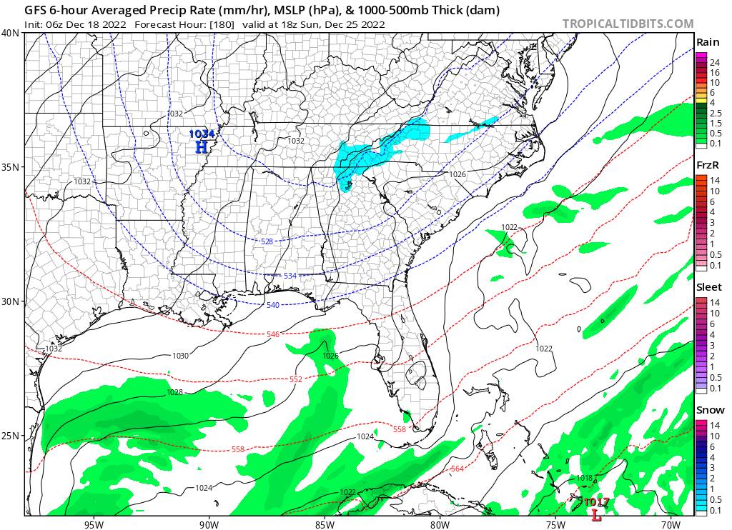
6z GFS another small improvement with this little wave on Christmas. It won't be much but could give a lot of the region some light snow on Christmas Day itself.
Edit: actually a significant improvement at 500.
Sent from my Pixel 5 using Tapatalk-
2
-
-
I've actually got some flurries right now.
Sent from my Pixel 5 using Tapatalk-
3
-
-
Yeah seems to have taken a tiny step in the right direction but I might be seeing things.Another decent hit for the mountains at 0z..
That next wave also has my attention for the 25/26. The 500mb charts look completely different for that one from 18z to 0z.
Sent from my Pixel 5 using Tapatalk
-
2
-
-
Even with these cutters the NW flow on the backside means business. Obviously not great the farther you get from the border but I think most everyone here would still do decent.
Sent from my Pixel 5 using Tapatalk-
5
-
-
I'm not sure how many times the Euro has to bury waves out west incorrectly before people realize it's really not that great at it, especially day 5-7.I’ll get toasted and roasted in the other thread if I say this, so I’ll say it here: the gfs is on an island but I couldn’t tell you the last time I saw the Euro have a correct solution at day 7 either. Last January’s storm, the gfs was completely on an island.
I swear 75% of the other thread just wants something negative to latch onto. I've peeked in there a couple times, that kind of roller coaster emotion would not be good for my health lol
Sent from my Pixel 5 using Tapatalk
-
3
-
 2
2
-
-
1 hour ago, Met1985 said:
Im leaving Christmas afternoon to go to Charleston
Not if some of these model runs have anything to say about it.
Nothing says crap roads like a foot of snow followed by multiple days well below freezing.
-
2
-
 2
2
-
-
Also seeing stations in Blowing Rock up towards Deep Gap falling towards freezing pretty quick. Several stations sitting at 32.7 right now.
Also of 2045 First stations around Aho just dropped below freezing.
Sent from my Pixel 5 using Tapatalk-
2
-
-
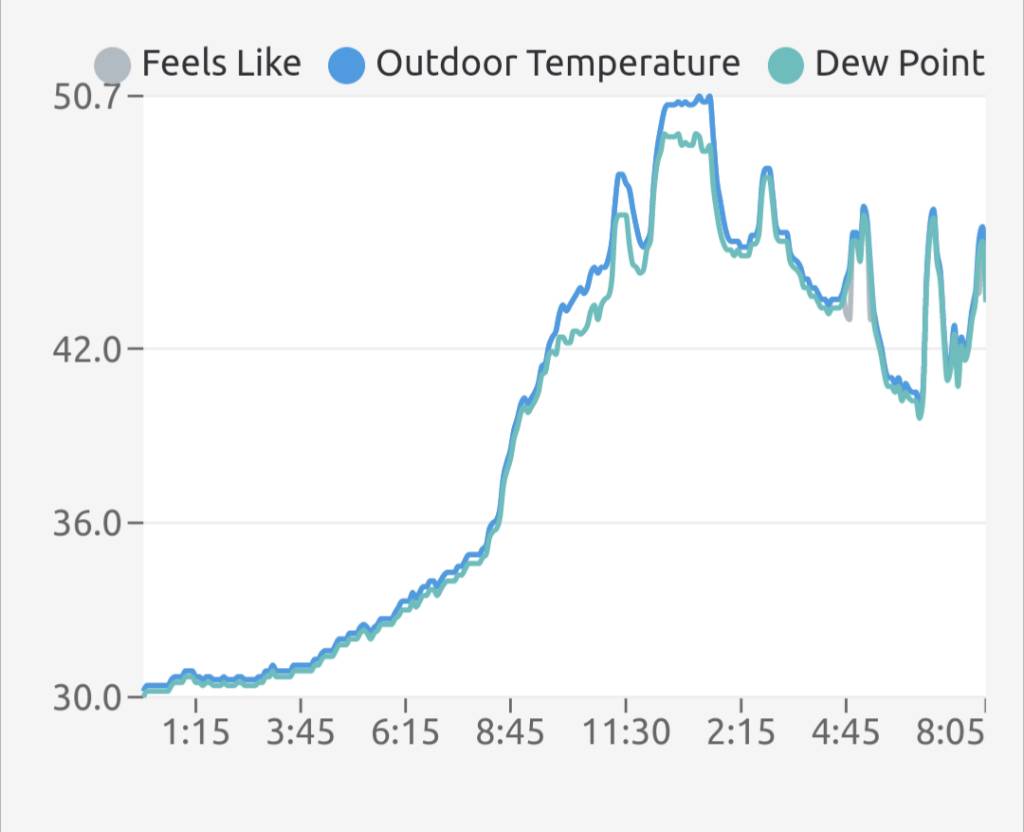
Watching the temperature swings during these wedge systems is fascinating. We sit right on the edge and have had the temp bouncing like a ball since mid afternoon.

Sent from my Pixel 5 using Tapatalk-
4
-
-
Also that's a crazy deep Christmas trough on the 18z GFS. Nearly sub-zero across the mountains.
-
2
-
-
RNK really downplaying any ice potential across NW NC and south/central VA tomorrow night. NAM is way overdone as usual but I have a hard time believing its going to bust that badly further north in areas where it shows predominately a snow/sleet event over a large part of VA. I guess we'll find out soon enough.
Regardless might be a slick commute in on Thursday morning along the NW escarpment.
-
2
-
-
Yeah I'm not completely ruling this out. It would definitely be a localized event but the 12km develops a weak surface low which is just enough to drag lower DPs in from VA. Could spell trouble from Blowing Rock up through Mt Airy during the morning commute Thursday.
Sent from my Pixel 5 using Tapatalk-
1
-
-
12km NAM is razor thin margins on ice in the northern foothills Wednesday night. Definitely not something to sleep on.
Sent from my Pixel 5 using Tapatalk-
1
-
-
Starting to get excited now. Gonna get the snow gear ready this week, hopefully I need it sooner rather than later.
Sent from my Pixel 5 using Tapatalk-
2
-
-
And the 0z is like "wat?"The 18z shows the potential of this upcoming pattern. I wouldn't get worked up about what you see but just know that this is a possibility especially after the 12th...
500mb looks way different than the last several runs.
Still a ways to go but I'm keeping my fingers crossed for some high elevation snow hiking on the 13th.
Sent from my Pixel 5 using Tapatalk
-
2
-
-
Assuming that blocking comes to pass. I'm hoping so but I'm not one to count unhatched chickens.Yeah temps are dropping. Diwn to 45 currently and windy. Going to be cold tonight. Probably some teens around. We will warm up the first of next week but it's all part of the plan. This blocking is very deep and extreme guys. We've not seen this in some 10 plus years...
Operational GFS has been hinting at the 11-13 time frame for a while now, though, so certainly something to watch.
-
2
-
-
Made it to 20.3 this morning.
Currently 29.1/26.0.
No interest in freezing rain, just bring me a cold rain. NAM/HRRR are very underwhelming for any impactful totals, especially the latest runs. I'm surprised the NWS has me getting up to an inch of snow, don't see that happening.
Sent from my Pixel 5 using Tapatalk-
2
-
-
Sugar opening tomorrow, app ski and Beech opening later in the week.
This cold snap is definitely good for business. I'm at Columbia in Blowing Rock peddling winter coats if anybody needs one.
Sent from my Pixel 5 using Tapatalk-
3
-
-
Final total of 7.54"
6.47" of that since midnight.
I'm good on rain for a bit.
Sent from my Pixel 5 using Tapatalk-
4
-
-
Just hit 7". Probably get to 8 easily looking downstream.
Road I live on is flooded for the first time I can remember.
Sent from my Pixel 5 using Tapatalk-
5
-
2022-2023 Fall/Winter Mountains Thread
in Southeastern States
Posted
Probably getting eaten up by the dry air. Currently 29/22.
Sent from my Pixel 5 using Tapatalk