

Tyler Penland
-
Posts
2,244 -
Joined
-
Last visited
Content Type
Profiles
Blogs
Forums
American Weather
Media Demo
Store
Gallery
Posts posted by Tyler Penland
-
-
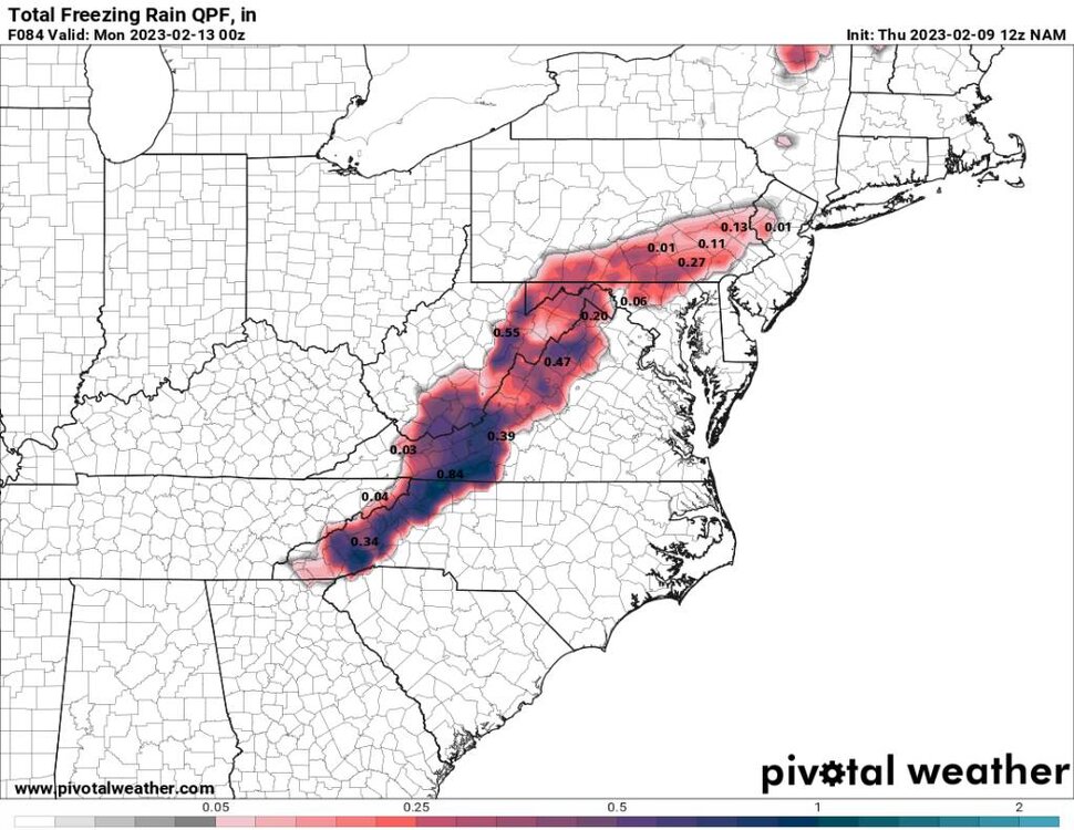
Unfortunately it's a ip/zr fest with only a bit of snow at the end.Also a reminder that the HRRR nailed that last synoptic event in Jan.-
 1
1
-
-
The ZR for the northern mountains showing up on the globals is concerning to me. I expect the NAM to show a lot of thst but globals on the other hand.
-
 1
1
-
-
12km a little colder this run though.More ZR on the NAM -
Can't blame them. Still 72 hours out with a ULL. Still plenty of time for something crazy to happen.Don't sweat it. They always come out the gate super slow.-
3
-
-
I'm heading to Charleston for work this weekend so I can pretty much guarantee a big mountain hit.
Trying to convince them to let me come down on Monday instead lol.-
 3
3
-
-
NAM is a ZR to rain to snow for most of WNC. .
-
18z euro was warmer aloft through 12z Sunday. Shifted everything west a little.
-
Euro looks very elevation dependent on the higher res maps. Showing a lot of mixing on Sunday afternoon.
-
1
-
-
RNK not buying it yet. Barely has any snow in my forecast so far. Guessing they'll bite if the 12z runs don't change.
-
Sheesh. Widespread double digits.
Thundersnow a good bet too this run verbatim.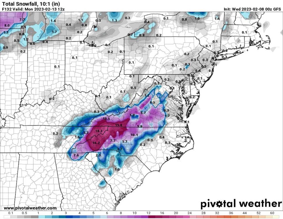
-
2
-
-
Temps are what scare me on this one. Look very borderline outside of 4kft+.
Of course if the GFS is correct it will fall quick enough it don't matter. -
Looking good for another solid NWFS event on the border next weekend. Euro and GFS have both been showing plenty of moisture.
Temps of all things might be an issue outside the highest elevations but if the trends continue definitely looks like possibly another foot above 5kft.-
2
-
-
15.1 for a low here this morning.
Brrr.-
2
-
-
Popped up to Roan today. Not a terribly large amount of snow, 3-4" on Roan High Knob and just a couple elsewhere for the most part. Even the rime ice melted off quick.
Still nice to get a snow hike in.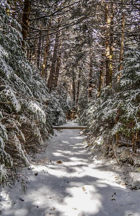
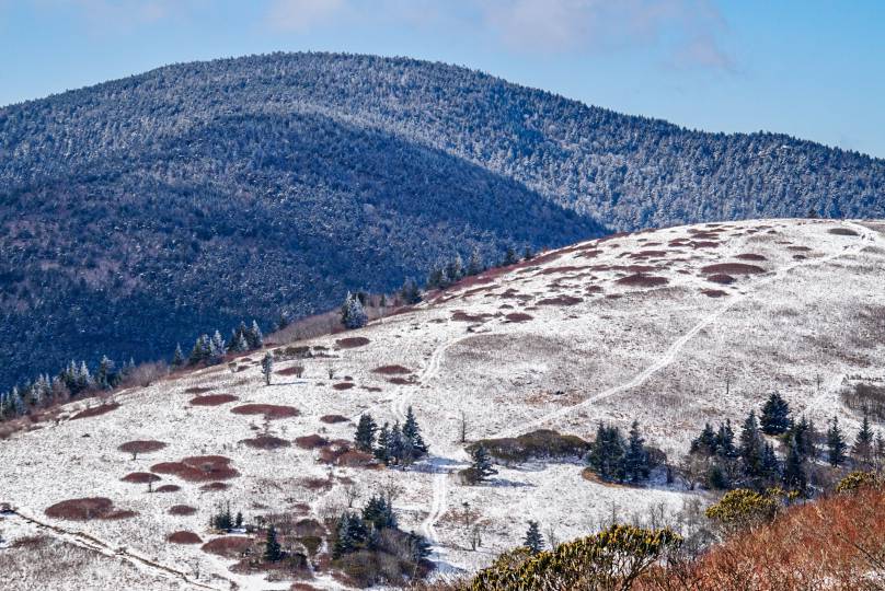
-
5
-
-
Got a few flurries here this morning.
Nice to finally feel like winter out if nothing else.-
3
-
-
It's been trying to mix in here at the house all morning. Mostly just a sleet/rain mix.
Edit: now some snowflakes finally. -
Solid dusting on the cams in Banner Elk.
-
2
-
-
The run for Boone since 2015 has been pretty crap outside of the 2018 storm which fell in an otherwise fairly unremarkable season.You could make a very convincing argument over the past decade that the worst location for snow in NC is the Lee/escarpment. It sounds asinine given the CAD potential and higher elevation but dang. Downsloped on flow and eastward tracking upper lows. And many storms phase too late for us to be part of the fun. 2018 was nice but holy cow I don’t remember a time where we’ve been in snow poverty worse than this stretch of years.
The airport has recorded only 0.5" through January 31 which as best I can tell has never happened before. 2020 was close with only an inch, but before that you have to go way back to find anything similar.-
1
-
-
If y'all south mountain folks cash in again while the northern are just dry I'm gonna move in with one of you.
-
3
-
-
The 3km took a big step backwards. Gonna be a fine line.00z nam. Pretty aggressive..thumb.jpg.dc454194ef211809e3f803d16bd24580.jpg)
Sent from my SM-G998U using Tapatalk -
Well looks like I might get a snow hike in finally.
Off on Friday, looks like I'll be heading up early to Roan Mountain.-
2
-
-
Another dusting here. I think that makes 5 or 6 snows of less than an inch this season.
I think I had more accumulation of limbs and sticks overnight. The difference in wind here at the house with W vs NW is wild. Not nearly as protected with W as NW. -
I like a more westerly flow here at the house. We tend to get down sloped a little bit less for some reason.The only caveat I see is the flow is more westerly this time. My area doesn't do as well typically in that setup.
Sent from my SM-S908U using Tapatalk-
2
-
-
I will gladly punt the rest of this winter if I don't have to see this piece of junk pattern again for another decade.The 18z gfs operation doesn't look good either. Doesn't really make a great push of cold air in here at all. The negative epo just dumps west and the SER flexes and the trough cuts north of us.-
2
-


.jpg.8bfe7f4d25a206ec1d20acbf65f0bef4.jpg)
2022-2023 Fall/Winter Mountains Thread
in Southeastern States
Posted
Can't really do what they do in upstate SC and issue only half the county because the higher elevations are scattered around everywhere and not just in one section.
It's a super common problem with FFC and the northern Georgia counties too.