

Tyler Penland
-
Posts
2,244 -
Joined
-
Last visited
Content Type
Profiles
Blogs
Forums
American Weather
Media Demo
Store
Gallery
Posts posted by Tyler Penland
-
-
Temp falling pretty quick down to 34.5 no precip yet.
Won't be wasting much on liquid it doesn't appear.
This assumes the upper temps catch up. Mesoanalysis has 850s back west of Morristown still.-
 3
3
-
-
Worth noting looking back towards Paris, TN the HRRR has been nearly spot on with the temperature drop.
NAM is running a little warm and the GFS and Euro even more so.
Sent from my Pixel 5 using Tapatalk-
3
-
-
Also don't know if this got mentioned but Beech is closed the next 2 days.
Last year it was too warm for Christmas, this year the opposite.
Sent from my Pixel 5 using Tapatalk-
2
-
-
I'm fascinated that there isn't even a WWA up here. Widespread black ice at the very least seems pretty likely if not guaranteed. That plus several inches of snow along the border you'd think would prompt one.
Sent from my Pixel 5 using Tapatalk-
1
-
-
This will be my first time seeing sub zero.Can't recall an afternoon temp below 10. Early 2000s remember it only got to 12 with a few inches snow on the ground.
I'm a bit excited about that, although I'm sure that will wear off quick. Lol
Sent from my Pixel 5 using Tapatalk
-
1
-
-
37.8 and creeping downward here south of Boone. Weirdly calm out there.
They hadn't touched the roads when I came home about 730. I think some secondaries had been done but none of the main roads yet.
Sent from my Pixel 5 using Tapatalk-
1
-
-
I am so jealous of you guys with those Elk. I wish it was feasible to introduce them back up here but far too many people.I had a visitor this afternoon while finishing up some preparations.
Sent from my Pixel 5 using Tapatalk
-
3
-
-
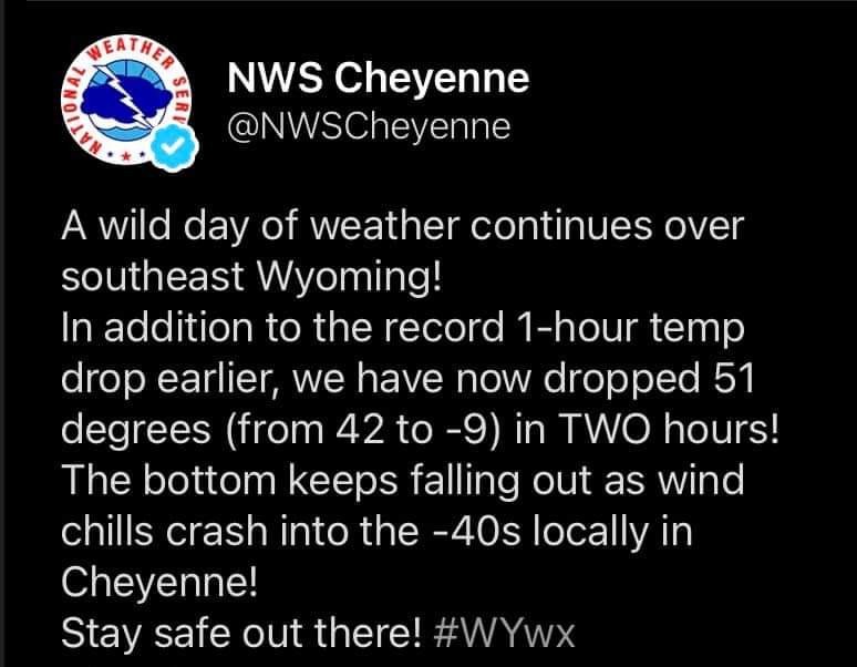
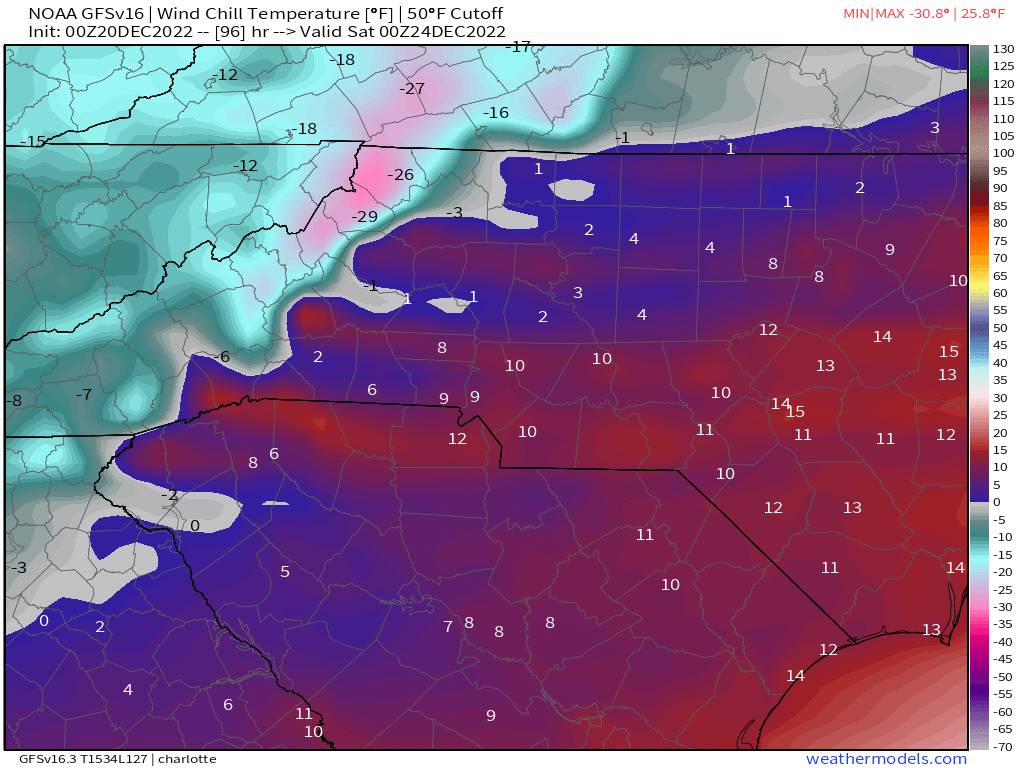
The almost definitely part is what concerns me.HRRR is almost definitely overdone but -20 to -30 wind chills are possible in Boone. Above 5K there could be -50 or worse. It will be interesting to see how low it goes compared to the guidance.
Probably overdone on temps but those kind of wind gusts aren't exactly unheard of. I believe the record is in the mid-70mph range. Even gusts of 60-65 would be problematic. Any power outages could be hard to reach with downed trees and a flash freeze.
Sent from my Pixel 5 using Tapatalk
-
18z HRRR has a minimum of - 14 in Boone.
-19 on Beech.
Max wind gust of 71MPH in Boone.
They've actually shut Beech down for the next 2 days due to the conditions.
Sent from my Pixel 5 using Tapatalk-
2
-
-
Well. That's concerning.The HRRR was too warm for Amarillo. HRRR suggested 7F and the actual temperature was -2F.
Sent from my Pixel 5 using Tapatalk
-
1
-
-
I wonder how the HRRR has been verifying out west. It keeps Boone below zero for over 24 hours with a low of -13 Saturday morning.Yes I've seen were the models have been severely behind on modeling the arctic front.
Sent from my Pixel 5 using Tapatalk
-
1
-
-
We had one for a while, didn't get back above freezing til a little before sunrise. Bypass area of Boone still had a decent glaze when I came through this morning at 9 as did a couple sections between Boone and BR.Anybody with a glaze? My DP rose quickly last night and stalled temps at 35.
Sent from my Pixel 5 using Tapatalk
-
1
-
-
She's a comin
Sent from my Pixel 5 using Tapatalk-
2
-
 1
1
-
-
Currently sitting at 32.9/21.3
Interesting night ahead with the ZR. Hopefully the roads are cleared up by the time folks get up.
Sent from my Pixel 5 using Tapatalk-
1
-
-
A 200 mile west shift at 5 days should almost be expected. Look what happened with the current system.The 18Z GFS has nothing wintry over the SE from either post frontal H5 disturbance. However, similar to the 12Z Euro, it does have from the 2nd disturbance a surface low that forms well offshore the SE coast. If there were to actually be a low that tracked, say, 200 miles west of that track, with about the same amount of cold air, there'd probably be a significant winter event 12/26-27 deep into the SE.
Keep in mind that this as well as the Euro low were generated by a disturbance currently 7,000 miles away from us and 4,000 miles off the Pacific NW coast where data is relatively limited and that isn't going to cross the Pacific coast for another 3 days. The pattern is quite complex with the huge Arctic high and another H5 disturbance ahead of this one by just one day. When considering all of this, a 200 mile west shift for something 5 days out isn't hard to fathom. So, though the odds favor no big deal 12/26-7 over the bulk of the SE from either disturbance based on model consensus continuing to keep it mainly quiet, a change to a big deal would not be the least bit shocking.
This could easily NW trend itself into a decent storm.
Or NW trend itself into a cutter.
Sent from my Pixel 5 using Tapatalk
-
2
-
-
Worth noting for the northern mountains at least the 3km NAM was a good improvement on snow. Basically no rain along the front just a snow squall.
Sent from my Pixel 5 using Tapatalk-
1
-
-
The HRRR is on drugs. Has Boone to -12 at the end of its run with a -39 wind chill.
Sent from my Pixel 5 using Tapatalk-
2
-
-
Yep pretty dry.NAM looks just like the euro in my opinion.
Looks like a decent amount of moisture at 850mb behind the front. Should keep the NWFS going for a little while.
Sent from my Pixel 5 using Tapatalk
-
2
-
-
Looking at the 3km NAM a quick change to snow with the actual frontal passage appears pretty likely. I'm concerned it'll be a bit moisture starved but ratios will go from 0-100 real quick.I thought the 18z looked good for snow in the mountains. Asheville is up to 2 inches on the model run. The temp drop is just going to be insane especially with the wind. That gfs run has Asheville at a min of 1 and has me at negative 5.... Yall seen today after tomorrow.... Yeah something like that lol.
Sent from my Pixel 5 using Tapatalk
-
2
-
-
New minimum for Boone on the 12z GFS is -7.
I'm curious to see if this verifies or not.
The Euro is about 10 degrees warmer.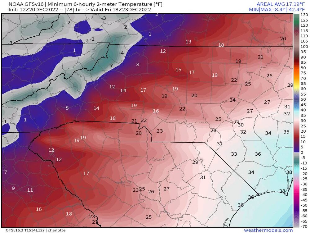
Sent from my Pixel 5 using Tapatalk-
4
-
-
Further to the above, the 12Z EPS shows a rather strong signal (much stronger than earlier runs) for a surface low offshore the SE at 162 (1 AM 12/27). Keep in mind that this is about a week out, which is still plenty of time for significant changes on the models:
[/img][/url]
The CMC has been harping on this for several runs now. It's the most amped and is mostly rain except some zr/ip in the mountains.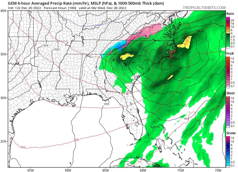
-
 1
1
-
-
With wind chills -20 to -30. Geez. Definitely time to put the flip flops away now.
Also, check out the 0z cmc for the 27th-28th. That time frame is looking more and more interesting. The gfs looked like it wanted to pop a low on the coast but never did. [
Sent from my SM-S908U using Tapatalk
The GFS has been trending in the right way for the past couple days. I think Met pointed out the CMC is actually beating the gfs/euro in the long range.
Here's hoping.
Sent from my Pixel 5 using Tapatalk
-
2
-
-
Coldest run of the GFS for Boone yet. From 33 to 1 from 6-12z Friday and down to -1 by afternoon. Bottoms out at -3.
Ive actually never seen below zero temps so that would be a first for me.
Brrrrrrrrrr
Sent from my Pixel 5 using Tapatalk
-
2
-
-
Negative. I peeked outside earlier to check when I seen them. Was hoping for flurries.[mention=3757]Tyler[/mention] Penland (and anyone else under those returns) are you seeing anything reaching the ground?
Sent from my SM-S908U using Tapatalk
Probably getting eaten up by the dry air. Currently 29/22.
Sent from my Pixel 5 using Tapatalk
-
1
-


2022-2023 Fall/Winter Mountains Thread
in Southeastern States
Posted
Sent from my Pixel 5 using Tapatalk