

Tyler Penland
-
Posts
2,245 -
Joined
-
Last visited
Content Type
Profiles
Blogs
Forums
American Weather
Media Demo
Store
Gallery
Posts posted by Tyler Penland
-
-
New 3km NAM looks good for the NW border counties, mainly above 3kft looks like and closer to the border is better.
Big improvement over 18z.
Sent from my Pixel 5 using Tapatalk-
 1
1
-
-
Sunday morning is going to be oh so close for those in Avery, Watauga and Ashe. GFS has a brief thump of snow on the front end but short range models are razor thin margins. Doesn't look like much either way but anything would be better than the 40 and rain that is otherwise forecast.
-
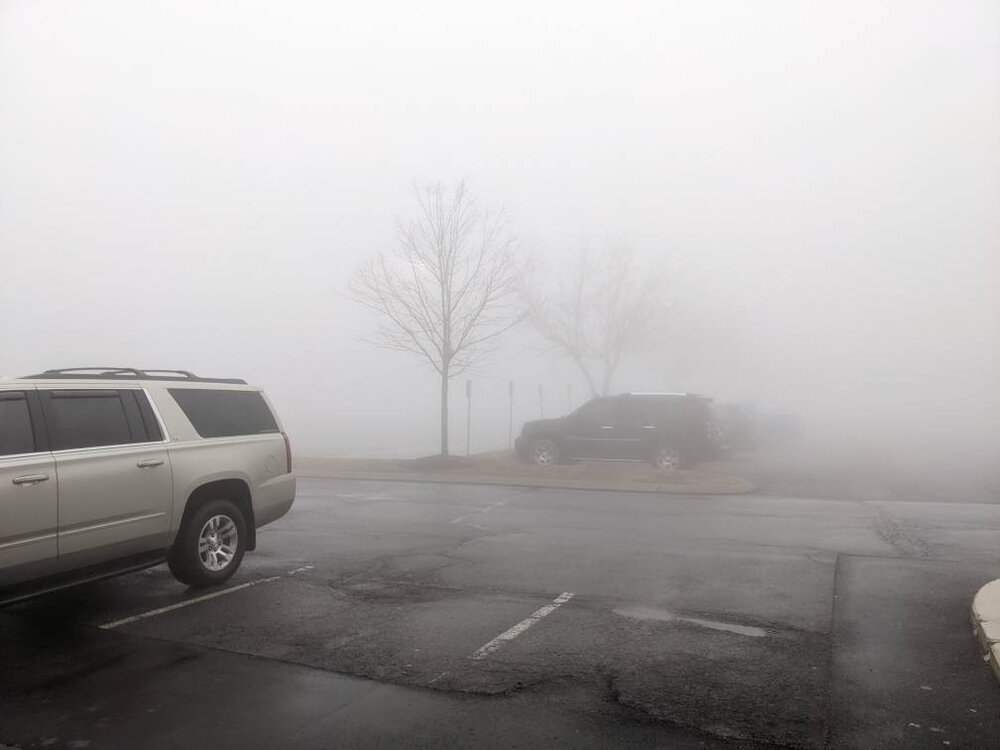
Yeah. I'm a manager at the Columbia Sportswear there. That kind of fog is really not good for business lol.is that tanger in blowing rock
Sent from my Pixel 5 using Tapatalk
-
1
-
-
The fog along the escarpment today was absolutely miserable. Thickest I've seen since we opened up the store in the outlets. Visibility dropped below 50 yards on and off all day.
Sent from my Pixel 5 using Tapatalk-
2
-
-
Sunday into Monday trending in a very interesting direction.
Sent from my Pixel 5 using Tapatalk-
2
-
-
Nice, man!
I'm pleasantly surprised how hard it's coming down at times. Wasn't quite sticking at the house when I left but temp was down to 33.
Sent from my Pixel 5 using Tapatalk-
1
-
-
Windy and warm out there tonight. Currently 56 here at the house. Eerie outside.
Sent from my Pixel 5 using Tapatalk -
Shhhhhhhhh.Mighty quite in here considering the chances for snow are trending better each day for snow Sunday morning in our area.
You'll scare it.
Sent from my Pixel 5 using Tapatalk
-
3
-
 3
3
-
-
RGEM: 1The RGEM is either the worst or best model at the moment. All on its own showing a zr/ip event for the foothills with a quick snow thump for the NW mountains Monday.
Rest of all guidance: 0
Sent from my Pixel 5 using Tapatalk
-
1
-
1
-
-
27 down here in Foscoe but no precip yet.30.9 with light rain. Everything elevated is coated! Sidewalks are also slick. Never underestimate CAD….
Saw there is a 20 car pileup being worked on 421. Currently no way up or down the mountain into Boone with 321, 221 and 181 also train wrecks.
Sent from my Pixel 5 using Tapatalk
-
2
-
-
27 here but no precip yet.
Deep Gap fire shut down 421 due a 20car pileup.
Sent from my Pixel 5 using Tapatalk -
The RGEM is either the worst or best model at the moment. All on its own showing a zr/ip event for the foothills with a quick snow thump for the NW mountains Monday.
-
1
-
-
Just enough to cover up all the dead grass and mud. Yard looks much better now. Ha.Yeah a nice little whitening of everything. Solid cold morning with a low of 16 here.
Sent from my Pixel 5 using Tapatalk
-
2
-
-
Snow flurries/showers all the way down into North Alabama this evening. Seeing some reports even into the north Atlanta suburbs.
Currently just half a dusting on the cars but hoping for a little more than that.
Sent from my Pixel 5 using Tapatalk-
1
-
-
Interested to see what we are able to squeeze out tomorrow night with any NWF. NAM/GFS both hinting at the potential for a dusting to top off the rain. Nothing big, though.
Euro/GFS both also showing potential for a light event along the border on Monday. Temps look sketchy, though.
-
Yeah it's had a decent run with these storms. It's 5 day verification scores have been suffering the last couple weeks, though. It also is a ways out of line from its own ensembles right now.GSP saying the GFS model showing cold and snow is an outlier. Wasn't the GFS the model that locked on to the last couple of storms? GSP still says that timeframe still needs watching.
Eventually one of these storms will amp up rather than slide off the coast.
Sent from my Pixel 5 using Tapatalk
-
Yeah it's on its own planet. Still got my fingers crossed.NWS says pretty much ignore GFS..take with a grain of salt
Sent from my Pixel 5 using Tapatalk
-
1
-
-
We have ourselves a storm to track.
Euro has been trending towards this GFS just decided to go all in.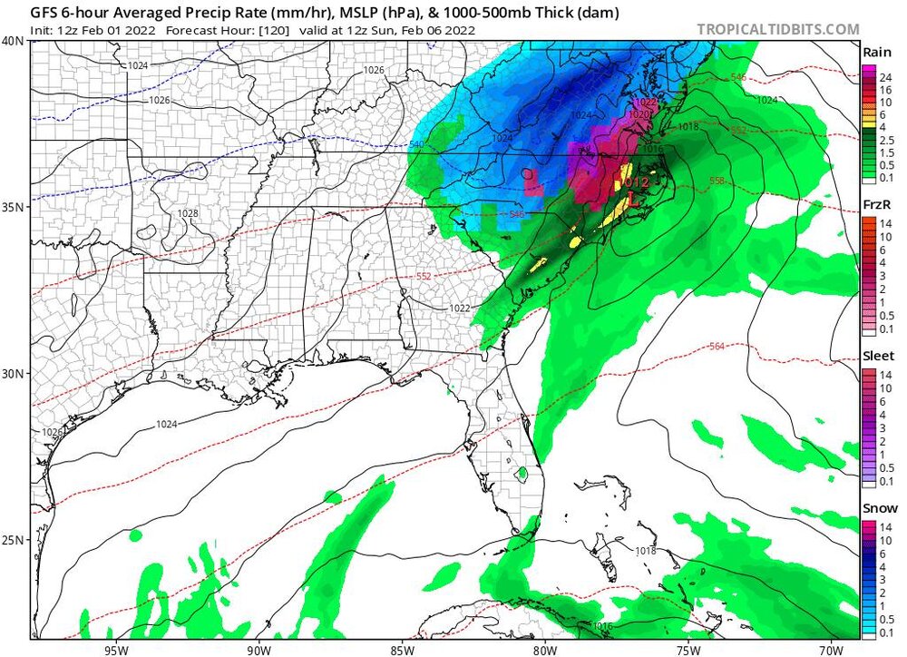
Sent from my Pixel 5 using Tapatalk-
5
-
-
Euro came in less surpressed. Actually love that look for day 5-7. Very nearly a classic Miller A.
Sent from my Pixel 5 using Tapatalk -
GFS is on an island with this one. Even it's own ensembles think it's crazy.Who's excited to track next week's ice storm? Haha!

Possible I guess but wanna see other guidance come in less suppressed.
Sent from my Pixel 5 using Tapatalk
-
1
-
-
12.0 at 7:46AM.
Stayed between 12 and 14 for almost 12 hours.
Sent from my Pixel 5 using Tapatalk-
1
-
-
The flow looked a little too N/S oriented for the NW mountains last night. We do better with a little more westward component.It looks like parts of Buncombe county got more than Banner Elk
Sent most of the moisture down towards Asheville.
Sent from my Pixel 5 using Tapatalk
-
Only about 1.5" here. We get down sloped pretty bad in this part of the county though.
Congrats to you SW guys!
Sent from my Pixel 5 using Tapatalk-
2
-
-
That might be the best looking NW flow radar I've ever seen since I moved up here in '15. Absolutely STACKED.
Sent from my Pixel 5 using Tapatalk-
4
-

2021-2022 Fall/Winter Mountains Thread
in Southeastern States
Posted
Sleeting this morning. Currently 32.5.
Sent from my Pixel 5 using Tapatalk