

Tyler Penland
-
Posts
2,247 -
Joined
-
Last visited
Content Type
Profiles
Blogs
Forums
American Weather
Media Demo
Store
Gallery
Posts posted by Tyler Penland
-
-
Temperature finally falling off a cliff here. Down from 41.7 to 36.8 since 4AM. Just a matter of time now.
-
 2
2
-
-
First potential thundersnow in Alabama.
Could be thundersleet. Tuscaloosa County right near the transition line.-
1
-
-
Avery, Watauga and Ashe look to do pretty well this time. Here's hoping.HRRR.thumb.png.5f155522d2bf552c5afcc2240d474661.png)

Sent from my Pixel 5 using Tapatalk
-
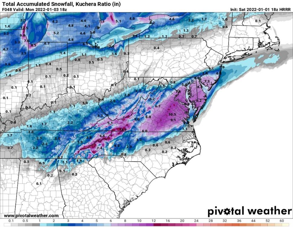
Also going to be a VERY sharp gradient in spots. From very little or nothing to 6-10" over a 15-20 mile span or less.Relatively speaking yes. Given the GFS depiction of rapid intensification, to elevation, to temps crashing and high winds this could be a real thing. Not to get into extremes but this would be a time when this would be an extreme local weather event if all unfolds as is being depicted.
Reminds me a LOT of Christmas Eve 2020
Sent from my Pixel 5 using Tapatalk
-
1
-
-
Nope but had some good undulating asperatus here in Blowing Rock.Anyone see the mammatus clouds this morning?
Sent from my Pixel 5 using Tapatalk
-
2
-
-
I'll be impressed if they have enough service to stream from up there. Gonna be crazy for sure.Two storm chasers locally will be camping out along Carver's Gap to live stream (hopefully) blizzard conditions. I wouldnt worry about their safety, these two know what they are doing.
Sent from my Pixel 5 using Tapatalk
-
Um. OK then.
Sent from my Pixel 5 using Tapatalk-
5
-
-
Maybe worth noting (or not it is the HRRR), but the HRRR is a really good hit for much of the entire state.
Sent from my Pixel 5 using Tapatalk-
1
-
-
Worth watching that Thursday night threat too. Temps look much better just need the moisture.
Sent from my Pixel 5 using Tapatalk-
4
-
-
RGEM/RDPS not buying the no moisture solution on the NAM either.
-
0z NAM has my attention.
Big shift south with the LP. Would be excellent for most of NC.
-
2
-
-
16 minutes ago, Met1985 said:
Also the 00z GFS still looks good for Sunday night.
Need that secondary LP to be just a tick farther south for us in the NW mountains.
-
1
-
-
I'll have whatever the 12z GFS is having. That secondary low development could be good for us if it happens.
Sent from my Pixel 5 using Tapatalk-
2
-
-
Meanwhile it's snowing in Seattle again.Yeah this pattern is not even close to normal. The whole SE weather has been spring like...
Sent from my Pixel 5 using Tapatalk
-
1
-
 1
1
-
-
Few flurries fluttering around the house this morning. Not a complete shutout for December.
Sent from my Pixel 5 using Tapatalk-
1
-
-
5 hours ago, Maggie Ace said:It never got above 44 at the house today after a morning low of 25. I'm slight intrigued with the NAM suggestion of moisture arriving tomorrow morning across portions of the Mountains.
If we could get the storm track as of late to shift west a bit we'd be in business. This is the 3rd or 4th slider that's stayed just too far south.
Haven't had a nice track since that storm first of November. -
Had quite a few wrecks around the county due to freeing fog this morning. Very unexpected.
Sent from my Pixel 5 using Tapatalk -
On 12/6/2021 at 11:21 AM, Buckethead said:The 12z gfs is looking nice for Sunday with 4-8" of snow in the border
Remember when it looked like we might get something besides rain and a brief cold shot?
Pepperidge Farms remembers.*sigh*
-
4 hours ago, Buckethead said:
My NWS forecast now has some sort of frozen precip for Monday night-Wednesday night. With the way the pattern has been I'll count just seeing a few wet flakes as a win.
Sent from my SM-G970U using Tapatalk
Yep MRX has sleet/snow here overnight Tuesday. Looking at GFS/NAM soundings it certainly looks... interesting. Probably wind up being a 33 degree rainstorm but one can dream I suppose.
-
1
-
-
Thankfully we've got Christmas cause we're sure not selling a bunch of winter coats right now.Yeah things are not looking good at all. A sharp rise in the NAO and a sharp fall in the PNA spells doom for this month already. The ski resorts are going to take a beating
On the bright side I can wear my Hawaiin shirts with my Santa hat and not look quite as crazy this year.
Sent from my Pixel 5 using Tapatalk
-
 2
2
-
-
Currently 55.4 at 9:30PM on December 2nd.
Bout time to move more north.
-
1
-
1
-
-
59 minutes ago, wncsnow said:
We also have a fire on Pogue mountain between Glenwood and Nebo south of I 40.
The upcoming Nina has me a bit worried. Looking pretty dry for at least the next week or two and I don't really see anything in the extended ensembles that look like that's gonna change.
-
Made it to 22 before the inversion broke and we rocketed from 22 to 38 from about 4-5AM.
Lots of wind with that change, too.
Sent from my Pixel 5 using Tapatalk-
1
-
-
Hope you folks had am excellent Thanksgiving!
I'll be heading in early to open the store up for Black Friday. Hoping I'm dodging flakes the whole way in.
Update: no snow yet. Was actually a quite balmy 38 at 0515. I could do without the 40-45MPH winds though.-
5
-
.png.c7cbcdd61b057ada32f482911351a27b.png)


2021-2022 Fall/Winter Mountains Thread
in Southeastern States
Posted
Right on time per our good friend the HRRR. Still waiting a bit south of you but webcam shows a changeover in Banner Elk. Can't tell about Boone for sure.