

Tyler Penland
-
Posts
2,387 -
Joined
-
Last visited
Content Type
Profiles
Blogs
Forums
American Weather
Media Demo
Store
Gallery
Posts posted by Tyler Penland
-
-
1 hour ago, Buckethead said:
Moderate snow and 31 this morning in Wolf. A car topper so far (10 minutes or so.)
Sent from my SM-G970U using Tapatalk
Seen a few flakes mixing in here a little bit ago. Actually had a light rain/sleet/snow mix going all at once for about 10 minutes.
Just April saying hello.-
 1
1
-
-
Check back early tomorrow morning. I'm betting you'll get a dusting. That spot over into Moses Cone/Flat Top usually does better than spots around in flow snow.Here for the weekend in Boone at 4k off poplar grove/Russ Cornett and I was going to say nothing here but I went to check the floods and there’s a stray flake (that’s being generous) so it’s a win.
That whole upper half of Shulls Mill didn't completely melt off in spots until a couple weeks ago.
-
We're at 38 with rain/pinger mix here IMBY. Should switch over soon.Currently 30 with light snow here in Wolf.
Sent from my SM-G970U using Tapatalk
Sent from my Pixel 5 using Tapatalk
-
2
-
-
Sitting at rhe bowling alley in Boone with occasional graupel and sunshine.
Drunk weather.
Sent from my Pixel 5 using Tapatalk-
2
-
-
These storms along the escarpment mean business. Absolutely dumping.
Sent from my Pixel 5 using Tapatalk -
Man congrats to you border and southern mountain folks. We managed an inch today with the snow squalls. Down to 13.5 and still very breezy. Not our storm again up here but still a refreshing break before spring gets here.
Sent from my Pixel 5 using Tapatalk-
3
-
-
Just had a squall run through Blowing Rock drop visibility down to 100 yards or so. Looked like fog. Wild. Lovin it.
Sent from my Pixel 5 using Tapatalk-
1
-
-
Wind is bonkers here in Blowing Rock. Ran into some low visibility snow on the way in around Valle Crucis. Actually some occasional sun over here on the escarpment right now.
Sent from my Pixel 5 using Tapatalk-
3
-
-
Just a thick dusting here south of Boone.
Ready for the NWFS to get going.
Sent from my Pixel 5 using Tapatalk-
2
-
-
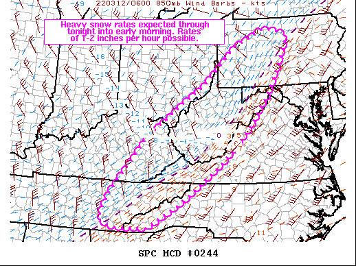
Areas affected...Portions of southern and central Appalachians and vicinity Concerning...Heavy snow Valid 120733Z - 121330Z SUMMARY...Heavy snow is possible within the southern and central Appalachians and vicinity. 1-2 inches per hour snowfall is possible in eastern Tennessee and Kentucky. Rates of 1-1.5 inches per hour will continue to move northeastward into West Virginia and western/central Pennsylvania towards early morning. DISCUSSION...Temperatures have been dropping quickly across eastern Tennessee and Kentucky over the past 1-2 hours as cold air advection and diabatic cooling have increased. Correlation coefficient data from KJKL and KMRX show a transition zone from rain to snow roughly located in the Cumberland Plateau vicinity. This transition zone has quickly shifted east over the last hour. The combination of mid-level ascent and upslope flow will support 1-2 inch snowfall rates along the western slopes into the Appalachians. The greatest snowfall rates will begin to taper off by 4-6 AM EST. Farther north, snowfall is increasing across West Virginia into western Pennsylvania. Several observations sites are reporting moderate to heavy snow that is has been primarily driven by 850-700 mb frontogentic lift. As the trough moves east and intensifies, deep-layer ascent will increase in these areas into early Saturday morning. The potential for 1-1.5 inch snowfall rates will increase accordingly during the next several hours. ..Wendt.. 03/12/2022
Sent from my Pixel 5 using Tapatalk-
1
-
-
30 with all snow. Not sticking yet but won't be long.
Edit: mixing with sleet at times.-
1
-
-
Same here. 48.6What's everyone's temp currently? Im sitting at 48 degrees.
Sent from my Pixel 5 using Tapatalk
-
1
-
-
12z HRRR tracks the LP right over CLT. Looks really good for the mountains this run with several hours of snow with the main band before NWF sets in.
Bring. It.
Also @BooneWXI'm sitting at a lovely 19". 100% of that fell in that 3 week period of January too.
-
2
-
-
GSP talking about convectively enhanced snow Saturday afternoon. Gonna be a fun day no doubt.
Sent from my Pixel 5 using Tapatalk-
3
-
-
Trends this whole season seem to have been towards more suppressed the closer we get. That could help in terms of accumulation this time if you are like me and wanna see one more good one.
Sent from my Pixel 5 using Tapatalk-
2
-
-
I'll have whatever the 12z GFS is having for next weekend.
Sent from my Pixel 5 using Tapatalk-
2
-
 1
1
-
-
Sleeting this morning. Currently 32.5.
Sent from my Pixel 5 using Tapatalk-
1
-
-
New 3km NAM looks good for the NW border counties, mainly above 3kft looks like and closer to the border is better.
Big improvement over 18z.
Sent from my Pixel 5 using Tapatalk-
1
-
-
Sunday morning is going to be oh so close for those in Avery, Watauga and Ashe. GFS has a brief thump of snow on the front end but short range models are razor thin margins. Doesn't look like much either way but anything would be better than the 40 and rain that is otherwise forecast.
-
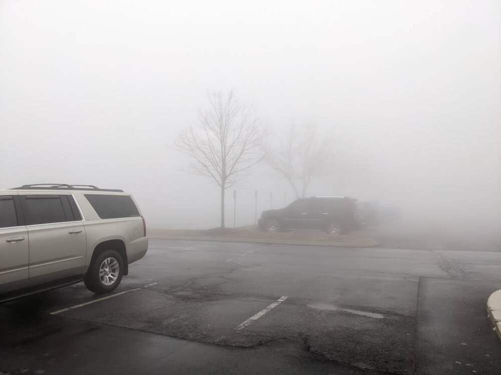
Yeah. I'm a manager at the Columbia Sportswear there. That kind of fog is really not good for business lol.is that tanger in blowing rock
Sent from my Pixel 5 using Tapatalk
-
1
-
-
The fog along the escarpment today was absolutely miserable. Thickest I've seen since we opened up the store in the outlets. Visibility dropped below 50 yards on and off all day.
Sent from my Pixel 5 using Tapatalk-
2
-
-
Sunday into Monday trending in a very interesting direction.
Sent from my Pixel 5 using Tapatalk-
2
-
-
Nice, man!
I'm pleasantly surprised how hard it's coming down at times. Wasn't quite sticking at the house when I left but temp was down to 33.
Sent from my Pixel 5 using Tapatalk-
1
-
-
Windy and warm out there tonight. Currently 56 here at the house. Eerie outside.
Sent from my Pixel 5 using Tapatalk
2021-2022 Fall/Winter Mountains Thread
in Southeastern States
Posted
I can guarantee it happening this time. Going to the Martinsville race with my dad on Saturday night with a 745P start time.
Looks straight up cold. Thankfully they shortened it to 400 laps.