

Jackstraw
-
Posts
2,268 -
Joined
-
Last visited
Content Type
Profiles
Blogs
Forums
American Weather
Media Demo
Store
Gallery
Everything posted by Jackstraw
-
Eat your arm confident? lol, couldn't help it
-

2018 Short to Medium Range Severe Thread
Jackstraw replied to tornadohunter's topic in Lakes/Ohio Valley
Might be a decent roll cloud with the line from the looks on radar. -
2018 Short to Medium Range Severe Thread
Jackstraw replied to tornadohunter's topic in Lakes/Ohio Valley
I can't even get in on that! lol -
Sept-Oct heavy rain and Flooding threat
Jackstraw replied to janetjanet998's topic in Lakes/Ohio Valley
I'd sacrifice the million just to see him eat his arm lol. -
2018 Short to Medium Range Severe Thread
Jackstraw replied to tornadohunter's topic in Lakes/Ohio Valley
Well it's really sucked around here lately, all storm season really. Energy has been focused to far north or we've been in diurnal disfavor. I'm still glass half full for the next 6 weeks or so though. Fantasy land is still trending to some favorable storm tracks. Some good cold pooling in the Great White North helps. We shall see. -
2018 Short to Medium Range Severe Thread
Jackstraw replied to tornadohunter's topic in Lakes/Ohio Valley
Wicked meso signature just across the border into Canada....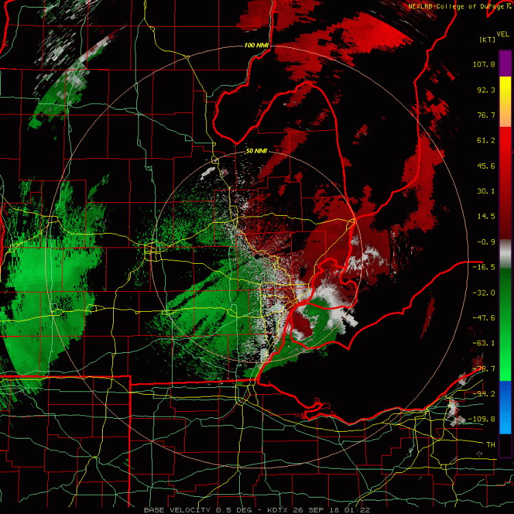
-
2018 Short to Medium Range Severe Thread
Jackstraw replied to tornadohunter's topic in Lakes/Ohio Valley
Was just going to post on that isolated cell ahead of the line in Iowa, TOR warned now. Some of those cells are beginning to get a curved look on radar. -
2018 Short to Medium Range Severe Thread
Jackstraw replied to tornadohunter's topic in Lakes/Ohio Valley
KIND sounding tomorrow evening -
2018 Short to Medium Range Severe Thread
Jackstraw replied to tornadohunter's topic in Lakes/Ohio Valley
SPC has slight Tues. I'm ready to move forward into our mini TOR season in a few weeks. Ultra long term fantasy land showing some signals for some fairly deep lows and a favorable storm track for the sub. Think we're due for some decent late Oct. Nov. fast trackers. -
Major Hurricane Florence: STORM MODE THREAD
Jackstraw replied to stormtracker's topic in Tropical Headquarters
Univ WS Blog on the remnants http://cimss.ssec.wisc.edu/goes/blog/?s=florence -
Major Hurricane Florence: STORM MODE THREAD
Jackstraw replied to stormtracker's topic in Tropical Headquarters
Lot of buoys in shallower water closer to the coast showing a 1-2 degree, upwards to 8 or 9 degree drop in water temp in the last 24 hours. Some up welling and maybe some freshwater runoff. -
Major Hurricane Florence: STORM MODE THREAD
Jackstraw replied to stormtracker's topic in Tropical Headquarters
Looking like signs of an inner and outer wind maxima -
Major Hurricane Florence: STORM MODE THREAD
Jackstraw replied to stormtracker's topic in Tropical Headquarters
I think we could go sub 950 during this recon pass -
Major Hurricane Florence: STORM MODE THREAD
Jackstraw replied to stormtracker's topic in Tropical Headquarters
Nice burst of convection wrapping around the center with overshooting tops. Cloud temps approaching -70 now. Think she just belched. -
Major Hurricane Florence: STORM MODE THREAD
Jackstraw replied to stormtracker's topic in Tropical Headquarters
Starting to see some cool mesos in the eye like we saw with Harvey on Radar. And from the last hour of radar scans it looks like its just about stalled. -
Major Hurricane Florence: STORM MODE THREAD
Jackstraw replied to stormtracker's topic in Tropical Headquarters
Cloud pattern is looking better. Southern outflow is expanding. Also seems to really be slowing down now. Although not deep she's sitting over some high octane rocket fuel.. She got displaced from the upper ridge that was over the top but it may be re-establishing itself from CIMMS wind analysis. -
Major Hurricane Florence: STORM MODE THREAD
Jackstraw replied to stormtracker's topic in Tropical Headquarters
As far as current steering goes it's a quagmire ... -
Pretty crazy stuff from the KILM Disco.... This will likely be the storm of a lifetime for portions of the Carolina coast, and that`s saying a lot given the impacts we`ve seen from Hurricanes Diana, Hugo, Fran, Bonnie, Floyd, and Matthew. I can`t emphasize enough the potential for unbelievable damage from wind, storm surge, and inland flooding with this storm.
-
Consistent signal for some deep ridging over the conus in 10-12 day fantasy land. If that verify's and it can survive the eastern Carib and slip underneath could give it an unhindered path into the south central gulf. If Florence stays N there should be ridging in its wake to help keep Issac on a W/WNW track as it passes the through the Carib. Fun times again this year.
-
Sept-Oct heavy rain and Flooding threat
Jackstraw replied to janetjanet998's topic in Lakes/Ohio Valley
From KIND Discussion... Another point of concern for Saturday afternoon and night is the potential for isolated tornadoes as the surface low moves into the area. At the moment it appears that the southern half of the area would be the most likely area to see this threat given the expected path of the low, but this could change depending on the path. Will mention in the Hazardous Weather Outlook. -
Frost/Freeze ADV/WRN's up for N MN. The utensil drawer is open and forks are in sight for this summer
-
Agreed there, and not trying to Harvey hype lol. Think east central Louisiana/Mississippi up into SE Arkansas could possibly see some 2-3 inch an hour rates isolated in spots as it begins to round the SE periphery of the ridge. It's got a lot of energy built up that is going to have to go somewhere when it begins to lose the tropical fuel.
-
Think there could be some precip surprises with this storm. Even though it's having issues at the surface there's plenty of energy at the midlevels to provide forcing to wring out the moisture. Wouldn't be surprised to see some locally 15 to 20 inch totals if it slows as forecasted.
-
2018 Short to Medium Range Severe Thread
Jackstraw replied to tornadohunter's topic in Lakes/Ohio Valley
Being underneath this ridge has really sucked. Nice light show off to the NW the past few nights to tease. Amazing how far off the storms were. Had a little one this afternoon that broke out for about 15 min directly overhead. May be a sign that the mid level cap is becoming reachable in these parts. Think Gordon remnants will be a little more east than modeled if this pesky inversion over us can be overcome. -
Damn SE Ridge lol


