

Jackstraw
-
Posts
2,592 -
Joined
-
Last visited
Content Type
Profiles
Blogs
Forums
American Weather
Media Demo
Store
Gallery
Everything posted by Jackstraw
-
Just got home last night from Airventure and other activities to the North and this morning Goat and Donkey were staring at me like "why is the grass turning to dirt?" lmao. Turned them into the neighboring "pasture/yard" so they can finish that one off. Everything has missed us this month.
-
Would've been nutz if that would've been 24 hours earlier when the Oshkosh Sunday train was exiting lol
-
93 the highest I've recorded with an index of 102 so thats kinda normal. Usually get some of those a few times a summer. We had solid broken CU field until noon so that helped slow them down a bit today. Overnight lows in the upper 70's to 80 is the killer. Surprisingly, until this afternoon we've had decent afternoon breezes also.
-
It's the overnight temps that bake us. Down south 95/75 or more for months was the norm. But even down there when we had a stretch of night time lows over 80 with dews riding just below the temps it was considered kind of like a heatwave. 25 miles inland and east into central SC is BRUTAL this time of year with Colombia often being the highest temp in the country. I was inland SC when it was 110/87 back in 2012. I mean you couldn't freakin' breathe and I was used to the heat. No breeze at all in those parts lol. This will be good prep for my trip, although I have lived up here long enough that what use to be normal heat for me is pushing it. The big cities in the East are in for it I fear.
-
As always, it ain't the heat, its the Dew's. Sorry, had to lol
-
I lived there for over 20 years, over 10 in Charleston SC so I'm well aware, trust me. This isn't vacation, it's family business. Plus I'll have a pool and literally be across the street from the beach so breezes a plenty as opposed to how stifling it can get here in the still air under a heat dome like the one thats incoming. As to "flying cockroaches" someone mentioned? That's the American cockroach. Its really simple to keep them under control. You just let the native lizards live in and around the house. They are the best indoor (and outdoor) bug control I ever had in my over 30 years in the SE. No worries here. Hell, I'm still so acclimated to the SE that I wear a jacket if its under 70 lol.
-
Loving these temps but I know the rubber band is gonna snap by the 4th so I'm going to FL after the 4th for 2 weeks to justify 95/75 everyday lol.
-
It's been great so far. But me thinks this rubber band is about to snap lol.
-
KIND had a local convective discussion up for a bit on their page. They mentioned dynamic piping tornado initiation. Haven't heard that squirm in a hot minute lol. Makes me wonder if there's an intern there helping them do write ups
-
70/60 Tor Watch just issued for Central Indiana.
-
Just drove home from a Dr visit and despite all the pessimism I'm seeing a carbon copy of yesterday only stronger. The cloud deck was lowering quickly on my way home and the LLJ was just starting to pick up. Dews are slowly rising. I mean yesterday we had evaporative "steam" like you would have after a quick downpour on a 90 degree day as the sun comes back out. No sun and it was 63 degrees. Same thing right now. No sun and "steam" rising off the road and crops and its 66. Temp on my way home across 30 miles moving North went from 71 to 64 when I got home so the WF is coming N, just not as much as many would like. The stratoform clouds with the rain from the earlier wind bag were starting to break and streak, something I've seen many times before as a windbag gets mixed out. Could it still bust? Sure. But there's a train of Hook and Ladder cells from near LAF back to Kansas City racing East. Any of those gets rooted they're gonna spin up, just like yesterday but theres a lot more shear and energy through the column today and tonight. Still ain't callin it, at least through Central IN yet. There's way too much kinetic volatility out there IMHO.
-
Well, this thing is far from over for those of us down in my area and west. There were always 2 shortwaves forecasted with this for the last 72 hours and a lot of questions if the WF would make it up to the IN/MI border after this initial shortwave. Spacing will be everything. The surface reflection is just now getting wound up. TBH, this MCS is coming through a couple hours sooner than I was expecting.. There's still a good chance of recovery as the second SW comes through and the surface low rapidly deepens. I think at least S of I80 to the I70 corridor from MO up through Central IN and Western OH are still going to be under the gun for broken lines of long tracked sups from around 3pm on. Especially if that LLJ cranks up like it did yesterday. You don't need huge Capes and/or dews in the mid to upper 70's with a setup like this. We know this from our experiences with early and late season powerful kinematic setups like this. 60 to 180 veering winds through the column can more than make up for large Capes IMO. I'm not shutting the door at all yet.
-
If it was bit stronger and a bit larger, yeah it could shunt the surface moisture flow into the OH Valley. But I think its too little too late. It's already embedded into the established SW flow of the incoming trough over the conus and will like be absorbed into it. Not a non 0 effect but not as much as if it were stronger IMO. Crazy jet dynamics with the incoming trough, gonna be hard to overcome those.
-
Yep. They're really bullish on keeping the main event long tracked lines of sups with little consolidation. That surface low looks to do a good job of clearing out the brewing line in Iowa after it moves through later. 60+KT LLJ on some of the models is nothing to scoff at. Good long track sup setup its looking like between I70 an I80.
-
I don't know whats gonna happen tomorrow but almost everything thats come through behind that quick line of precip around 2pm has been full on hook and ladder. I don't think I've seen so many wall clouds at once. I mean every updraft was spinning out of the gate. I watched 5 wall clouds and one funnel without moving lol. Crazy stuff.
-
There's shotgun soundings everywhere in IL/IN between I70 and I80 on some of the CAM's. Might be too good lol
-
Mid 980's is getting into Cat 2 Hurricane territory lol. This seems to be a classic Great Lakes/Ohio Valley kinematic setup that we would normally see in some of the Feb/early March or Nov. outbreaks we've had in the past as currently modeled. See how the models respond tomorrow before I get too excited. That upper level jet timing and strength as modeled right now certainly has me intrigued anyway.
-
Thats called a Magic Funnel. It was always there until the smokestack made it "appear". Amaze your friends, only 19.99. But wait there's more.... lmao Pretty cool though
-
Yeah, 49 when the dog took me for an unexpected walk around 6am. I already packed away my sweatshirts. Grabbed a Carhardt out of the closet and ended up sweating lol. Top tier next 7 days except for the frequent rain chances. Rubber band weather.
-
We usually get hit with these setups after sundown as they wane and have turned into basically windbags. Hard to get good sups this far east after April/early May. This may be the last chance before full on ridge riding shrimp season comes in around the 4th. There was a funnel cloud reported that I could've seen from my back porch with the last one (briefly touched down as an EF0 off to my east). Still a lot of if's. I'll have my bicycle ready lol
-
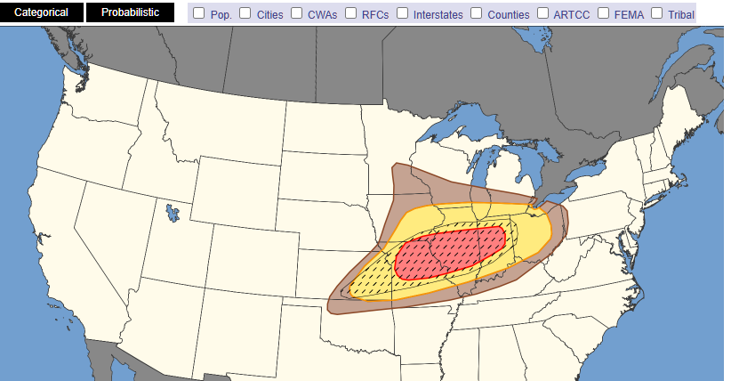
3 day 30% hatched right along the I70 corridor...
-
That's right on top of @IWXwx
-
Stacked bow's from SWMI down through Central IN. Kinks in all of them.
-
I'm warned for some QLCS notches in that fat belly pushing E. Helluva a light show and muggy as shit. Walking outside, chase is on lol
-
There was a CC drop right over Calumet City a few min ago on that tor warned storm


