zippity
-
Posts
178 -
Joined
-
Last visited
About zippity

Recent Profile Visitors
4,135 profile views


-
They are extremely helpful, relevant, and fascinating. Please keep posting them.
- 782 replies
-
- 1
-

-
- extreme cold
- snow
- (and 1 more)
-
Poor Chattanooga...they get missed even more than HSV.
- 782 replies
-
- 1
-
-
- extreme cold
- snow
- (and 1 more)
-
16F with light snow in HSV. Woke up to a dusting. Roads are generally okay but many bridges and overpasses are closed. Schools are closed. My Great Pyrenees is having the best day ever. Good day to bake bread and catch up on some college basketball.
-
Might be burning off fuel for a gear up landing. Hope it lands safely.
- 618 replies
-
- 1
-
-
- observations
- obs thread
- (and 1 more)
-
It's a skating rink down here.
-
25F and the roads are coated in sleet. Dewpoint is 14 F.
- 618 replies
-
- 1
-
-
- observations
- obs thread
- (and 1 more)
-
I was a sophomore at UT in 1982. My sorority had a meeting; the temperature was mildish when we went in, and we walked out to ice covering everything. We were all in skirts and heels, and we basically skated back to the dorms. Seems like there was a lot of snow that winter. I looked it up and the ice storm occurred on January 18, 1982.
-
30 F in Huntsville, 3" snow on,the ground so far. No mixing issues so far. I hope Chattanooga is getting snow; Huntsville and Chattanooga miss out most of the time.
-
Winter Storm Watch issued for north AL: "For 4-6" of snow across the entire region (with higher totals up to 8" possible)." I hope predictions are as optimistic for the rest of the Tennessee Valley.
-
Nuanced discussion from NWS Huntsville: A winter storm is increasingly likely to impact the Tennessee Valley starting Thursday night and persisting through early Saturday morning. A deepening upper level trough will begin to phase with an upper level wave over Mexico on Thursday and eject eastward across the Mississippi and Tennessee Valleys. A surface low pressure system is expected to develop along the Mississippi Gulf Coast late Thursday night then push northeastward through the day on Friday. With temperatures at the onset of precipitation well below freezing, snow begins to overspread from west to east across the local forecast area Thursday night around midnight local. High chances for accumulating snowfall will continue through the day Friday. Given very cold antecedent conditions, snow will almost immediately begin to accumulate on the ground and area roadways resulting in hazardous travel conditions Thursday night through at least Saturday morning. Our current most likely scenario is that 1.5-2.5 inches storm total snowfall will fall across northern Alabama and southern middle Tennessee. However, one major uncertainty is where the transition to a wintry mix, FZRA, or rain occurs. As the LLJ ramps up during the late morning Friday, WAA begins to warm the column bringing a transition from all snow to a wintry mix and possibly FZRA. Our current forecast accounts for this, but if we remain colder and precip falls as only snow then snow totals will certainly increase. Looking at ensemble data, there appears to be more individual members hinting at significantly higher amounts. This will be something to keep and eye on heading towards the start of this winter storm.
-
2024 Atlantic Hurricane Season
zippity replied to Stormchaserchuck1's topic in Tropical Headquarters
I'm so sorry. -
Fall/Winter Banter - Football, Basketball, Snowball?
zippity replied to John1122's topic in Tennessee Valley
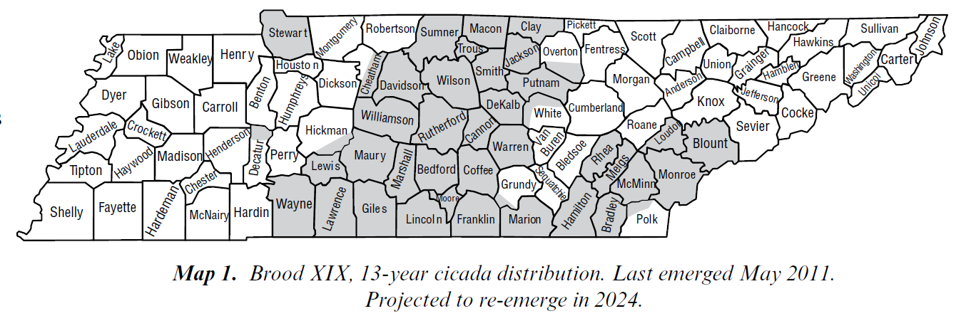
Cicadas! Brood XIX, the Great Southern brood will be emerging this spring, most likely in April/May. Last time they emerged was 2011, not long after the April 27 tornado outbreak. We had so many cicadas in our neighborhood that they covered the houses and the sound was deafening.
-
4C here in Huntsville/Madison. Roads have been treacherous all week since all our precip came down as sleet, but today the roads are kinda sorta passable (those are meteorological terms, right?). Our precip is forecasted to be rain, with the cold arriving quickly enough freeze the wet streets-wéve got a lot of wet, mushy ice that would be fine except that everything is supposed to freeze. I'm very interested to see to the forecasts/models handle the existing snowpack in TN. precip is currently virga.
- 372 replies
-
- 4
-
-
- cold
- arctic blast
- (and 1 more)
-
January 15th-17th 2024 Arctic Blast/Snow Event
zippity replied to John1122's topic in Tennessee Valley
Sorry to hear that. -
January 15th-17th 2024 Arctic Blast/Snow Event
zippity replied to John1122's topic in Tennessee Valley
HSV had reports of frozen precip last night; I am just very slightly west and there is nada-no frozen precip or snow. NWS Huntsville expects an uptick however: By daybreak, expect things to get more active as vorticity advection aids in the persistence of lift along a convergence zone spanning from southeastern Arkansas to the Smokey Mountains. Overall, little has changed regarding amounts. Still expect 2-5" snow accumulations over north and western portions of the forecast area, with lesser amounts and perhaps more in the way of sleet or ice (up to 0.15") south and east of the TN River. Great to see TN is doing so well. How is Chattanooga doing? Has any precip moved in?