weatherwiz
-
Posts
80,212 -
Joined
-
Last visited
Content Type
Profiles
Blogs
Forums
American Weather
Media Demo
Store
Gallery
Everything posted by weatherwiz
-
That road doesn't usually see any sun until like later March or April lol. Went out yesterday and was glad the roads that do get sun were in pretty great shape.
-
That explains it. TBH I've been trying to avoid looking at the temp/dewpoint because it just makes it worse. Not looking forward to this upcoming weekend. I might watch the SB from the inside of a fire place
-

-
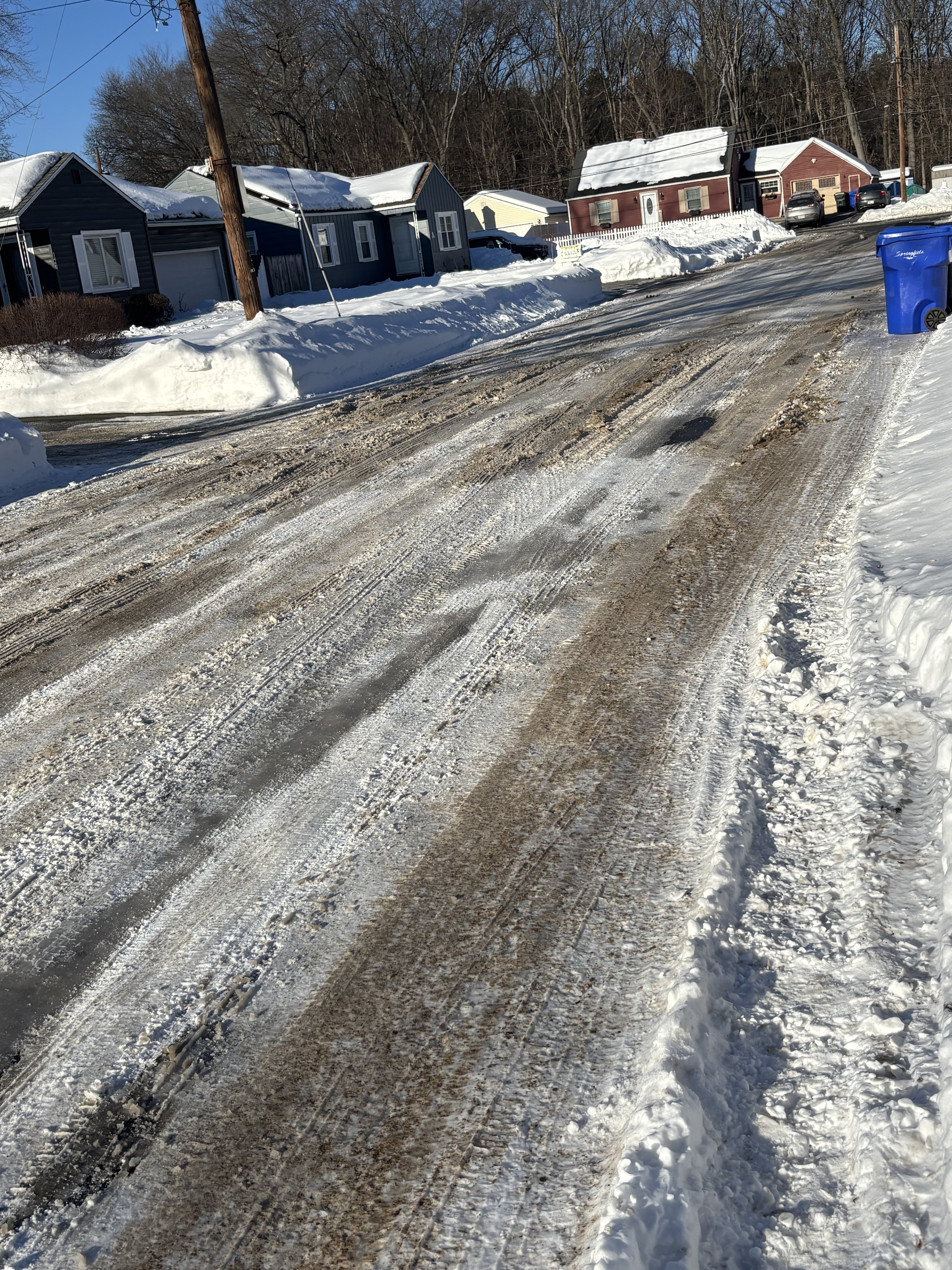
Despite the temperatures and abundance of sun today I am impressed by the lack of snowmelt. The road here is still a complete disaster too
-
Hopefully it breaks down
-
It might only be early February and we may still have several weeks of winter to go, however, that doesn't change the fact winter is getting into its back half which means spring is approaching and pretty soon severe weather season. While its usually not until late May or early June when we start getting some real severe threats May 1 is a great proxy to use because we can sometimes sneak in some early season events and it gives time to switch the mind into convective forecast mode and start sniffing out guidance for potential threats. Just like professional athletes need a pre-season to prepare for the season and shake off the off-season rust, this threat offers the same thing...a good place to talk convection and shake off the rust. With this said, we'll open the countdown at 88 days Its coming and coming quickly
-
It will certainly change. I really wish we could get a good 2-3 year period of ENSO neutral conditions. I think that would go along way of stabilizing things for a bit
-
Well technically it doesn't only affect the northeast coast of the U.S. it has an effect everywhere but the effects (or the results) or just the by product. For us a byproduct is just shitty luck, for areas to our west and south the byproduct is increased potential.
-
Yeah I'll check this out more, Phys.org is pretty great. And thanks for the last paragraph, that is precisely what I was trying to illustrate but could not put into coherent wording. I think having a sound fundamental background in this understanding can go along way in medium range forecasting. If there is one thing I would really love to study further and understand it's wave spacing and factors which influence wave spacing...and then how forecast models handle wave spacing.
-
Can't sum it up any better than this really. When the pattern is not right or the pattern doesn't evolve in a favorable fashion based on historical precedence, it's incredibly difficult to get things to work out.
-
The fast flow idea is something which definitely needs more research...not just in the sense of comparing charts but using the complex mathematical equations to either back up the idea or debunk it and also factor in wavelengths. It's something Ray and I had some dialog on earlier last month and I didn't have much of an answer but I've continued to think about it and have generated some hypotheses on why the fast flow would seemingly hurt us but no where else. An idea which comes to mind is the fast flow greatly alters both the position, strength, and orientation of the ridge/trough evolution downstream of the jet max. When it comes to "fast flow" I don't know if there is any literature which provides some methods or means to defining it, I am going to assume just a simple, "deviating from the mean" so with that the focus on my mind is the strength of the jet max. The second part of this, and this is where I don't have much thought or reasoning is, because of where we are located geographically with respect to "normal" trough/ridge axes and evolution...the faster flow just screws us. Let's look at it in this sense: During the summer, what is one reason why it is extremely difficult (or what seems impossible) to get the extreme heat into our region (I'm talking about widespread >100°F)? The position and orientation of how the southern ridge evolves...it either does so to pump the heat into the West, central states, midwestern states, or mid-Atlantic. Now there are other factors such as airmass modification due to convection, fronts, etc. Back to the cold season, but with the faster flow you are either increasing the likelihood for cyclogenesis and rapid LP strengthening well west of the Appalachians (hence west of us getting hit) or a bit farther off the mid-Atlantic coast or even southeast coast (hence south of us getting hit) but the faster flow disrupts storms potential from coming up the coast. I think this could be similar to that of tornado alley. There has been alot of discussion of whether tornado alley has "shifted" from what it was once perceived. But historically tornado data shows a concentrated area of tornadoes within the Great Plains ("original Tornado Alley") and a secondary concentrated area within the Mississippi Valley area (with a gap between the two). This gap could be explained by shifts within the trough axis based on the flow so either you get periods (years) where tornado activity is concentrated within the Great Plains or where it is concentrated several hundred miles south and east...so the area in between these two has a lower concentration of activity just because of where they happened to reside to the location of the trough axis. This could be a incredibly cool and fun study for someone to heavily divulge into but would requite using primitive equations to explain the flow, changes in the flow, and downstream implications.
-
I don't think the sun isn't doing anything to the snowpack in this atmosphere. Evidence of that is looking at the roofs of peoples houses.
-
 This type of cold hits different when there is snow on the ground. How deep winter should be. But I am soon ready for warmer weather and some stretches of nice spring like weather. That first stretch of 60's we get is going to be something.
 -
Actually I've seen very few myself. Maybe a few. For my birthday my girlfriend got me this little device thing where you like put it over the spider and then slowly move a notch and it traps it so you can put it outside. It actually works kind of well but I told her I can only deal with that up to a certain size. I think there has only been one in the bathroom and I caught one crawling on the floor when I was cleaning. Other than that, nothing else.
-
Possible coastal storm centered on Feb 1 2026.
weatherwiz replied to Typhoon Tip's topic in New England
Guess we'll just call this the storm that could have been. I for sure thought this was going to come up the coast days ago but totally wrong on that. dendrites post this morning illustrated why it wasn't happening and those signals with trough, dPVA, and dynamics were there the whole time to tell the story. -
Possible coastal storm centered on Feb 1 2026.
weatherwiz replied to Typhoon Tip's topic in New England
Starting to even wonder if this ends up being a bit of a bust within the mid-Atlantic. Getting harder to argue against the convection stealing the show -
Possible coastal storm centered on Feb 1 2026.
weatherwiz replied to Typhoon Tip's topic in New England
Lots of disturbing posts today, makes me wonder if some are suffering from too much carbon monoxide intake. Might need to clear snow away from outside vents? -
Possible coastal storm centered on Feb 1 2026.
weatherwiz replied to Typhoon Tip's topic in New England
west, west baby. Come west to me baby -
Possible coastal storm centered on Feb 1 2026.
weatherwiz replied to Typhoon Tip's topic in New England
100% agreed. Overall, it seems very unlikely we see the changes needed but it's much closer than it appears. I also hate comparing storms, particularly different setups and this is nothing like last week. This is a totally different animal and additional processes being added. -
Possible coastal storm centered on Feb 1 2026.
weatherwiz replied to Typhoon Tip's topic in New England
The trough being too far east may be the overarching death killer here. I feel like the GFS is being way too aggressive with that convection, both with scale and intensity. If we remove that, we end up with a much more consolidated system that comes up the coast a bit closer but the trough probably would yield a result just favorable enough for areas towards the Cape -
Possible coastal storm centered on Feb 1 2026.
weatherwiz replied to Typhoon Tip's topic in New England
This reminds me of those times when the GFS goes nuclear with MCS' moving across the midwest and brings them into the Northeast only for reality to be a few circus clouds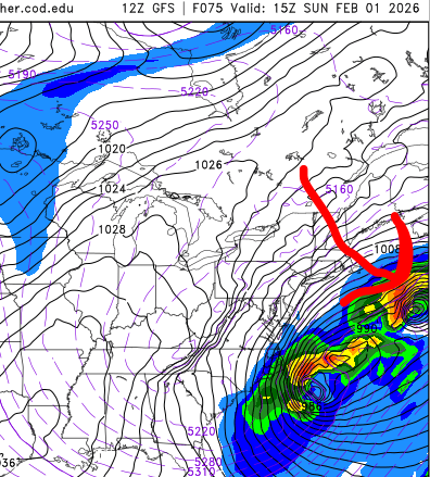
-
Possible coastal storm centered on Feb 1 2026.
weatherwiz replied to Typhoon Tip's topic in New England
If we are ever going to see a substantial model bust in this day in age of models inside of 72 hours, it will be with this setup -
Possible coastal storm centered on Feb 1 2026.
weatherwiz replied to Typhoon Tip's topic in New England
really want to give this until 12z tomorrow before totally writing off...well at least when talking about back towards and west of the CT River. This is going to be a really close call in the end -
Possible coastal storm centered on Feb 1 2026.
weatherwiz replied to Typhoon Tip's topic in New England
don't count your chickens before they shit. We might have something with development right off the coast -
Possible coastal storm centered on Feb 1 2026.
weatherwiz replied to Typhoon Tip's topic in New England
That is a ton of convection chasing on the 12z GFS through 72 oh my