
weatherwiz
-
Posts
81,975 -
Joined
-
Last visited
Content Type
Profiles
Blogs
Forums
American Weather
Media Demo
Store
Gallery
Everything posted by weatherwiz
-

Blowvember - and not named for wind potential
weatherwiz replied to Go Kart Mozart's topic in New England
True, the best way to avoid choking in the playoffs is by missing the playoffs. -
Blowvember - and not named for wind potential
weatherwiz replied to Go Kart Mozart's topic in New England
Well I guess we've arrived to the point in the season where 1. The first "winter" threat is around Thanksgiving. Then when that doesn't happen... 2. EPS shows big pattern change coming around D10...winter should settle in by 12/10. Then when that doesn't happen... 3. Pattern being delayed, but should change around Christmas. Then when that doesn't happen... 4. A bit delayed but EPS still insistent on a change around D10...probably first or second week of January things change. Then when that doesn't happen... 5. Looks like we'll have a window around mid-February, then maybe again early March, otherwise we're cooked. Reminds me of the diagram meme for Cowboys fans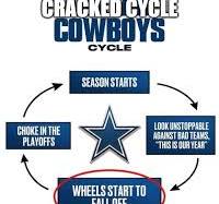
-
Blowvember - and not named for wind potential
weatherwiz replied to Go Kart Mozart's topic in New England
why would you mow the lawn in November lol. And we haven't had rain in like 4 months...why is there a need to mow? -
Blowvember - and not named for wind potential
weatherwiz replied to Go Kart Mozart's topic in New England
Pretty wild. With this wind outside given it’s November 8 you would expect it to be quite cold but it’s actually not terrible out. A bit chilly but could be a lot worse given the wind -
Blowvember - and not named for wind potential
weatherwiz replied to Go Kart Mozart's topic in New England
I mean I would have to think if you get an intense vort to dig and close off just off the coast, given how warm the waters off, combined with that level of mlvl cold...that would be a recipe for a good coastal storm to develop. -
Blowvember - and not named for wind potential
weatherwiz replied to Go Kart Mozart's topic in New England
That is quite the evolution of the pattern during the second half of the week. That is a pretty significant ridge which gets going across the southern states with a quite a bit of shortwave energy rotating around in Canada with some intense systems moving across the Gulf of Alaska into Canada. Don't really care what the differences are at the sfc right now but even the Euro has a somewhat similar evolution to the GFS. -
Blowvember - and not named for wind potential
weatherwiz replied to Go Kart Mozart's topic in New England
Pretty wild language in the warning -
Blowvember - and not named for wind potential
weatherwiz replied to Go Kart Mozart's topic in New England
Pretty wild stuff eastern Colorado and northeast New Mexico. -
Blowvember - and not named for wind potential
weatherwiz replied to Go Kart Mozart's topic in New England
Certainly seems like the northern hemisphere is about to undergo a major shakeup, what that means for an outcome, who knows. But looks like the hemisphere is ready to actually transition to cool season wavelengths with more wave breaking. -
Blowvember - and not named for wind potential
weatherwiz replied to Go Kart Mozart's topic in New England
I mean BDL isn't too far from downtown Hartford. About 15 minutes without traffic....6 hours with traffic. -
Blowvember - and not named for wind potential
weatherwiz replied to Go Kart Mozart's topic in New England
Was outside last night around 10:00 or so, felt so weird to have it so warm in November...with a totally cloudless sky. -
Blowvember - and not named for wind potential
weatherwiz replied to Go Kart Mozart's topic in New England
If we can just somehow shift that ridging over the Aleutians or maintain it and then shift it into the GoA moving into Dec. that could be a big gam changer. But I really worry with how pronounced that ridging is which extends from the Pacific through Mexico and into the Southeast U.S. -
Blowvember - and not named for wind potential
weatherwiz replied to Go Kart Mozart's topic in New England
1000%. What good is a discussion without both sides of an argument? It's how we learn and grow. I mean if we all agreed on the same thing and all had the same analysis and assessment of forecast models...there would be no need for discussion...would be boring as hell haha -
Blowvember - and not named for wind potential
weatherwiz replied to Go Kart Mozart's topic in New England
I'm beginning to think that when it comes our region, outside of strong ENSO events, ENSO has little correlation on us. We've seen weak events and moderate events which have produced poor snow winters, cold winters, warm winter, prolific snow winters, etc. I know there are stats and data out there on this I just don't know it off the top of my head, but let's say like 55% of weak La Nina winters produced above-average snowfall across the major climo sites...that's not really much of a correlation. Given where our region is located, there are so many other influences which help shape and define the pattern that I think at the end of the day the overall correlation of ENSO to us is very little (outside of strong events). I've gone back to the drawing board with assessing La Nina Events, EL Nino events, neutral phases. Starting from scratch with breaking down events by strength (using the oceanic definitions) for the ENS-ONI, ONI, RONI and then looking at SOI data (using Long Paddock method), and then will incorporate MEI data. When it comes to ENSO and defining events, there is so much focus and emphasis on just oceanic SST's but the atmospheric response may be just as critical or hold more weight than the state and structure of SST's. I've also always wondered how much of an influence patterns over Europe/Asia get the ball rolling. How the pattern evolves here eventually has downstream ramifications across the PAC...and this is when you introduce influences such as ENSO/MJO activity which help shape the pattern across the PAC...then this eventually has downstream ramifications on the pattern across North America, however, you also have what's going on within the PNA/EPO/NAO/AO domains which will help shape the pattern across North America. What sucks is we have ENSO data which dates back to the 1800's but obviously that data needs to be used with precaution and we don't have a great database on variables such as OLR, winds, SSTs really until the satellite era began. -
Blowvember - and not named for wind potential
weatherwiz replied to Go Kart Mozart's topic in New England
Fairly heavy frost out there this morning -
Blowvember - and not named for wind potential
weatherwiz replied to Go Kart Mozart's topic in New England
Not when the Bruins have been playing -
Blowvember - and not named for wind potential
weatherwiz replied to Go Kart Mozart's topic in New England
I wish the 70’s to around 80 lasted one more day. I’d watch the Bruins outside today. Everytime there is a chance to watch hockey outside the weather sucks. -
Blowvember - and not named for wind potential
weatherwiz replied to Go Kart Mozart's topic in New England
All bare here too except what I'm guessing are oaks. -
Blowvember - and not named for wind potential
weatherwiz replied to Go Kart Mozart's topic in New England
wasn't being serious edit: it was a joke from several years ago when some trees started to bud in early Feb when we had that massive warm spell. Also think it happened in 2007 before that March cold blast -
Blowvember - and not named for wind potential
weatherwiz replied to Go Kart Mozart's topic in New England
I wonder if the trees start re-budding by the end of the month. -
Blowvember - and not named for wind potential
weatherwiz replied to Go Kart Mozart's topic in New England
Gusts really starting to pick up here -
Blowvember - and not named for wind potential
weatherwiz replied to Go Kart Mozart's topic in New England
That would be pretty damn brutal. The 4:20 PM sunsets are brutal but I could not imagine sunrise that late...I think that would be more depressing than a 4:20 sunset. -
Blowvember - and not named for wind potential
weatherwiz replied to Go Kart Mozart's topic in New England
super dreading the time change tomorrow night. only positive about it is models come out an hour earlier -
Probably the same people who then complain when it's cold.
-
Wanted to sit outside and watch the Bruins but got dinner going to late. Just went outside to get an Amazon delivery and wish I did. This is phenomenal. Who would ever want 30's and 40's or even 50's?





