

weatherwiz
-
Posts
81,158 -
Joined
-
Last visited
Content Type
Profiles
Blogs
Forums
American Weather
Media Demo
Store
Gallery
Everything posted by weatherwiz
-
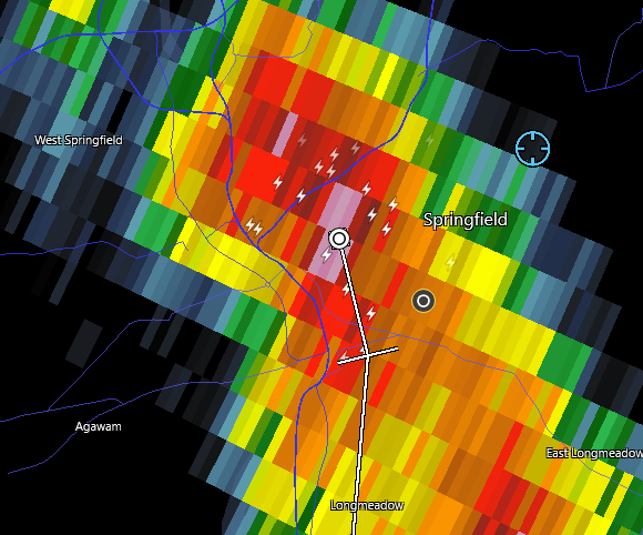
Why can't I ever see anything like that???? Freaking ridiculous. I take a couple weeks during the summer and go around for storms and see shit but people get videos and pictures of funnel clouds, wall clouds, tornadoes, FROM PARKING LOTS OF STORES, FARMS, THEIR HOUSES, SIDE OF HIGHWAYS. Its b**********
-
I'm so pissed. Initial cells around here developed virtually overhead and strengthened as it tracked south (at least I had good thunder). The second round missed me by like 5 miles to the west as the storms dropped south and ended up producing all that hail in Enfield.
-
Could be some good rainfall totals in spots between Sunday and Monday.
-
DUMB
-
Its sliding JUST west
-
decent core headed towards me
-
Shocked there isn't a Special Weather Statement on that cell headed towards Kevin.
-
good thunder with the cell to my south headed into CT
-
yeah I was just outside with the dog and every now and then there is a whiff of a smoky smell.
-
yeah would not be surprised to see some hailers out there today. Wouldn't be surprised to see some transient supercells either towards the east, closer to the sea-breeze boundary.
-
I knew we would see a marginal today
-
Thought we would see a marginal risk at 1730z but I guess we'll have to wait until 6z tonight
-
yup...though I wonder if today is more high terrain.
-
Could see some small hailers and gusty winds tomorrow
-
maybe we can sneak in some EML's during the second half of the month.
-
Don’t they have the strongest/best building codes in the world?
-
eh it seems on track to me with the progression and strengthening. There have been some decent sustained winds and gusts measured thus far. Once the forward speed slows a bit this evening it should get a much more organized structure. This could get to hurricane status just as it is passing northeast of Puerto Rico.
-
It's getting its act together though. Seems on par on terms of development or organization, in fact may even be slightly ahead of forecasts.
-
I get what you're saying, makes sense. I guess with this, what we also need to throw out there is perspective and quantification. There are many different ways I guess we can quantify the season thus far. 1) The number of named storms has been a bit underwhelming comparted to history, especially during a period which was thought to be very favorable for the ATL (low shear, developing Nina). 2) Of the few storms, we had the absolute monster in Beryl - but how much does this skew things so far or is this a sign of what we could be looking at one/if activity ramps up? 3) You're point there in the bolded is something which I think all of us weather enthusiasts like to debate. We talk about this alot in the winter. What makes a winter memorable, is it one massive 2'+ blizzard or is it a bunch of 3-6'' events which add up?
-
Couldn't agree more.
-
I agree. Obviously we could get into September and all hell breaks loose, however, it just boggles my mind how so many people out there (professionals, amateurs) focus on one or two aspects and just go haywire with forecasts. You see it with every type of weather event and within seasonal forecasts. Severe - some will go absolutely wild because of hodographs winter - the 10:1/Kuchie maps...it's too early in the season to get me started on this crap. tropical - warm waters!!!!!!!!!!! winter seasonal - weak la nina...1995-1996 redux. But hype rules all I guess
-
Gonzalo as in this on is gonzo
-
It is definitely screwing with the model, however, in a negative way. Unless something wild were to happen, I can't see that vort being where the center develops or becoming the dominant feature. Those far western outliers should be removed really. Based on the trough progression, combined with where the ATL high is, this thing is going to re-curve sharply. However, there certainly is some room for maybe eastern Atlantic Canada to get some impact. Deviations in storm speed could increase or decrease the chance the trough capturing it and tugging it a bit back northwest.
-
Yup. One of these days those interesting members will be noteworthy but not with this one.
-
maybe we can blame the shitty Red Sox pitching on the solar max


