weatherwiz
-
Posts
79,820 -
Joined
-
Last visited
Content Type
Profiles
Blogs
Forums
American Weather
Media Demo
Store
Gallery
Everything posted by weatherwiz
-
Tomorrow is May, I should have posted that in the May thread
-
Will be interesting temperature wise tomorrow. Essentially, any areas which break into Sun tomorrow will really shoot up. Won't take much
-
Outside of some meteorological setups (CAD for example), the NAM is pure trash when it comes to temperatures...not just here but across the country.
-

May 2024 Discussion - Welcome to Severe Season!!!!
weatherwiz replied to weatherwiz's topic in New England
Get this crap out now and lets full steam summer by mid-May. -
LESS THAN A DAY LEFT IN THE PERIOD!!!!
-
I bet your first 70+ day will be a high in the 80's.
-
yeah the next few days are looking ugly. Hopefully we can those days out of the day now and don't have to deal with this at all moving through May but I don't think we'll get so lucky. We'll have some crap days to deal with.
-
Maybe a few transient supercells across southern NY and northern PA tomorrow afternoon.
-
-
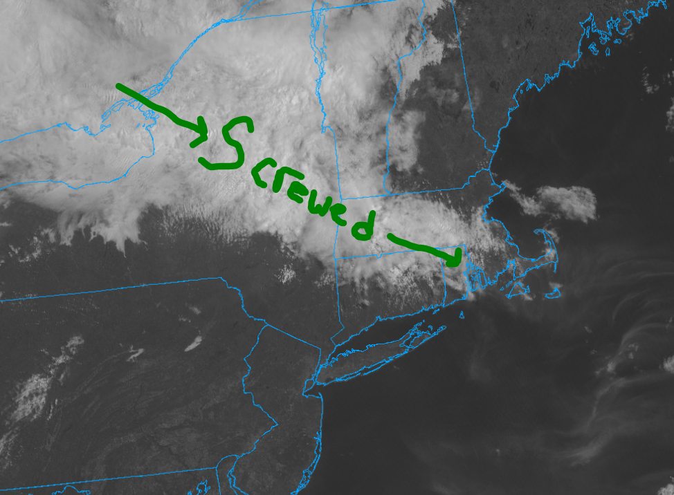
Getting hosed with cloud cover in Springfield
-
Great point. This is going to get OT but I don't care. I was thinking alot about patterns, mostly when it comes to the AI crap. Obviously, understanding weather patterns is a very important part of weather forecasting, whether it be short-term, medium-range, or long-range. However, I think there is a big misconception within the field that there is a strong correlation between weather patterns and what results. For example, major severe weather outbreaks in the Great Plains typically have a deep trough digging into the West with ridging building across the East. However, not every trough digging into the West is going to produce a major severe weather outbreak. During the winter, not every ridge in the West/trough in the East is going to produce above-average snowfall here. But AI focuses on this...all about "identifying patterns" and then saving time because instead of calculating complex equations, a solution is just based on a slew of "historical patterns". BADDDDDDDDDDDDDDDDDDDDDDDDDDDDDDDDDDDDDDDDDDDDDDDDDDDD Understanding the pattern and it's relevance is one thing, however, IMO what's more important is how the pieces are moving and evolving within the pattern which may not be directly related to the pattern at all.
-
It would be nice if we could get a bit of a stretch with ENSO neutral conditions. It's been over decade with a persistent ENSO neutral look (at least based on ONI). I know we don't tend to stay in ENSO neutral for more than a few years at a time but it seems we're either going from one extreme to the next.
-
Very close to the general thunderstorm line the next few days and was in it yesterday. A step in the right direction.
-
One more full day to and and the May discussion thread is up and going. We made it baby!!!
-
May 2024 Discussion - Welcome to Severe Season!!!!
weatherwiz replied to weatherwiz's topic in New England
One type of summer I wouldn't mind would be a repeat of 2008 with the cold pool setups. That was a wild summer. -
Yup busy next few days then Zzzzzz for a bit
-
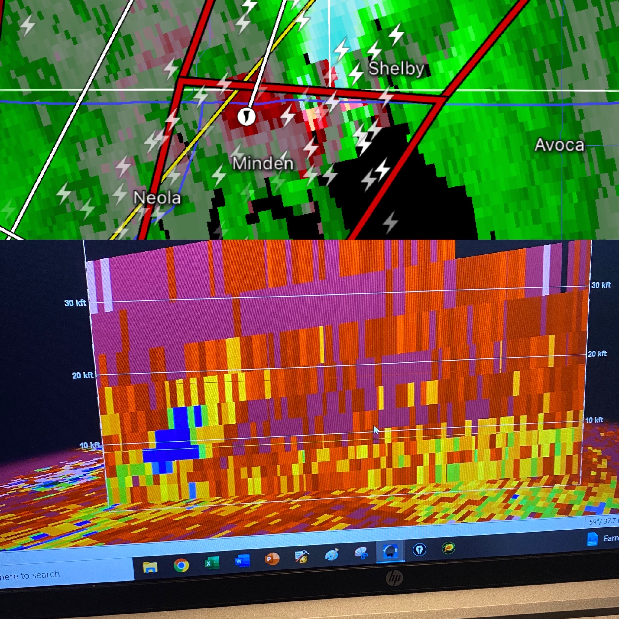
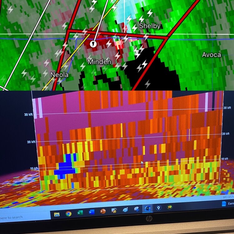
The number of circulations in Iowa is insane
-
Yikes
-
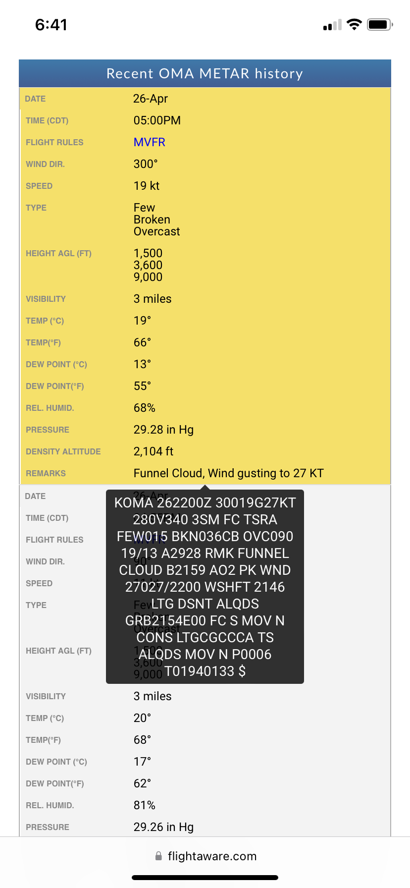
OMA reported a funnel cloud what a situation in Iowa right now

-
Not good for anyone who may have booked early May in the Plains for storm chasing.
-
Yup...sucks how this can often be the case. Maybe we can flip the switch sometime during the second half of May.
-
I don't think it looks that terrible. I mean would we be seeing 80's and some early 90's? No climo is quickly becoming our friend so even if its a little troughy aloft, as long as the sfc isn't crap we will be fine.
-
All those years were good severe weather years here too...hmmmmmm
-
Should at least see some thunder chances next week, great way to kick off first week of May.
-
That might not be too terrible