weatherwiz
-
Posts
79,820 -
Joined
-
Last visited
Content Type
Profiles
Blogs
Forums
American Weather
Media Demo
Store
Gallery
Everything posted by weatherwiz
-
that is a very nasty cell
-
Not poopooing it, just stating that alot of what was being said out there (not referring to the forum) was totally overblown. Some people on fb and Twitter calling for monster tornado outbreak, strong tornadoes, PDS tornadoes. Of all the storms that developed it was only some select cells that were really able to take off. When dealing with NY/PA 3 or 4 tornadoes for an event isn't earth shattering for them.
-
Definitely, my overall concern was how the storms would behave in the environment. I try really hard not to get too caught into the supercell/sig tor parameters, updraft helicity swaths, and the hazard type on those sharppy soundings. My thinking was that largely, storms would really struggle to become mature enough to fully utilize the dynamics present. Outside of the vicinity of the warm front, the forcing was pretty weak, height falls were modest, and you had warming mlvl temperatures. The better forcing and height falls were towards the BUF area and I think that helped with that long-tracked supercell. The weak forcing, lapse rates, and warm mid-levels just told me that as parcels got to a certain level, they would struggle to really rise and produce sufficiently strong updrafts and while the shear was stupendous, there was something lacking (enhanced stretching potential) to develop sufficient rotation throughout the storms.
-
Also most of the action seems to be outside of the highlighted highest risk area. Near BUF and then up along the WF which Scott and Ryan pointed out for good stuff.
-
We'll see what happens once more damage reports come in and surveys but if we come out of this with 3 or 4 tornadoes with like 20+ warnings issued that's a pretty brutal verification rate. Not sure how many warnings there have been so far but it seems like its a big number
-
5/31/98 says hold my beer
-
ehhh. So far 3 confirmed tornadoes. The most impressive cell overall was the one near BUF earlier. Of all the cells and warnings going on, mostly everything has been underwhelming. Just giving good enough looks to warn. Same thing with yesterday, there was the 10% TOR and enhanced risk in southern IL/IN and northern KY...sure there were a few tornadoes but there were more severe weather reports in Maine/New Hampshire than in the enhanced.
-
Today's event reminds me of the Dallas Cowboys offense. Looks good on paper and looks good during the game, however, failing to produce touchdowns.
-
There is one warning that has a 1'' hail tag. Is that just generic wording? You would probably need like 60 dbz to 35000 feet to get 1'' hail today.
-
They're all radar indicated. Though not looking close enough to see if there are any CC drops.
-
So far one confirmed/reported tornado which was 1) well southwest of where the greatest risk area was outlined 2) also much closer to the better forcing from the approaching shortwave. We'll see what happens with the line of supercells between Rochester and just west of ELM but the stuff in central New York has struggled mostly thus far. And stuff along the warm front may be transitioning to torrential rain with embedded tornado potential.
-
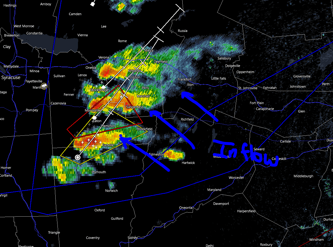
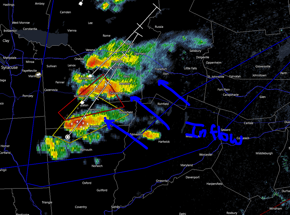
The other thing to consider too is how storms develop and what can remain discrete. If cells are going to develop and "stack" like this, given the inflow direction, the more northern of the stacked cells are going to have their inflow cutoff. southern cells would have the better chance given uninterrupted inflow
-
I'm certainly not saying there won't be a few tornadoes today, just refuting that I don't think we'll see an "outbreak" (several tornadoes). The combination of wind shear and instability is certainly impressive and that is evident by the signatures on the ongoing storms. But we've often times seen similar where the reflectivity's have that "look" but struggle to produce. I've seen some on fb and twitter indicating today as a tornado outbreak with strong tornado potential...that is what I'm disagreeing on.
-
Storms are really starting to go up on radar and there is the confirmed tornado southwest of BUF. But even with these TC related threats, isn't H7 temps >10C still super warm? But I do suppose given the degree of llvl shear and instability it wouldn't take much for things to spin. I wasn't discounting there would be a few tornadoes today but seeing some say stuff like several-plus tornadoes or even strong tornadoes. How does this compare with 8/29/05 (remnants of Katrina coming through). I don't think I've ever gone back and looked at that and that was before I knew about models. I just remember being super excited because on TWC local on the 8's it said, "storms could contain tornadoes" but nothing ever ended up really developing that day (but there is much more going on now than there was that day...I think).
-
All those years too had some big severe weather events either around those dates or during the summer. Some had multiple big events. 2003 was a huge damaging wind event summer, especially NY/PA
-
I hope one of these days we get an Iowa corn-field like environment where we are pooling dews of 79-82 under an EML with a potent approaching shortwave. Everyone start growing corn in you backyards!!!
-
certainly could be a focus. Have to see how everything develops and evolves. Could quickly/easily just become torrential rain and fighting updrafts
-
Idk…I know it’s the product of a tropical airmass but those mid-level temps are extremely warm and warm through the day. I think convection really struggles but we shall see.
-
Maybe one or two tors
-
Pretty soon our "dew downs" are going to be 68-72 versus 74-78.
-
No, yearly blood work and working. There may be one or two good storms but I'm not overly impressed. 700mb temps warm >10C as the day goes on. IMO, this would be too difficult to chase given coverage of any solid storms should be extremely isolated. You would almost have to setup in the perfect spot and get lucky.
-
Now this is summer right here. Cloud-to-cloud lightning across the sky with hot, soupy air. This is what we want
-
Decent light show going on
-
It’s not a bad look. I just saw some folks on fb (who are usually always going aggressive) going wild haha. Certainly anything that can get a good updraft going will have loads of potential. A bit nervous about that capping but maybe closer to that shortwave farther west helps
-
nahh I just love it and embrace it. I don't mind the stickiness and everything that comes with it. It makes me feel alive. nothing better than hopping into a nice warm shower and then feeling all clean and refreshed after.