weatherwiz
-
Posts
79,820 -
Joined
-
Last visited
Content Type
Profiles
Blogs
Forums
American Weather
Media Demo
Store
Gallery
Everything posted by weatherwiz
-
This really sucks but summer is pretty much winding down. Mornings already darker, going to really notice the earlier sunsets over the next month, increased likelihood for cool shots. It sucks how short summer is here.
-
yeah showing some signs as it gets into a bit more of a favorable environment. We shall see what happens. Looks like the GFS actually takes it into the Gulf and blows up there? I'm assuming its the same wave anyways...haven't looked too closely.
-
Are we still chasing a cluster of clouds? must be boring
-
Sucks bulk shear is pretty meh and of course lapse rates blow, however, rich llvl moisture and decent shortwave moving through...should see scattered thunderstorms tomorrow with a few rogue damaging wind gusts. Flash flooding will be greatest concern in poor drainage areas.
-
Don't disagree with that, though I think we're moving too quickly with it. Certainly it can be extremely useful and help with tedious tasks humans have to perform and can help us be more productive.
-
All this money and resources being invested into these "AI models" can be better used elsewhere. This whole AI movement is a big joke. So many companies are trying to fully switch over to AI for customer service (and eliminate call centers to save money). This is going to backfire so badly on these companies...it kind of is actually.
-
Insane rainfall
-
FF Emergency for Saint Johnsbury. That area has become FF magnet
-
It must be because the tropics are dead and people need any reason to try and gear towards the expectations many had this season, but I can't believe all the energy being directed towards a tiny cluster of clouds
-
I see the 6z GFS has picked up in it a bit
-
Not sure what the Euro is picking up on but it seems pretty dead to me through at least the first half of August. At some point things will ramp up just because of climo but lots of shear, dry air, and dust. Not even seeing much in the way of waves coming off Africa and any that do are weak and fizzle.
-
We're definitely going to boost the dewpoints moving into next week and that should be the overall theme for the next few weeks. In terms of getting higher surges of heat in here, that actually may be tough. It looks active with fronts so we may not get the flux of 90's in here. There may be some brief relief at times with the dews (especially the northern part of the region) but its going to be active with shower/thunderstorm potential.
-
was thinking the same thing
-
Presenting is so much fun. Those years of doing lightning talks at past Eastern/Amwx conferences was great experience and confidence builder.
-
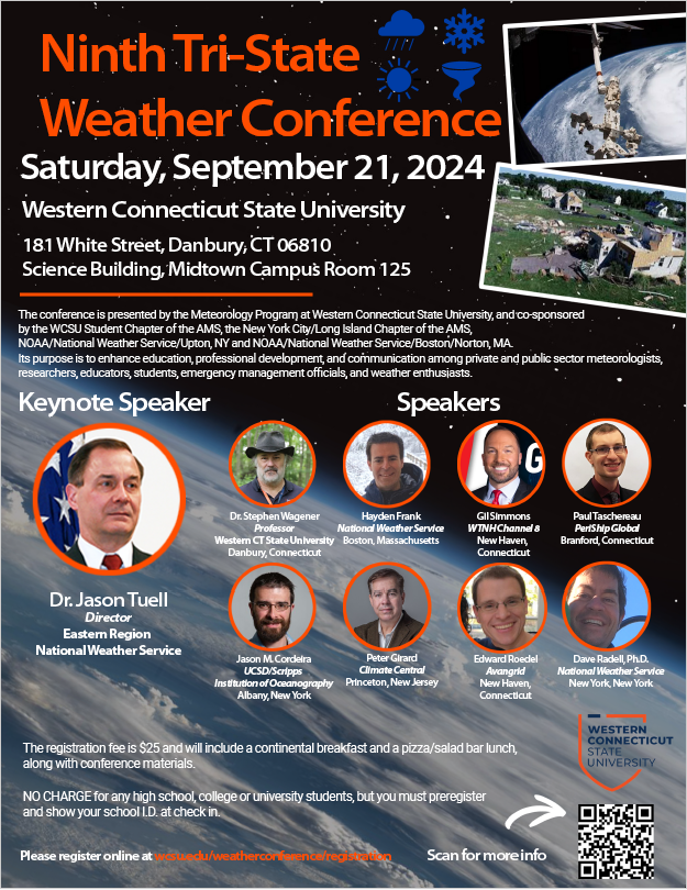
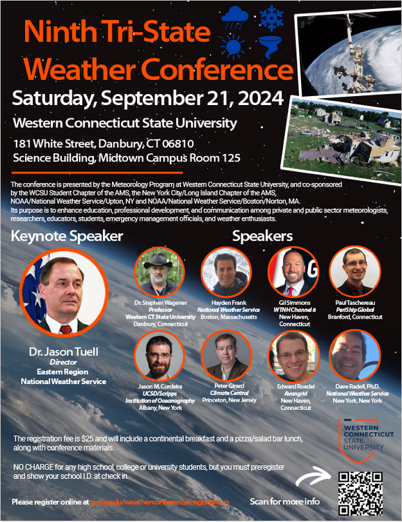
The Western Connecticut State University meteorology program will be holding its 9th annual TriState Weather Conference on Saturday, September 21, 2024 at Western Connecticut State University in Danbury, CT. This has always been a fun conference and at a cheap price. I will also be presenting on the July 1995 derecho as we are approaching the 30th anniversary. If anyone is interested check it out!
- 1 reply
-
- 1
-

-
The Western Connecticut State University meteorology program will be holding its 9th annual TriState Weather Conference on Saturday, September 21, 2024 at Western Connecticut State University in Danbury, CT. This has always been a fun conference and at a cheap price. I will also be presenting on the July 1995 derecho as we are approaching the 30th anniversary. If anyone is interested check it out!

-
ahhh I knew it was one of those years. My memory is fading
-
hmm good question 2013?
-
now we just need a mid-Atlantic derecho
-
Wasn't it the CanSIPS on TT but I swore there was a product for forecast 200mb velocity potential anomalies but I don't see it anywhere on any of the models. Did TT get rid of the product?
-
One product too (at least when it comes to the late spring/summer months here) is the Gulf of Mexico. What I'm about to say is just hypothesis as I don't have any data or maps to show this but I would have to wager that the waters in the Gulf of Mexico have been predominately above-average moving through the Winter months the past few decades. With the Gulf of Mexico running so warm, we're seeing higher dewpoints being brought farther northwards earlier in the season than you would usually suspect. Take this summer, for example. Again, nothing to back this up but there have been some saying the waters in the Gulf were weeks, if not, months ahead of schedule in terms of temperatures. When you're dealing with water temperatures pushing well into the 80's and probably even...lower 90's just think about how much llvl moisture is being fed into the atmosphere. These summer airmasses are becoming so dense and because of the pattern which seems to become established every summer, we're not driving these refreshing fronts south and east of the Rockies until we near the Fall. Even when we get fronts to sort of refresh the airmass here, they are either coming from across the Great Lakes or southeast Canada so the refreshment is brief, as the airmass source to our west and southwest is still juiced. I don't think it gets underplayed but I don't think its taken into account that how much of an influence the Gulf of Mexico has on our climate, despite being so far removed.
-
Yup, I totally get what you're saying. As much as I believe CC is having an influence I'm not going to blame every weather anomaly on CC. For example, dew points well into the 70's are not uncommon in our region during the summer nor are overnight lows only down into the 60's or even lower 70's at times, however, is there an increasing trend for these occurrences...and as we've discussed CC may be playing a role in these frequencies. But yeah...every time I see folks just blaming CC for every weather anomaly or event I cringe. It really pisses me off because the way it is portrayed in the media and argued I think is totally off base...and from both sides and the arguments are totally wrong...but that again is my opinion.
-
Agreed.
-
The next negative cycle I think we're going to learn a great deal on regarding climate. I mean we'll do so anyways just because of improvements with technology, increased data collection, and continued growth with skill but when you look at tropical data and data on temperature records, the coincidence with the flip from -AMO to +AMO is pretty striking. Certainly there is more at play than the +AMO but I don't think the AMO gets discussed or even mentioned, especially within the mainstream media (they probably don't even know what the hell it is). But if you look at all the strides made within the field since the last -AMO cycle, it's remarkable. Maybe one day I'll do a blog post on this. It's all just my opinion but I find it interesting anyways.
-
I am extremely curious to see what happens once the AMO begins to flip towards the negative phase, though I would presume we are still some years away from that. What's the average life-cycle for each phase, like ~30 years? The flip happened around 1995 so you would have to think that we are either at the peak of the +AMO cycle or very close to it. I've always been in the belief that if we're continuing to smash warm records during the next -AMO cycle then we're in some trouble. Now, I don't think we'd see a total regime flip once we go -AMO, it may take some time for the atmosphere to adjust