

weatherwiz
-
Posts
81,330 -
Joined
-
Last visited
Content Type
Profiles
Blogs
Forums
American Weather
Media Demo
Store
Gallery
Everything posted by weatherwiz
-
Def had some weak rotation pass overhead. Rain was coming like a curtain and quickly shifted with a huge gust. Not bad!
-
I think that cell has a BWER though wish I had my laptop to use GR lvl 2 to identify more easily then trying to switch tilts on my phone
-
Might want to look harder
-
Need a warning south of these ones for Charlton
-
Actually I think there was a brief TDS just southwest of Paxton
-
Low CCs but not quite enough for TDS
-
Stuff appears to be getting a bit more oomph. I wonder if the shear lessening is actually helping a bit
-
Interesting around New Braintree
-
Sick!
-
Back end view of the cell to the north
-
Yeah it’s continuing to build. Fingers crossed
-
Beam me up Scotty
-
I can literally feel these updrafts going up around me. Getting dark all around me
-
Hoping that cell over Agawam perks up but not doing much so far.
-
Nice!!!!
-
Bahama blues here. Great looking satellite out ahead of this stuff. Have to wonder though if that mid-level dry air moving in will really hurt, despite the building lower CAPE
-
Have to watch for rapid destabilization out ahead of the line given the sky conditions and rapid jump in temps...may have a similar affect to parcel acceleration that you would see with steeper lapse rates because the air is becoming less buoyant rapidly.
-
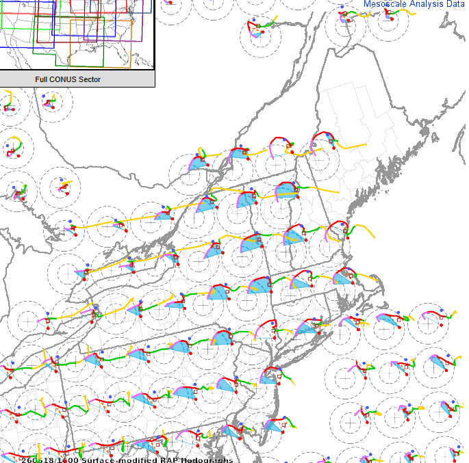
You gotta be careful with TVS in setups like this with very strong shear. I don't think Radarscope does this but these are probably elevated TVS signatures...so there are probably 2 or 3 bins (forget the minimum requirement...think its 3) on successive scans meeting shear threshold and above a certain distance above the ground.
-
Nothing is really standing out in terms of rotation. OF course much of this stuff is in some awful radar coverage but going up a tilt or so, nothing is really impressive so a sign anything llvl is probably minor as well. Don't think there is enough instability right now to really get something spinning. May actually have to watch into Berkshire County...some higher sfc vorticity there per mesoanalysis with increasing 3km Cape.
-
cells firing east or the Berk as the airmass begins to destabilize and MLCIN has eroded.
-
-
Kind of shocked we haven't seen a downstream MCD or watch extension yet
-
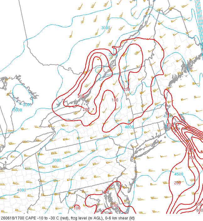
You get enough MLCAPE or 3km CAPE in this and you could be looking at the potential for a stronger tornado
-
The valley probably does but that is going to be the product of mid-level air advecting in which is also going to negatively impact potential for thunderstorm development down this way as well. However, its been noteworthy that the CAMs have become more aggressive and have remained consistent with developing convection, even down into CT later this afternoon. We'll see...too much mid-level dry air can really screw things...not too mention its rather warm aloft too
-
That line is looking pretty good with some very noteworthy rotation. Erode the MLCIN out ahead of it and boost up those values and this may be an interesting afternoon in NNE. Looks good for some clearing out ahead of the line too


