

weatherwiz
-
Posts
81,151 -
Joined
-
Last visited
Content Type
Profiles
Blogs
Forums
American Weather
Media Demo
Store
Gallery
Everything posted by weatherwiz
-

Tracking February 6. Light to moderate event potential
weatherwiz replied to Typhoon Tip's topic in New England
well technically you're right, it is rain. It doesn't fall as freezing rain, the freezing occurs when it comes into contact with a sfc. -
Tracking February 6. Light to moderate event potential
weatherwiz replied to Typhoon Tip's topic in New England
I wonder if that convection down in Kentucky had a negative impact for us. Convection down that way ended up being a bit more pronounced and stronger than anticipated. -
Tracking February 6. Light to moderate event potential
weatherwiz replied to Typhoon Tip's topic in New England
Basically pixie dust out there right now....yuck. It's the Tampa Bay Rays 2008 season outside -
Tracking February 6. Light to moderate event potential
weatherwiz replied to Typhoon Tip's topic in New England
I remember being burned way too many times not buying the warm tongue haha. One big case was the PDII in 2007 (or was that PDI?) -
Tracking February 6. Light to moderate event potential
weatherwiz replied to Typhoon Tip's topic in New England
I've always thought that way too, however, I've changed my stance on that thinking. Obviously everyone has their own preference, but I actually like to start looking at finer details even 3-4-5 days out....not necessarily for creating a forecast, but to just have an understanding or an idea of what would happen if this was unfolding in real time. I think there is great benefit in the forecasting process to look at finer details that far out because you can assess those trends with the trends of the entire storm evolution as its modeled and versus real time. -
Tracking February 6. Light to moderate event potential
weatherwiz replied to Typhoon Tip's topic in New England
The NAM gets tossed way too easily. When it comes to the finer details and mesoscale influences the NAM can do a pretty damn good job. I've come to really like taking the major global models for the synoptics and larger-scale features/evolutions and then applying how the NAM is handling the mesoscale to better define/fine tune expectations. -
Tracking February 6. Light to moderate event potential
weatherwiz replied to Typhoon Tip's topic in New England
Coming down nicely now...some better snow growth over the last half hour or so. -
Tracking February 6. Light to moderate event potential
weatherwiz replied to Typhoon Tip's topic in New England
With where we are now and the ability for people to work from home and even with remote learning, if there is snow, sleet, or freezing rain in the forecast, why make people have to go out and drive. I know not everyone has the luxury to do that (such as essential workers) but if you have people who can work from home or offer remote learning...whatever makes people not need to travel, do it. I know with the remote learning this brings a whole new issue of child care but it's frustrating when you hear about accidents/deaths because of icy roads or weather conditions. -
Tracking February 6. Light to moderate event potential
weatherwiz replied to Typhoon Tip's topic in New England
Growing up in West Hartford, the town was phenomenal with roads...probably was a huge reason why we didn't have a ton of cancellations growing up. It didn't matter the size of the storm, it seemed West Hartford got the roads clear down to bare cement...meanwhile, you went to Hartford...DISASTER. I always got a kick out of right along the town line...West Hartford side, spotless, Hartford side...disaster. -
Tracking February 6. Light to moderate event potential
weatherwiz replied to Typhoon Tip's topic in New England
Yeah good point. It's actually probably moreso the way people drive now that make these situations seem worse. -
Tracking February 6. Light to moderate event potential
weatherwiz replied to Typhoon Tip's topic in New England
ehhh IDK...it seems like local municipalities have really started "slacking off" over the years. And I put slacking off in quotes because I just wonder if its budget related reasons...almost like many towns are preferring for a good chunk of the storms to be over before going heavy with road crews and reducing OT pay. -
It was not a pleasant ride up 91 with some big gusts of wind…had to clutch the steering wheel tightly
-
This wind is nuts. This may be the windiest evening this winter
-
Tracking February 6. Light to moderate event potential
weatherwiz replied to Typhoon Tip's topic in New England
That would royally suck -
Tracking February 6. Light to moderate event potential
weatherwiz replied to Typhoon Tip's topic in New England
This is essentially a 2-3 hour (3 hours probably even stretching for some) humpity, thumpity of snow followed by some light-to-moderate IP (and some ZR in spots) which will make road conditions even worse and clean-up not so fun. -
Tracking February 6. Light to moderate event potential
weatherwiz replied to Typhoon Tip's topic in New England
Agreed -
Tracking February 6. Light to moderate event potential
weatherwiz replied to Typhoon Tip's topic in New England
It's pretty impressive seeing how cold MOS/NBM is for tomorrow night...even down in place like EWR/JFK. -
Tracking February 6. Light to moderate event potential
weatherwiz replied to Typhoon Tip's topic in New England
Thursday morning and afternoon commute will be brutal...roads are going to become a disaster quickly. -
Tracking February 6. Light to moderate event potential
weatherwiz replied to Typhoon Tip's topic in New England
I would probably even go a couple hours prior to Sunrise for start. Maybe even as much as 3 hours. -
Tracking February 6. Light to moderate event potential
weatherwiz replied to Typhoon Tip's topic in New England
This is some impressive WAA...there is certainly going to help with a big thump of snow on the front end.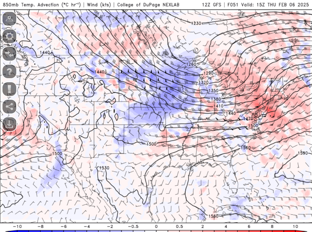
-
Tracking February 6. Light to moderate event potential
weatherwiz replied to Typhoon Tip's topic in New England
I'm starting to think I can pull of 4". If I add the 2.5" from yesterday that would be 6.5"...that would be 10.8% towards my goal of 60" between yesterday's event and mid-March. -
Tracking February 6. Light to moderate event potential
weatherwiz replied to Typhoon Tip's topic in New England
Outside of right along the CT/RI coast and far SE MA...i think everyone stays below 32 for the event and even coastal CT/RI may barely get above 32 -
Tracking February 6. Light to moderate event potential
weatherwiz replied to Typhoon Tip's topic in New England
I was just going to mention that. I don't see anything arguing for a surge of warmer temps at the sfc -
Tracking February 6. Light to moderate event potential
weatherwiz replied to Typhoon Tip's topic in New England
These setups tend to be quicker versus slower for precip. arrival so I am almost inclined to side with the NAM timing wise. -
Tracking February 6. Light to moderate event potential
weatherwiz replied to Typhoon Tip's topic in New England
Might not be totally useless right now though...it may be correct on the timing side of things. The differences in timing amongst some of the models right now is wild.


