weatherwiz
-
Posts
79,817 -
Joined
-
Last visited
Content Type
Profiles
Blogs
Forums
American Weather
Media Demo
Store
Gallery
Everything posted by weatherwiz
-
 That makes sense. Ultimately the banding in this one will surely be farther north and west than projected, unless we really see the system crank as it is lifting northeast and we see it collapse towards the center. But with this I am starting to buy the idea of two banding signals which means there will be trouble in between. I also kind of use alot of hesitation with these point-and-click soundings. I've found you have to pay very close attention because sometimes the soundings generated are erroneous. Doesn't seem to happen alot but something I always note.
 -
I really hope we're setting the stage for a big dog at the end of next week. I am getting extremely excited about that potential. I am going to go on a limb and say we won't see a solution that is OTS. Could be a risk where we get a track that isn't all snow for everyone but I think we are in line for something big end of next week.
-
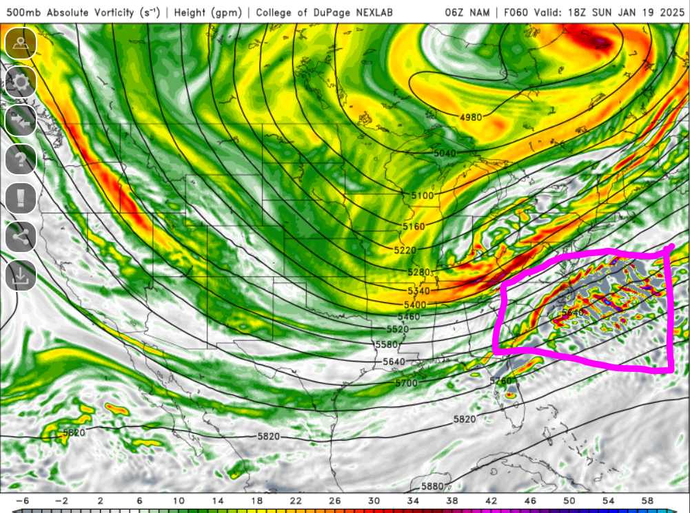
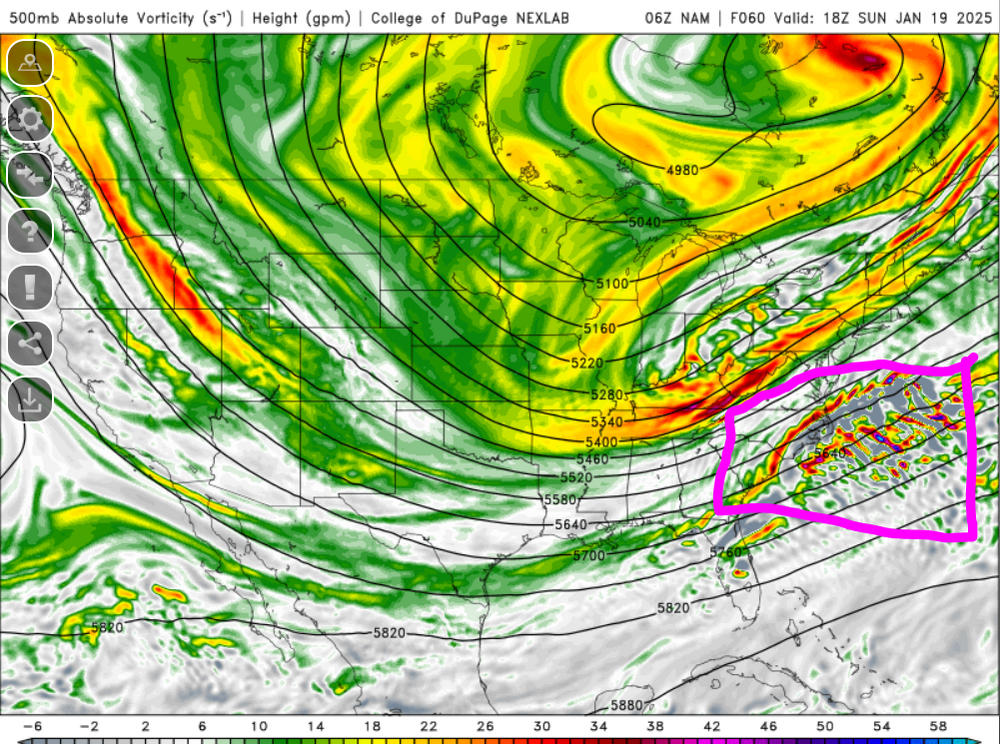
Have to wait on bufkit but looking around on alot of soundings one common theme I'm seeing is alot of the max lift seems to be well below the DGZ. The GFS also may have to distinct areas of banding going on.
-
I include myself in that group
-
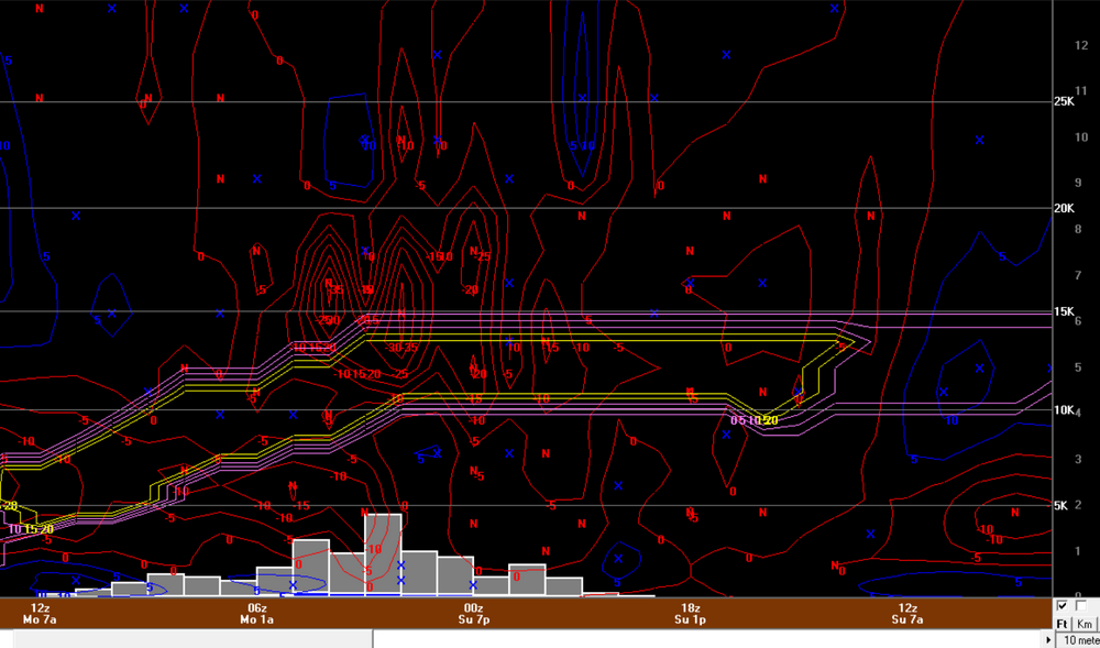
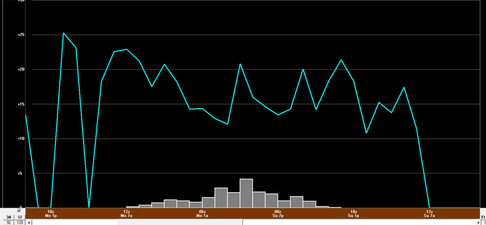
Just an example from northwest Connecticut but that is a quite unstable between 700-500mb. You maximize lift into the DGZ with this look at you're going to get a hefty band. I bet you would see a swath of max totals up around a foot if that verified
-
That's a hefty banding signature on the GFS. Actually almost looks like there could be some dry slot concerns for southeastern CT/RI/far SE MA but those drier H7 RH values are probably coming in as the heaviest QPF is moving out anyways so probably not much of a big deal. But that is also quite an unstable look...pretty good MAUL signal looking at some soundings. Big crushing
-
It looks like it may be slower with the south/eastward progression of the front?
-
Hope we continue the shuffle in the right direction!
-
It is that trend which is leading me to believe the NAM is not going to be correct but like I mentioned, we have seem several events over the past few years where we saw the NAM starting to cave towards other guidance and then all of a sudden other guidance started caving in the other direction. The direction I am leaning in right now is majority receive several inches of snow...that's how I felt yesterday morning when I posted in the main thread that I think this surprises...but I want to keep an open mind right now and understand we have seen some wild shifts inside 48-72 hours in recent years.
-
I'm expecting the NAM not to be correct as well, however, sometimes I think we get a little too aggressive with quickly discounting the NAM. We have all been burned at times in the past discounting the NAM too quickly. Agreed on telling people that a decent snowfall is a distinct possibility but I would be very nervous offering ranges right now. Regarding the 3km vs. 12km...it's wild how much those models can differ and it's something which seems to have gotten worse lately. We've have seen before where we have strong support from global models, even inside 66-78 hours and then once we got inside the 60 hour mark we started seeing big shifts and quickly.
-
I think I saw dendrite talking about this shortwave energy in one of the pages I was catching up on from overnight/this morning but maybe the NAM is being a bit too aggressive with it...too much influence from convection (though convection doesn't look like a big deal). But I guess there are two ways to look a this: 1) The NAM is totally off its rocker 2) It's a feasible reality and something that shouldn't be discounted, especially at this range. We all know the NAM isn't the greatest synoptically, however, it's not like it's presented output here is something that is outlandish or unlikely. It basically just continues indicating there is alot of spread. I'd be nervous putting snow maps out right now, especially if on the aggressive side.
-
yeah for sure...but I guess for the NAM and its putridness with synoptics we take as a win
-
It does seem a bit better aloft so far
-
It can def be a bad thing I can have a terrible tendency of trying to over complicate or get “too cute”. This is exactly why I never get too far with seasonal forecasting, I try to get too peculiar with ENSO breakdowns and I get myself all a mess haha.
-
BDL. I hope this verifies. And I don't mind looking at what ratios look like this far out so don't weenie me
-
I wonder if the NAM is kind of chasing convection a bit there. But whatever...84 hr NAM.
-
I think it also depends on region...some areas it can be brutal in. Obviously it isn't going to handle anomalous patterns well but you're right...you have to know when to deviate from it.
-
Some notable differences aloft on NAM versus GFS/Euro (I know shocker, right).
-
Assuming this stays on course, the NAM should probably start becoming more beneficial 12z or 18z Saturday when really starting to diagnose banding potential and those specifics.
-
I just really hate MOS When I used to participate in the forecast challenge, if you basically ripped and read MOS for temps/wind you would get destroyed. Unfortunately, I still use MOS/NBM a ton because there is no other choice but it is cringeworthy how bad it really is and can be. I know feasibly forecasting specifics like temp/sky cover/wind takes an in-depth dive but if you don't have that capability to really do that...ugly ugly
-
wth...using MOS numbers for snowfall? I didn't realize anyone still did that. MOS is a piece of trash, unfortunately there is nothing else to use for quickly forecasting temperatures.
-
Oh boy...I hope they can incorporate that into bufkit
-
Even better than cobb?
-
Exactly. And with that, I think there is room to see this trend a bit stronger as we get closer and I would lean towards that happening. These trends I think are models catching up to the full potential. The 850/700/500 looks are very good here.