-
Posts
5,269 -
Joined
-
Last visited
Content Type
Profiles
Blogs
Forums
American Weather
Media Demo
Store
Gallery
Everything posted by calculus1
-

Potential 1/28-1/30 2022 winter storm
calculus1 replied to Prismshine Productions's topic in Southeastern States
-

Potential 1/28-1/30 2022 winter storm
calculus1 replied to Prismshine Productions's topic in Southeastern States
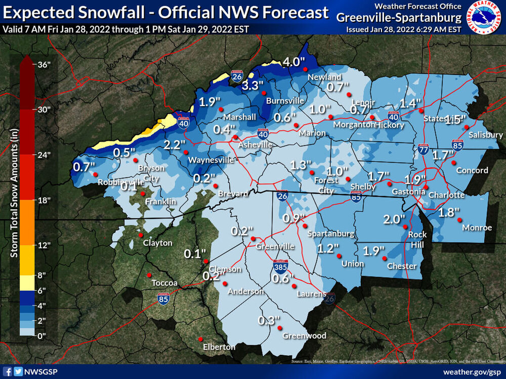
Waking up to Winter Weather Advisories across the NC piedmont. Generally 1-2 inches. Modeled snowfall output has grown rather anemic, though, overall. I would love to get a whole inch of snow tonight. Anything greater than that would seem a nice bonus at this point. -

Potential 1/28-1/30 2022 winter storm
calculus1 replied to Prismshine Productions's topic in Southeastern States
That 2009 storm was absolute torture for those of us living in Caldwell County. That lee side minimum was horrific. -

2021-2022 Fall/Winter Mountains Thread
calculus1 replied to BlueRidgeFolklore's topic in Southeastern States
I hate your map, Hunter. That is all. Catawba County is hung out to dry…. To be clear, I have no issue with its likely veracity. I just don’t like what it portends for Hickory. -

Potential 1/28-1/30 2022 winter storm
calculus1 replied to Prismshine Productions's topic in Southeastern States
Ugh. Such a difference in possible outcomes here in the lee. 12K NAM and RGEM show nothing just to the east of the foothills. ICON, FV3, 3KNAM, and earlier runs of the GFS show a little precip maximum there. So, could get completely blanked here in Hickory or could get a couple of decent inches. Like always, never really know until it’s “Go time”. -

Potential 1/28-1/30 2022 winter storm
calculus1 replied to Prismshine Productions's topic in Southeastern States
I hate these charts even more after reading this article. This article does not explain how ensembles work. It explains how WRAL takes the number of ensemble members that show 1 inch of snow for your backyard out of the total 50 that run with each ECMWF iteration to manufacture a “probability” or “chance” of 1 inch of snow in your backyard. That’s not a “probability” of 1 inch of snow. It’s a “percentage” of ensemble members that show the desired outcome. Those 50 ensemble members aren’t the only possible 50 outcomes for how the storm system could evolve, and they aren’t equally likely outcomes. It’s not a probability. If all it takes to be a meteorologist is being able to calculate percentages of ensemble members that show a particular outcome and making a pretty chart to graph it, then sign me up. Rant over. I’ll shut up now and promise to stop commenting on these charts even though people keep posting them in here. -

2021-2022 Fall/Winter Mountains Thread
calculus1 replied to BlueRidgeFolklore's topic in Southeastern States
Went bowling with the family tonight. Came out to snow falling. Was quite surprised at how much was on the road. Road is completely covered in my neighborhood, with about 1/4 inch of dry snow. Seems we’re at the back edge of the precipitation shield now. Should be ending soon, I guess. -

2021-2022 Fall/Winter Mountains Thread
calculus1 replied to BlueRidgeFolklore's topic in Southeastern States
Still nada in Hickory, despite radar showing otherwise. -

2021-2022 Fall/Winter Mountains Thread
calculus1 replied to BlueRidgeFolklore's topic in Southeastern States
Yeah, but nothing reaching the ground. Yet. -

January 20-22 “bring the mojo” winter storm threat
calculus1 replied to lilj4425's topic in Southeastern States
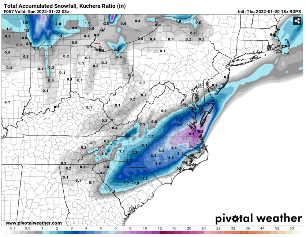
The Canadian is glorious too. A snowstorm for most of the Carolinas. -

January 20-22 “bring the mojo” winter storm threat
calculus1 replied to lilj4425's topic in Southeastern States
-

January 20-22 “bring the mojo” winter storm threat
calculus1 replied to lilj4425's topic in Southeastern States
https://twitter.com/SethMonteith150/status/1483902598734397442?s=20 -

January 20-22 “bring the mojo” winter storm threat
calculus1 replied to lilj4425's topic in Southeastern States
https://twitter.com/webberweather/status/1483813679661563907?s=20 -

January 20-22 “bring the mojo” winter storm threat
calculus1 replied to lilj4425's topic in Southeastern States
-

Weather References and Newbie Information
calculus1 replied to burgertime's topic in Southeastern States
I am not a meteorologist, but I’ve got a pretty good background in mathematics. Having taught the calculus sequence for many years, I can tell you that most students do not find the concepts of calculus that difficult. However, the algebra required to manipulate expressions so that the calculus can be applied is where they get tripped up. My suggestion: really brush up on your algebra skills. Practice, practice, practice with your ability to factor complex polynomial, rational, and transcendental expressions. If you can do that well, you won’t have much difficulty with taking derivatives and integrals. Best wishes with wherever you decide to pursue your degree in meteorology. Don’t be afraid to talk to your professors and seek their help outside of class. Most will actually appreciate that you are interested in learning and are willing to apply yourself. -

January 20-22 “bring the mojo” winter storm threat
calculus1 replied to lilj4425's topic in Southeastern States
Here they go again with their meaningless precision probabilities… 32%…. -

January 20-22 “bring the mojo” winter storm threat
calculus1 replied to lilj4425's topic in Southeastern States
Yeah, really like where the NAM is going at the end of the run. But, I can’t decide if that’s a good or bad thing, because it’s the 84-hour NAM. Virtually no wintry precipitation for anyone with the stalled out front unless you are on the immediate coastline. But, it gets cranking near the end and possibilities abound… -

January 20-22 “bring the mojo” winter storm threat
calculus1 replied to lilj4425's topic in Southeastern States
If it happened a lot, then I might be weary of it. But perhaps we should be leery or even wary of it? Uncertain. -

2021-2022 Fall/Winter Mountains Thread
calculus1 replied to BlueRidgeFolklore's topic in Southeastern States
LOL at @franklin NCwx in the main thread saying we need this thing more amped for a decent storm. Sent from my moto e5 supra using Tapatalk


