

Floydbuster
-
Posts
2,836 -
Joined
-
Last visited
Content Type
Profiles
Blogs
Forums
American Weather
Media Demo
Store
Gallery
Posts posted by Floydbuster
-
-
7 minutes ago, Nibor said:

Channeling Charley 2004...but much larger.
-
 5
5
-
 1
1
-
 1
1
-
-

CDO keeps rebounding rounder
-
-
NHC is thinking this makes a Category 4 Florida landfall.
-
2
-
 2
2
-
1
-
-
Yeah the more I see that pressure and the completion of the ERC, I think it's actually possible we could still see more intensification. Good grief. If those winds really are expanding, then Marco Island and Goodland aren't far from hurricane force.
-
I'm shocked how fast and beautifully Hurricane Ian seems to have completed it's eyewall replacement cycle.
-
1
-
-

The 1919 Hurricane is counted as a 927 mb - 150 mph U.S. Landfall in the Dry Tortugas, so I do believe a landfall would count despite the lack of habitation.
-
 1
1
-
-
Is it possible that Ian makes a first landfall on the Dry Tortugas?
-
3
-
3
-
-
I think once Ian catches up with his satellite signature, it'll be a full blown Category 4.
-
3 minutes ago, GoAPPS said:
I bet the 2 p.m. advisory will raise some eyebrows.
Yeah this looks set to go.
-
1 minute ago, floridapirate said:
Does that signify something?
I read a long time ago that it could be a sign of weakening, but then I've seen multiple hurricanes like Michael and Ida have increased lightning right before they rapidly deepen.
-

What a beaut.
-
2
-
2
-
1
-
-
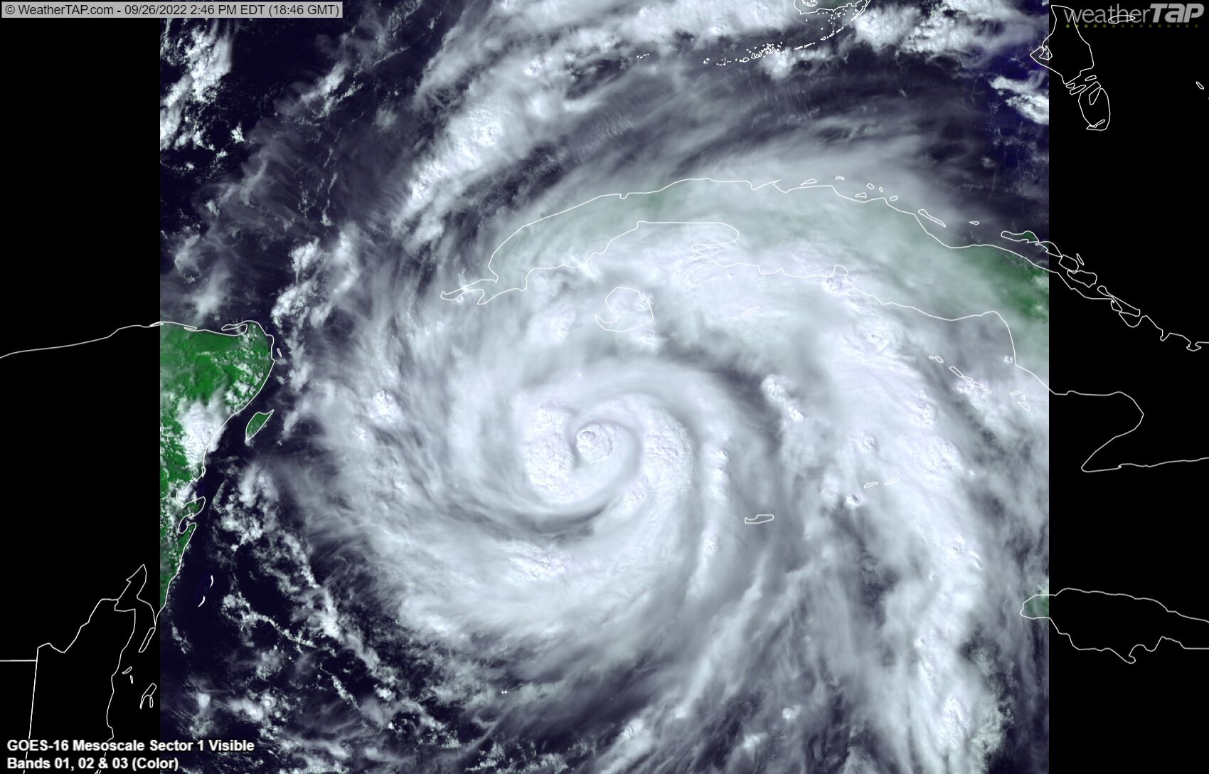
34 minutes ago, CoastalWx said:
Man structure in tact for sure. Cuba did little damage.
Yeah sometimes it hurts (Gustav 2008) but other times it makes no difference (Lili 2002, Charley 2004). It seems that Ian has continued to get better organized. In fact, the symmetry looks better than it did 6-8 hours ago.
-
-
118
WTNT64 KNHC 270631
TCUAT4

Hurricane Ian Tropical Cyclone Update
NWS National Hurricane Center Miami FL       AL092022
230 AM EDT Tue Sep 27 2022

...IAN BECOMES A MAJOR HURRICANE...
...EXPECTED TO MAKE LANDFALL OVER WESTERN CUBA SOON...

Earlier aircraft and more recent satellite data indicate that Ian
has continued to strengthen. The maximum winds are now estimated to
be 115 mph (185 km/h) with higher gusts.

SUMMARY OF 230 AM EDT...0630 UTC...INFORMATION
----------------------------------------------
LOCATION...21.9N 83.6W
ABOUT 35 MI...55 KM S OF THE CITY OF PINAR DEL RIO CUBA
ABOUT 85 MI...135 KM E OF THE WESTERN TIP OF CUBA
MAXIMUM SUSTAINED WINDS...115 MPH...185 KM/H
PRESENT MOVEMENT...NNW OR 345 DEGREES AT 13 MPH...20 KM/H
MINIMUM CENTRAL PRESSURE...956 MB...28.23 INCHES

$$
Forecaster Latto/Brown
-
Is it just my eyes or has Ian slowed way below 13 mph?
-
The Cuban radar looks almost due north at the end.

-
1
-
-
Here's a midnight video update for my fellow night owls. Ian is strengthening faster than the videos can be uploaded! Crazy!
-
4
-
2
-
2
-
-
I wonder if Ian is going to intensify once it moves northeastward with the trough, because right now it looks like it's about to slam into shear.
-
962-964 mb per recon.
-
I'd rather it become a Cat 4 now and weaken rather than take two days and peak right before landfall. That's what happened with Hurricane Michael. He screwed around so much taking his sweet old time being sheared that by the time he intensified, it was too late to weaken before landfall.
-
1
-
1
-
-
35 minutes ago, Superstorm93 said:
The banding structure is incredible with Ian this afternoon.
While the storm has ingested some dry air, I would guess that the bursts near the core have at least dropped the central pressure a few millibars since the last fix.
I would expect the storm to resume a rather quick pace of intensification overnight as it nears the Cuban coast.

Looks extremely similar to Hurricane Lili in 2002 as she crossed over Cuba. Almost 20 years ago to the day.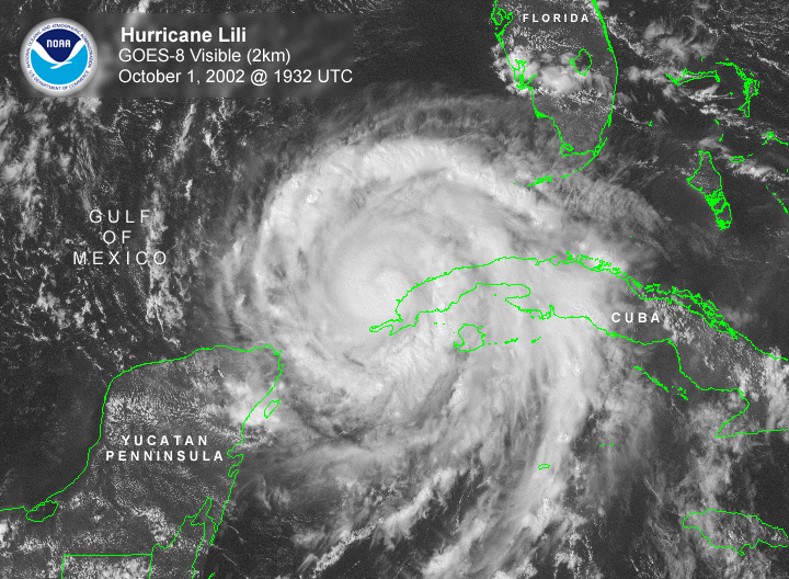
-
9
-
-
-
-
2
-


Hurricane Ian
in Tropical Headquarters
Posted
9am video for anyone interested. I certainly didn't expect this type of storm. One for the ages for SW Florida no doubt.
https://www.youtube.com/watch?v=KdnFILp2Ur0