

Floydbuster
-
Posts
3,069 -
Joined
-
Last visited
Content Type
Profiles
Blogs
Forums
American Weather
Media Demo
Store
Gallery
Posts posted by Floydbuster
-
-
That evening convective burst might just send Francine over the edge into hurricane status.
-
 2
2
-
-
-
-
What is with all of the trolling in this thread?
-
Wow nice shape, Francine!

-
-
GFS continues to show a wave leaving Africa in about 3 days or so, becoming a violent Luis type hurricane strike on the Leeward or Virgin Islands. Starting to gain my interest.
-
 1
1
-
-
-
We already have had one destructive memorable hurricane, for sure. Some years don't produce any. I'm quite confident the name Beryl will be retired.
-
10 minutes ago, salbers said:
By September 10 we get this chance in the ECMWF judging from the model trend loop in the East Atlantic.
We shall see. Still a bit north though. I really think the ITCZ being so far north is a big factor in why August was quiet.
-
3
-
1
-
-
6 minutes ago, CheeselandSkies said:
Correct me if I'm wrong, but I think the 2013 comparison is apt because the alarm bells for this year were hit quite a bit harder than in 2013. 2013 was expected to be active, yes, but not "1933 in the satellite era" levels of insanity from ALL the seasonal forecasting sources of note. So the activity for 2024 has been somewhat greater, yes, but the bar was also set higher.
Again, I could be wrong, since in the July-September period of 2013 I was moving and starting a new job, therefore I probably paid the least amount of attention to tropical weather of my life since I was old enough to watch John Hope on The Weather Channel. It was probably about midway through September when I was like "Huh, shouldn't there be some hurricane threats right about now? Guess it's a quiet season."
Agree on the numbers, but 2013 didn't even produce a U.S. hurricane landfall or a single storm above Category 1 intensity.I never thought this year would exhaust the name list. Those years are exceptionally rare.
-
10 hours ago, yoda said:
There is still time to have more activity, but I am stunned at how silent August was given the odds of such high hyperactivity, especially after a Category 5 hurricane in the Caribbean the first week of July. The 2013 comparisons are not well advised, given that we have already had a Category 5 storm, and two United States hurricane landfalls. Even if nothing else occurred, this season well outpaces that one.
-
2
-
-
On 8/21/2024 at 12:09 AM, Floydbuster said:
Sticking to this. In 7 to 8 days, we will be a tracking a system that will be a major hurricane threat.
Time to commit hurricane seppuku. I was wrong, unless the wave leaving Africa or in the Central Atlantic becomes a significant major hurricane threat.
-
1
-
1
-
-
13 minutes ago, Windspeed said:
Mike, where have you been? Lol... There's been plenty of discussion about the West African Monsoon and latitudinal placement. AEWs do not, or at least rarely, develop north of the CVs when they exit there. That being said, the WAM is losing steam, and it is modeled to do so. ITCZ placement should drop in latitude by September, and the SPH will shift into a more climatogical steering flow for MDR TCs.
I actually think it is somewhat amusing that TC enthusiasts and pro tropical climatologists are all scrambling due to the approaching peak with limited model support. This is mostly due to varying ranges of significantly high named storms numbers. I think forecasting 25+ named storms is a huge risk to take in any year no matter the long-range ECMWF+UKMET superblends, climo patterns, or AMO or ENSO states. Too many caveats and anomolies can occur when all things look extreme. WAM placement and East Atlantic Nino being a perfect example this year. I should stress, however, that WAM will weaken, even if it is abnormally strong. You want some monsoonal enhancement to favor AEWs with a low-latitude ITCZ if you want MDR TCs. We're still going to get that the bulk of September. Sure, NS numbers may not hit all these crazy forecasts, but we will get active, and we will see intense TCs out of the MDR during that stretch.
Back to the present, though the wave south of the CV looks good, modeling support is pretty limited. However, it doesn't look too bad right now, and bears watching. As it moves into the western MDR this coming week, the MJO may time just right to enhance development. Even if limited, some EPS support is there, and that could increase as we get into midweek.I absolutely still expect a very busy season, I'm just curious after the waves in July that led to Beryl, Debby and Ernesto being so low latitude as to why it occurred so suddenly once Ernesto formed. I also think the MJO in mid September may light things alive quite a bit.
-
It is the ITCZ absolutely shunting and blowing waves apart to the north. What the heck is going on?

-
On 7/28/2024 at 6:53 PM, Floydbuster said:
One month from today I am guessing we will have a major hurricane threat for landmasses in the Western Atlantic.
Sticking to this. In 7 to 8 days, we will be a tracking a system that will be a major hurricane threat.
-
1
-
-
5 hours ago, Silver Meteor said:
Charley Part II
My first full year in North Carolina, Wilmington was my new home after leaving Maryland. Then a Cat 1, Charley was a direct hit with the eye passing overhead. The front half eye wall was solid and easily visible from my apartment while the right rear, fully open with lots of blue sky, was oddly enough the strongest part of the storm. I saved a radar image from the time:
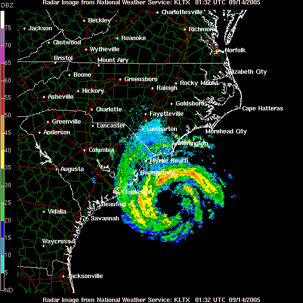
That image is Hurricane Ophelia.
-
1
-
1
-
-
Once again, NE Ohio avoids the doom of the future radar.
This was the future radar for Friday evening....

This was the actual radar Friday evening...

-
-
I discuss this in tonight's video update. I show the analog seasons and how most of the activity is at the tail end of August or later.
-
2
-
-
I cannot believe it has been 20 years since Hurricane Charley struck Florida as a Cat 4 hurricane.
-
3
-
-
That moisture envelope is insane.
-
1
-
-
-
1 hour ago, OHweather said:
Hopefully your power is back on by now! Sorry to hear about the mess on your property but it's good nothing hit your house.
That red elliptical area were winds blowing east with the gust front. The storm was pretty complex...there were east-southeast winds ahead of the squall line (which appeared as inbounds on the radar), a small area of west-northwest winds with the gust front (the red outbounds on velocity), and then a strong surge of northerly winds with a rear inflow jet behind the squall line (which showed up as green inbounds on velocity on the CLE radar). There also was a book-end vortex that came onshore just northeast of downtown Cleveland and tracked roughly east into southern Lake/northern Geauga, which augmented that rear inflow jet. The very strong straight line winds that impacted much of NE Cuyahoga, western Lake, and northwestern Geauga happened as the rear inflow jet wrapped in behind the bookend vortex and the tornado in Chesterland happened in association with that mesovortex.
I think what made this one so impactful was the area hit. Out of the 4 tornadoes, two of them had rather long tracks through very populated areas in the heart of suburban Cleveland. Outside of the tornadoes, there were widespread 60-70 MPH winds from Lorain County into the Cleveland area which caused scattered tree/power-line damage outside the tornado tracks. Into the east side gusts increased to 70-90 MPH, locally up to 100 MPH in northeast Cuyahoga, western Lake, and northwestern Geauga. We actually surveyed that extensive area and only found the one tornado track in Chesterland, along with widespread, significant tree damage caused by straight-line winds. That hit a fairly densely populated area in the eastern suburbs. From there, there was scattered tree damage well to the south and southwest of Cleveland including Medina, Youngstown and the Akron/Canton area which added some impact to the power grid...and the rest of northeast Ohio (Ashtabula, Portage, Trumbull and Mahoning) had scattered downed trees with pockets of more intense damage...the bow echo (and associated bookend vortex and rear inflow jet) continued across southern and eastern Geauga, northern and eastern Portage, southern Ashtabula and northern Trumbull and there were more localized pockets of significant tree damage (not quite to the level of the east side of Cleveland but there were probably pockets of 80 MPH wind all the way across to the PA border embedded within widespread 60+ MPH gusts).
That added up to a relatively localized but significant impact in a very densely populated area surrounded by a large area of less significant damage which added to the power outages. I think last August's derecho and tornadoes (August 24th-25th overnight) would have been more substantial if it hit in the afternoon or evening and not at midnight. The tornadoes with that event were more significant than with this event and the rear inflow jet aloft on radar was larger and stronger. However (and fortunately), the straight-line winds didn't mix down as effectively at midnight when that came through last August...the damage ended up being significant but streaky and relatively scattered with little damage in between. At peak heating, the straight-line gusts with that even would have been much more widespread and perhaps slightly more significant on the top end, so I think the tree damage and power outages would've been more significant that this most recent event. The June 2022 derecho, which crushed portions of north central and east central Ohio, produced a nasty swath of 60-80+ MPH type winds starting in northern IN and northwest OH with pockets of 100-120 MPH in parts of southern Wayne, Holmes, and Tuscarawas Counties. That would have been worse than this if it hit the Cleveland area. Even the November 2017 macroburst (which was associated with a similar bookend vortex and rear inflow jet as this event) across the Cleveland southern suburbs may have rivaled this event's power outage numbers if it occurred more directly over the Cleveland area and happened when leaves were still on the threes.
So my impression is that I'm relatively impressed by this event and it certainly had a high impact, but we've narrowly avoided worse outcomes in the metro area for one reason or another in recent years. So while it is "historic" by a power outage perspective for the Illuminating Company, I do not think it's anywhere near unprecedented for what storms can do in the northern half of Ohio.
What allowed this system to produce higher end severe was a combination of a seasonally strong front and wave of low pressure riding along it, which added lift and enhanced low-level shear, a very moist airmass which allowed for good instability to develop, even slightly north of the front in stronger shear, an incoming shortwave which added large-scale lift and supported quick upscale growth of thunderstorms, and fairly strong winds aloft which provided enough shear for organized/rotating updrafts and mesovortex development within squall lines, which supports stronger bow echoes and QLCS (squall line) tornadoes. It was actually quite a favorable set-up for northern Ohio standards.
Fantastic writeup.
I should note, I don't remember such awful humidity for such a long period of time prior to last weeks outbreak. No doubt that added fuel to the fire.
Hurricane Francine
in Tropical Headquarters
Posted