

Floydbuster
-
Posts
3,060 -
Joined
-
Last visited
Content Type
Profiles
Blogs
Forums
American Weather
Media Demo
Store
Gallery
Posts posted by Floydbuster
-
-
-
https://www.youtube.com/watch?v=jZktngXkxTU
Video Update on Henri
-
 3
3
-
-
-
I'm surprised this thread isn't at 50 pages. Back in the old days of EasternUSWX...people would have been going crazy.
-
5
-
 1
1
-
-
I got the vibe from the 11pm discussion that the NHC ain't buying a New England landfall yet.
-
I think it's possible that Grace becomes a more potent hurricane in the Western Caribbean than we are expecting. It's organizing and slowing down a bit.
-
1 minute ago, WxWatcher007 said:
It’s still incredible to me that we went from a possible S FL hit to possible Bay of Campeche hit in two days.
When in doubt...take the southern route.
-
-
I think it's safe to assume Mexico, now the question becomes how strong does Grace get?
-
1
-
-
Temps in Tampa Bay show almost 87°!
-
-
Atleast he's free of land. That's helping the convection fire big time over the Gulf bathwater.
-
2
-
-
Here's a 12pm Video update. I'm much more interested in 95L this morning than disorganized Fred.
-
Santa Domingo getting lashed pretty hard with gusts and rain via twitter videos.
-
I will say, Southeast Florida has been extremely lucky. Frances could've rolled right into Miami as a Cat 4, instead it sputtered, weakened and sloshed ashore much further north. Had Katrina had an extra 24 hrs over the Bahamas, it would have been a major hurricane over Fort Lauderdale. Matthew just grazed Southeast Florida as a late season Cat 4, and Irma took that south dive into Cuba and the Keys. To say nothing of Dorian, which stopped just offshore West Palm Beach as a 180 mph storm.
-
3
-
-
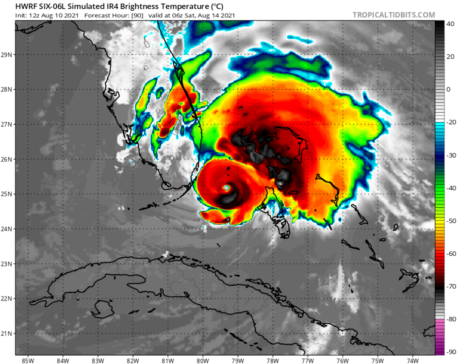
12z HWRF shows a tightly coiled powerful hurricane nearing Miami
-
1
-
-
Looks like some tropical storm force winds and a closed LLC. Not the best defined and I'd like to see lower pressures, but I'd go ahead and give it a name. (and I'm conservative when it comes to naming)
-
Matt, I believe the wave you mention is the same one many of the long-range ensembles show as a potential storm system in the Caribbean or Gulf down the road.
-
1
-
-
That HWRF puts a 973 mb hurricane over Biscayne Bay.
-
11 minutes ago, WxWatcher007 said:
Surprised nobody posted the GFS. It might be a blip, but it really intensifies the system in the Gulf. Looks like a hurricane landfall in the Big Bend area verbatim. Looks like the potential shear vector is further west in the Gulf and that’s enough for this to quickly organize.
Just one run, but interesting..
Yeah. 983 mb.
-
The long-range ensembles show a flurry of activity right on time in late August.
-
1
-
1
-
-
Here's an 11:30pm video update on PTC 6
-
Look at that beautiful anti-cyclone right over the top of it.
-
1
-
-
I definitely think we could see a tropical storm out of this. The longer-range ensembles seem to like the wave leaving Africa this week as a potential Caribbean cruiser and much stronger. We're getting closer to the active times for sure.
-
1
-

Tropical Storm Henri
in New England
Posted
Outflow is fanning out nicely on the northeast side. Looks like the shear has decreased alot.