

Floydbuster
-
Posts
2,838 -
Joined
-
Last visited
Content Type
Profiles
Blogs
Forums
American Weather
Media Demo
Store
Gallery
Posts posted by Floydbuster
-
-
-
 2
2
-
-
9 minutes ago, NorthHillsWx said:
Regarding the doom and gloom posts, a storm moving slowly 100 miles off the coast will not drive catastrophic surge into the coast. Water rise and wave buildup? Sure. Major surge? No. You need the wind energy driving the water inland. I’m not mitigating the threat, but if that Euro run verifies, everyone should breathe a sigh of relief in Tampa.
Other good news, a major system slowing down is usually the worst case for rainfall. In this case, Ian is slowing down while being shredded by shear and dry air. This looks to rip most of the moisture north of the circulation. This is not a prime setup for flooding at least in Florida there will likely be a large dry slot east of the center as the circulation injects dry air from the west.
Lastly, as far as windfield goes, I’m not seeing a massive system. This looks to be modeled as a pretty tight core. HWRF, HMON, EURO, GFS all barely skim the west coast of Florida with TS force winds. As it weakens, those winds do expand from the center but by that time I’m really not thinking a large fetch of 35-50 kt winds would be devastating.
Once again, I am not downplaying this system or it’s potential destruction. However, overnight the modeling trend would shed the core of destructive winds and surge west of the peninsula. We need to temper our doom and gloom for this storm if that scenario plays out, which thankfully would spare millions of people a very destructive hit. Still a lot of variables at play but to see the major modeling push west, the current position being SW of where the models that pushed this near or over the Tampa area yesterday, and continued hostile to extreme hostile conditions modeled across the northern GOM, it looks like we may have an “out” to avoid a destructive impact
This is a good post.
One big factor too is that Florida has some of the best building codes around. You literally had Hurricane Irma's Category 3 eyewall move over downtown Naples, the Naples Airport recorded a wind gust to 142 mph, and then the backside was dry and weak. People literally were taking their dogs to poop like a thunderstorm had moved in a few minutes after the eyewall of this "monster" storm struck. Those building codes are amazing.
To be fair though, Irma's strange angle approach to the coast caused a reverse surge along much of the west coast. Charley's small size limited his surge along the coast. We have yet to see a major hurricane dragging up the western side of the peninsula yet. I'm curious how the surge would be.
-
 1
1
-
-
Wow if that 06z Euro verified, the storm surge would just push straight up Tampa Bay.
-

Hole punch coming soon.
-
1
-
1
-
-
It's a double edged sword. If it slows, the winds could weaken but the wind field expands and the flooding rains and surge are horrendous. If it moves fast, it could bring major hurricane winds into the peninsula.
-
Here's a late night Ian video for the night owls like myself
https://www.youtube.com/watch?v=-Oi2_jjOjRI-
2
-
 1
1
-
-
That CDO should really crank overnight.
-
Anyone have stats on the last direct hurricane impacts to Tampa? I know 1921 was the last direct major strike, but what was the last Cat 1 or 2?
-
1
-
-
-
I'm leaning towards a lower peak intensity but a stronger landfall.
-
4
-
-
As I stated before I went to sleep in the wee hours of the morning, I still favor the EURO solution only because it keeps Ian less organized in the short term, which seems likely because of Ian's current disorganization.
The models further west like the GFS and similar members, all have Ian basically sub 980-mb by late tonight or the wee hours of tomorrow. That just doesn't seem realistic to me given the current state of organization.
-
The EURO shows this becoming a major hurricane, but not right away. 24 hrs from now it's still getting it's act together. That seems much more likely given how disorganized it is right now.
The GFS has this thing taking off immediately and being on it's way to Category 2 status 24 hrs from now. I'm skeptical of that.
Thus, I'm leaning towards the EURO model, atleast short term.
-
3
-
-
I hate to say it, but the EURO looks more accurate as far as Ian's initial organization. It keeps it as a 1000 mb storm over the next 24 hrs, and then strengthens rapidly once in the Gulf. Right now that seems more realistic given it's current state.

-
Watching the satellite, I wouldn't be surprised if we see a reformation somewhere closer to the deep convection more around 15.5N/78.3W.
-
I recall with Charley the NHC had the EXACT final Florida landfall track nailed on an early forecast days before:
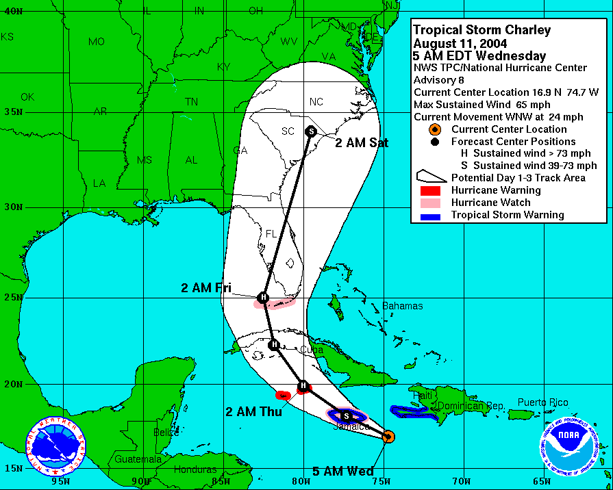
But then the computer models kept insisting it would move further west or ride up the coastline. So they shifted the track west.
The models were also insisting on fast weakening right before landfall:
MAJOR HURRICANE STRENGTH
SEEMS QUITE PROBABLE OVER THE SOUTHEASTERN GULF OF MEXICO ON FRIDAY.
CHARLEY COULD STRENGTHEN A LITTLE MORE BETWEEN THE 12 AND 24 HOURS
TIME PERIODS...AND THEN WEAKEN SLIGHTLY BEFORE MAKING LANDFALL DUE
TO INCREASING VERTICAL SHEAR AND COOLER COASTAL WATERS AROUND THE
TAMPA BAY AREA. THE OFFICIAL FORECAST IS CONSISTENT WITH THE SHIPS
AND GFDL INTENSITY MODELS.
Then of course, Charley moved further east and was much stronger. Just food for thought.
-
3
-
1
-
-
-
Just now, SnowGoose69 said:
Which probably means its wrong given models terrible performance in general with tropical cyclone intensity lol
I remember the models showing Ivan weakening in the Gulf and we waited and waited and waited. It came ashore with 120 mph winds.
-
Some of these models show 40 mb of weakening in six hours prior to landfall. That would be insane.
-
Wow I'm stunned that the NHC is forecasting a drop from a Category 4 all the way to a Category 1 before landfall. Even Frances maintained Category 2.
-
1
-
-
Am I the only one who doesn't think it's that disorganized?
It's not expected to be a hurricane for 36-48 hours. With those waters, low shear and that impressive satellite presentation (even if the circulation is still getting better organized) it can become a hurricane in the blink of an eye.
I think it looks great compared to the tiny blob it was 12 hrs ago.
-
3
-
1
-
-
5 minutes ago, WxWatcher007 said:
Guysborough down to 939.4. That should set the all-time record.
Do you know the lowest record pressure in Nova Scotia?
-
-
I also show in the video the "return period" for a major hurricane in the Ft. Myers/Charlotte Harbor area is 18 years. It's been 18 years since Charley.
-
1
-
-

Hurricane Ian
in Tropical Headquarters
Posted