CT Rain
-
Posts
26,253 -
Joined
-
Last visited
Content Type
Profiles
Blogs
Forums
American Weather
Media Demo
Store
Gallery
Everything posted by CT Rain
-
That shortwave goes through the meat grinder though. Blah.
-

January 16 2021 - Inland runner Rain/Snow/Wind
CT Rain replied to Baroclinic Zone's topic in New England
I saw a slushy inch in Norfolk at 1200ft which is exactly what this met forecast. -
Definitely looks like a few opportunities if we can catch a break. 1/21-1/22 looks pretty good on the EPS.
-
At least we have pretty red colors in the NAO region next week.
-
I'm excited that John will be at a higher elevation that you. He's got an awesome location up there on the mountain!
-
All set, thanks.
-
I'm pretty sure they have a lot of crews staging since they are required by law to do it once they declare the level 4.
-
I'm pretty sure after Isaias they're being as proactive as possible.
-
Yeah - I remember a few events like this with pack and a ripping LLJ. This pack is going to be nuked pretty quickly.
-
3km NAM has some epic upslope precip for the Poconos and Catskills. Have to worry about some flash flooding there especially with snow melt.
-
I was actually just thinking about that storm a few minutes ago. The strongest pressure gradient was pretty localized in that storm so it was really SW CT, Long Island, and NYC metro that got hit hard.
-
I wonder if there's sort of a sweet spot just inland away from the cooler waters where the snow pack gets nuked. Maybe HFD/PVD/TAN?
-
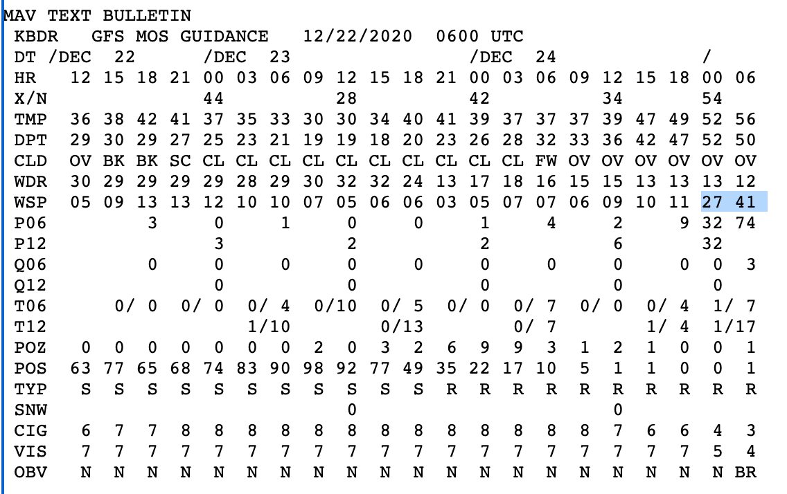
Don't often see >40 knots of MOS around here.
-
Would probably get a name in 2020!
-
There was quite a bit of damage in Guilford from that storm. One of the bigger events I recall growing up.
-
GFS is quite a look that's for sure.
-
I mean who won't want to wake up to text messages from Kevin. "Roaring here. Easily gusting over 60."
- 993 replies
-
- 10
-

-

-
Wild stuff
-
This is a good thread! 1) October 2011 Snowstorm 2) February 2013 Blizzard 3) June 1, 2011 Tornado (was there shortly after in Monson, MA) 4) Tropical Storm Irene 2011 5) Blizzard of '96
-
Vaporized to CYUL? Mid 50s dews and gusting winds will be curtains for the pack south of the Pike.
-
I mean it has 60 knots for MMK and 61 knots to GON. That's not that unimpressive.
-
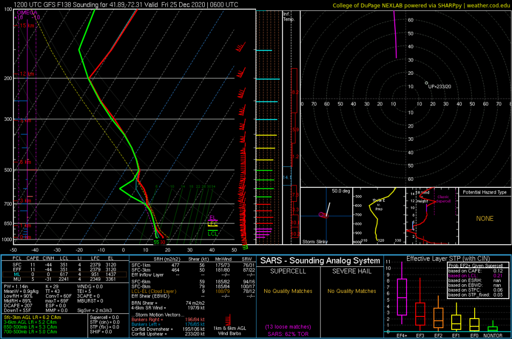
It's the GFS... so all caveats apply... but this sounding for HFD caught my interest.
-
Yeah most snow is a disaster with the 4" gauge so I always keep it inside... unless it's a quick transition to sleet/rain. I can vouch that getting a spouse to keep an eye on a rain gauge... or better yet clear a snow board and do a core.... is not something that will ever happen.
-
If we still have snow pack take the extreme under.
-
Do you leave the gauge out for snow? I always take it in and just do cores with the snow board.