yoda
-
Posts
63,549 -
Joined
Content Type
Profiles
Blogs
Forums
American Weather
Media Demo
Store
Gallery
Everything posted by yoda
-
BULLETIN - EAS ACTIVATION REQUESTED Tornado Warning National Weather Service Baltimore MD/Washington DC 1225 AM EDT Wed Sep 1 2021 The National Weather Service in Sterling Virginia has issued a * Tornado Warning for... Southeastern Madison County in northwestern Virginia... Central Orange County in central Virginia... Southwestern Culpeper County in northern Virginia... * Until 100 AM EDT. * At 1224 AM EDT, a severe thunderstorm capable of producing a tornado was located near Boswells Tavern, or 7 miles southwest of Orange, moving northeast at 40 mph. HAZARD...Tornado. SOURCE...Radar indicated rotation. IMPACT...For those in the direct path of a tornado touchdown, flying debris will be dangerous to those caught without shelter. Damage to roofs, siding, and windows may occur. Mobile homes may be damaged or destroyed. Tree damage is likely. * This dangerous storm will be near... Orange around 1240 AM EDT. Other locations impacted by this tornadic thunderstorm include Nasons, Gordonsville, Madison Mills, Montford, Rapidan, Montpelier Station, Madison Run, Unionville and Locust Dale.
-
Tornado Watch possible for N VA/DC/MD -- https://www.spc.noaa.gov/products/md/md1666.html Mesoscale Discussion 1666 NWS Storm Prediction Center Norman OK 1119 PM CDT Tue Aug 31 2021 Areas affected...northern VA into MD Concerning...Severe potential...Watch possible Valid 010419Z - 010545Z Probability of Watch Issuance...40 percent SUMMARY...A couple of strong cells capable of producing brief tornadoes may spread northeast across parts of northern Virginia and western Maryland. DISCUSSION...A few persistent cells across central VA continue to show periods of low-level rotation as they track along the gradient of stronger 0-3 km MLCAPE. Forecast guidance shows this area of relatively greater instability persisting over parts of northern VA and MD. Low-level shear currently is weak downstream from WW 480 across the MCD area. However, some improvement is forecast as stronger ascent spreads over the region and the stalled surface boundary lifts northward. This could support a few stronger cells with a continued tornado threat into the overnight hours, and a downstream tornado watch is possible. ..Leitman/Edwards.. 09/01/2021 ...Please see www.spc.noaa.gov for graphic product... ATTN...WFO...PHI...AKQ...LWX...
-
LWX AFD from this afternoon SHORT TERM /WEDNESDAY THROUGH THURSDAY NIGHT/... All eyes will turn to the remnants of Ida tomorrow, as a potentially significant weather event unfolds across our area. While there still is a small amount of spread, 12z guidance has started to come into better agreement with respect to the track of Ida and the resultant rainfall distribution across the area. The character of the event can be split up into two separate regimes across our forecast area. The first regime will be to the west of the Blue Ridge, where steady precipitation will persist nearly continuously from tonight through tomorrow afternoon. Dynamically speaking, this is where the remnants of Ida will interact with the mid-latitude trough off to our north and west, undergoing extratropical transition as it tracks across our forecast area. As the remnant wind field and copious amounts of moisture associated with Ida encounter the baroclinic zone associated with the trough to our west, strong warm advection/frontogenesis will ensue aloft, leading to a long lived period of heavy rainfall within the right entrance region of the upper level jet situated to our north. This prolonged period of steady, heavy rain will primarily be located across the WV Panhandle and western MD, where widespread rainfall totals of 3-6" are expected, with localized totals exceeding 8" also possible. Some of these totals may also extend across far northern MD further to the east as the zone of interaction between Ida and the upper jet spreads eastward across PA. This will lead to a high end threat for flash flooding across these areas tomorrow, and then a threat for river flooding in the days following (see hydrology section for details). Locations to the east of the Blue Ridge will be further displaced from the upper trough and resultant jet dynamics. As a result, many locations there may start off the day dry. Not only will locations be dry, but a few breaks of filtered sunshine may develop by later in the morning into the early afternoon hours. This will lead destabilization, with MLCAPE values increasing into the 1000-1500 J/kg range. Also of note from a thermodynamic perspective is the steepening of low-level lapse rates near the surface in many of the CAMs, which when combined with 3CAPE values of 100-150 J/kg should promote low-level stretching of vertical vorticity in any stronger storms. Kinematically speaking, the wind field associated with the remnants of Ida is very impressive, with 40-50 knots of flow extending from 925 hPa all the way up through the mid-levels of the atmosphere. Hodographs have impressive clockwise curvature through up 6 km, making ample streamwise vorticity available to any right moving storms. CAMs show multiple arcs of storms developing to the east of the Blue Ridge tomorrow afternoon. Given the environment in place, any storm that forms tomorrow, whether discrete or embedded within a larger linear structure should be capable of exhibiting supercellular characteristics. Multiple tornadoes and instances of damaging straight line winds appear possible across the area in association with these storms. As a result, the Storm Prediction Center has upgraded a large portion of the area to the east of the Blue Ridge to an Enhanced Risk for severe thunderstorms. While rainfall won`t be steady to the east of the Blue Ridge, individual thunderstorms will be capable of producing very high instantaneous rainfall rates, given the potential for very strong updrafts and the high precipitable water environment in place. As a result, flash flooding is also possible in these areas as well, but on a more localized basis compared to west of the Blue Ridge. Ida`s remnants will progress off to the east overnight Wednesday night, bringing precipitation to an end areawide by daybreak Thursday. High pressure will build in behind Ida during the day Thursday, bringing a return to quieter weather conditions.
-
DAY 1 SPC 1300Z OTLK ...Northern VA to the Delmarva this afternoon/evening... Surface heating will be strongest the first half of the day, prior to the arrival of the thicker high clouds from the remnants of Ida. At the surface, a weak front sagging southward from PA toward northern VA will provide a focus for thunderstorm development this afternoon into this evening. Moderate buoyancy (MLCAPE of 1500-2000 J/kg) is expected in the warm sector as surface temperatures warm into the 80s with dewpoints at or above 70 F. Though midlevel lapse rates will be poor in the moisture plume aloft emanating from Ida, low-level lapse rates will be relatively steep with daytime heating, and there will be an increase in the 700-500 mb flow into the 40-50 kt range this afternoon. These factors will support a threat for damaging winds with the stronger cells/clusters this afternoon into this evening.
-
I think we are at Level 3
-
Thought you would be with LWX going pretty much all in in their morning AFD
-
Looks close to the 06z NAM?
-
I'm hugging the NAM
-
Lord Bezos rules all
-
They do have signs up for the severe weather areas where staff and associates are supposed to go in the building... so the plan is there somewhere. I mean I doubt anything happens... but still is good to plan ahead as you stated
-
Now if you can only get @Eskimo Joe to join in... pretty sure @high risk and @MN Transplant are in
-
Work at DDC3, Amazon DS in Springfield. Most people know I'm a big weather nerd and the such. Just texted our management team about late tonight into Wednesday night re flood threat and tornado threat. This is my favorite part: Me: So there is a good chance of a few tornadoes tomorrow afternoon into early night time period. Let's say there is a tornado warning issued for our area at 9pm (shift starts around then)... does the floor stop what's going on and all staff/AAs report to the severe weather areas in the building until the warning is over? Them: That's a GREAT question. I am not sure how Amazon handles those items from a global operational perspective. Um... okay? Guess I'll be the one making the calls on the floor to manager about any tornado warnings... guess we'll see what happens lol
-
Sorry... we don't have any at our station
-
06z NAM came south with the heavy rain totals... 3 to 7 inches in N VA/DC/MD
-
Sounds fun... have a good and safe trip!
-
-
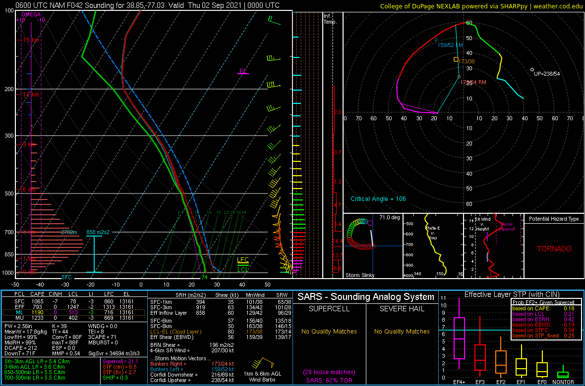
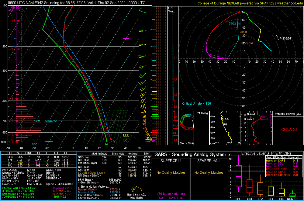
06z NAM NEST sim radar looks pretty ominous at 22z WED
-
LWX gung ho for Wednesday severe .SHORT TERM /WEDNESDAY THROUGH THURSDAY NIGHT/... Wednesday continues to have the potential to be a high impact weather day for our area. In summary, northwestern portions of our forecast area need to prepare for significant rainfall and the threat for flash and river flooding. The southeastern half may see less rain overall, but will have a greater risk of tornadoes, likely during the afternoon and evening. River impacts are discussed in the hydrology section below. Some guidance is indicating the system comes in two pieces. During the morning hours, the heaviest and most widespread rainfall will likely continue to be west of the Blue Ridge in the zone of isentropic ascent/tropical moisture flux. This could serve to allow some additional heating to occur especially over southeastern portions of the area, allowing greater instability to build. The low center will cross our area during the late afternoon and evening, potentially strengthening as it encounters increasing baroclinicity along the stalled front. While models continue to wobble some, and there is definitely some spread in exact solutions, the main stories remain in tact. Precipitable water values will exceed two inches during this time with deep, tropical warm cloud layers. A sharp mid level trough and jet streak to the north will provide additional forcing. Therefore, very high rain rates are possible during this time, which could be especially hazardous to our northwestern counties which will have already had a healthy soaking of rain. Widespread and significant flooding could occur in these areas if the worst case rain totals verify. However, anywhere these rain rates persist for any amount of time could see flash flooding. Meanwhile, low level shear will increase markedly, especially near the low track and frontal zone, but shear will be large across the warm sector. Model forecasts of instability, low level lapse rates, and the shear combine to suggest tornadoes will be a threat in the warm sector. Initial CAM depictions of broken/cellular convection also support this idea. Given the strong winds aloft, storms could also cause damaging wind gusts. At this time, am not sure we are able to mix into the strong wind fields aloft enough to warrant wind advisories, but in general gradient winds will also increase as the low passes. Precipitation will taper off from west to east late Wednesday night into Thursday morning, and clearing should rapidly follow. Timing of departure is still a little uncertain, but most areas should be dry by afternoon. Gusty north winds will continue, and temperatures will remain below normal even where the sun comes out. Lower humidity levels and cold advection will allow for temperatures to dip into the 50s and lower 60s Thursday night, with some potential 40s in the mountains.
-
Still open in morning disco Excessive Rainfall Discussion NWS Weather Prediction Center College Park MD 429 AM EDT Tue Aug 31 2021 Day 2 Valid 12Z Wed Sep 01 2021 - 12Z Thu Sep 02 2021 ...THERE IS A MODERATE RISK OF EXCESSIVE RAINFALL EXTENDING FROM THE PARTS OF THE CENTRAL APPALACHIANS AND MID ATLANTIC REGION INTO SOUTHEAST NEW YORK AND SOUTHERN NEW ENGLAND... ...Central Appalachians/Mid-Atlantic northeast into southeast New York and southern New England... Very heavy rainfall will continue to spread northeastward on Wednesday across portions of the central Appalachians, central/northern Mid-Atlantic region, and up across southeast NY and southern New England as the extratropical low center of Ida makes its way across northern VA, central/eastern MD and southern NJ before then heading offshore to the south of Long Island. Moisture and instability will continue to surge northward around its eastern flank and over a rather strong frontal zone draped across the region. Enhanced moisture convergence, strong frontogenetical and isentropic ascent just north of the front, and focused right-entrance region upper jet dynamics over the region will foster locally several inches of rain, including the potential for some areas to see 4 to 6+ inches totals from the WV/MD Panhandles east/northeast across south-central PA. A fairly broad Moderate Risk area is again highlighted to account for the latest forecast guidance and storm track of Ida. While a High Risk area may ultimately be needed, but too much uncertainty lingers to Ida's exact path at this point to warrant an upgrade now.
-
SLGT risk for today as well for VA into MD and DC
-
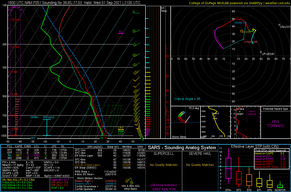
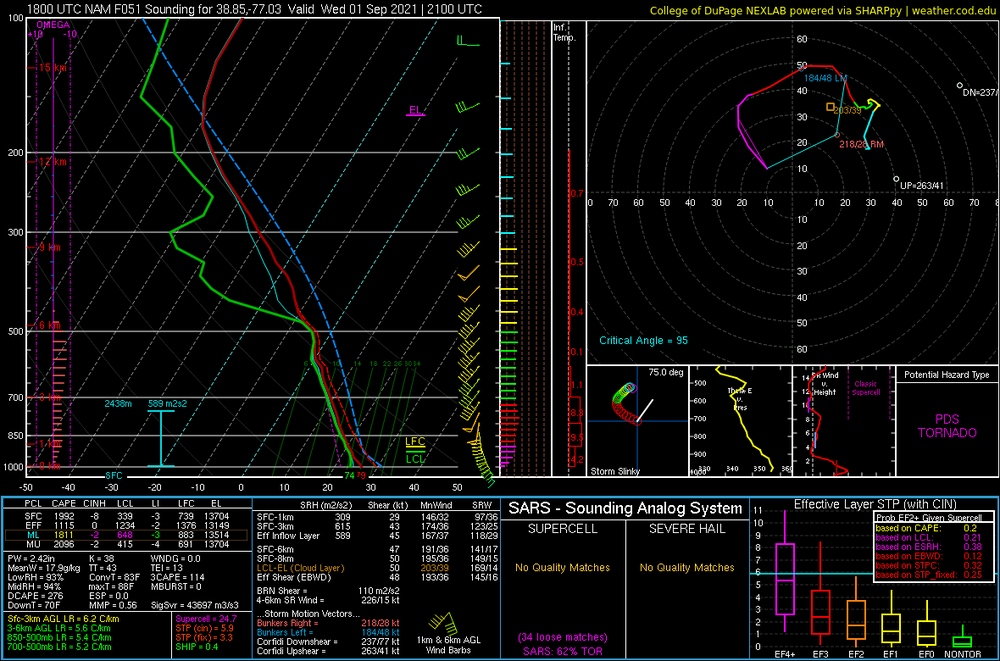
Lulz... DCA sounding for 21z WED
-
18z NAM sim reflectivity shows a pretty strong line of storms pushing through as an Ida finale at 00z Thursday
-
Pretty impressive soundings at KIAD and KDCA based off the image lol... 45 to 50 kts 0-6km shear and nice hodo along with impressive low level shear Same at KEZF and KBWI
-
Does slightly look like Isabel tbh at first glance lol
-
 Tropical Storm Kate Discussion Number 11 NWS National Hurricane Center Miami FL AL102021 500 PM AST Mon Aug 30 2021 The low-level center of Kate is exposed in visible satellite imagery this afternoon. Its deep convection collapsed late this morning, and the sheared tropical cyclone is now only producing a small area of convection over 60 n mi east of its center. A partial 1321 UTC ASCAT-B pass still showed numerous 30-kt wind vectors in the eastern semicircle, even with little to no active convection. The initial intensity is conservatively lowered to 35 kt for this advisory. The subtropical jet stream across the central Atlantic will continue to impart strong west-northwesterly vertical wind shear on Kate during the next day or so. If the struggling tropical cyclone can survive these hostile conditions, some modest strengthening could occur later this week over warm SSTs of 28 deg C or so. However, the lack of mid-level moisture in the surrounding environment may limit convective development even under these more favorable conditions, and there is no guarantee that Kate will survive that long. In fact, simulated satellite imagery from the GFS and ECMWF suggest that Kate may continue to only produce sporadic bursts of convection over the next couple of days, which jeopardizes its chances of surviving through the week. The official NHC intensity forecast has been adjusted downward based on the latest guidance trends and the uncertainties discussed above. Minor fluctuations in intensity could occur over the next 24-36 h as convective pulsing causes the cyclone's intensity to hover around tropical-storm-force strength. Kate is moving a little faster toward the north, or 355/9 kt, within a weakness in the subtropical ridge. A northward motion is expected to continue through early Tuesday. The subtropical ridge is expected to become reestablished over the central Atlantic Tuesday night into Wednesday, which should turn Kate toward the northwest through midweek. Thereafter, Kate is forecast to accelerate northward or north-northeastward ahead of an approaching deep-layer trough that will move across the western Atlantic late this week. Assuming Kate is still around by day 5, the cyclone is forecast to become absorbed by a larger extratropical low near Atlantic Canada. FORECAST POSITIONS AND MAX WINDS INIT 30/2100Z 22.7N 50.9W 35 KT 40 MPH 12H 31/0600Z 23.7N 50.7W 30 KT 35 MPH 24H 31/1800Z 24.7N 50.7W 30 KT 35 MPH 36H 01/0600Z 25.8N 51.1W 35 KT 40 MPH 48H 01/1800Z 27.0N 52.1W 35 KT 40 MPH 60H 02/0600Z 28.4N 53.5W 40 KT 45 MPH 72H 02/1800Z 30.1N 54.7W 40 KT 45 MPH 96H 03/1800Z 34.5N 55.0W 40 KT 45 MPH 120H 04/1800Z...DISSIPATED $$ Forecaster Reinhart