yoda
-
Posts
63,549 -
Joined
Content Type
Profiles
Blogs
Forums
American Weather
Media Demo
Store
Gallery
Everything posted by yoda
-
I know it was only one pass... but 943mb to 966mb in 12 hours... wow Dry air really did a number on Sam until recently
-
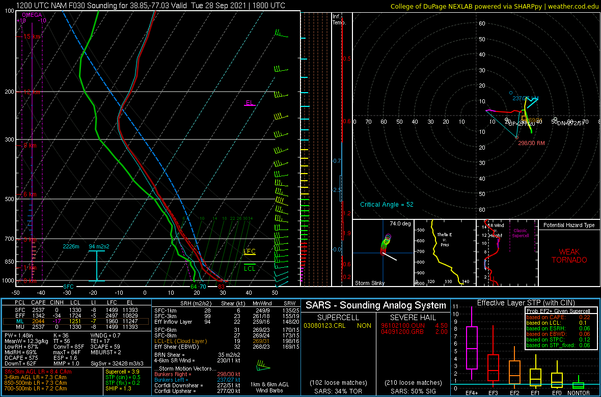
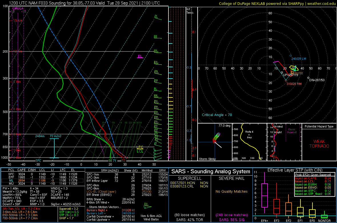
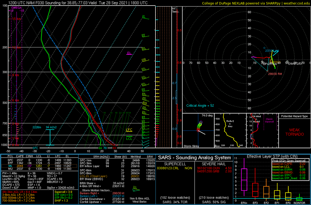
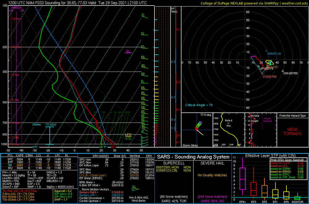
12z NAM at KDCA for both 18z and 21z TUES shows quite a large amount of SARS loose matches for severe hail... and even supercells
-
Looking at the 12z NAM soundings... I'd think 2500 SBCAPE with LI in the -7 to -9 range is a bit overdone... but hmmm ConvT is in the low 80s... should breach that in the afternoon
-
AFD was discussing 1000 CAPE with potential of over 2000
-
MRGL for Tuesday... 0/5/5
-
Hurricane Sam Discussion Number 19 NWS National Hurricane Center Miami FL AL182021 500 AM AST Mon Sep 27 2021 The satellite presentation of Sam deteriorated overnight, as GOES-16 infrared imagery showed periodic disruptions to Sam's inner core convection. The eye has not been readily apparent in conventional satellite imagery for much of the night, although very recent imagery suggests an eye could be re-emerging. Data from the reconnaissance aircraft last night indicated that an eyewall replacement cycle (ERC) was underway, and some dry mid-level air impinging on the western side of the circulation could also be negatively impacting Sam. No recent high-resolution microwave data is available, but an earlier scatterometer pass revealed that the tropical-storm-force wind radii had expanded just a bit in the eastern semicircle of the hurricane. The initial intensity is lowered to 115 kt for this advisory based on a blend of the objective and subjective Dvorak current intensity estimates. A NOAA hurricane hunter aircraft is scheduled to investigate Sam later this morning, which will provide crucial data to assess changes in Sam's structure and intensity. The initial motion is estimated to be northwestward, or 315/7 kt. A subtropical ridge to the north and northeast of Sam will remain the primary steering mechanism over the next several days, and Sam is expected to maintain a northwestward heading through midweek. Then, a mid- to upper-level trough is forecast to dig southward over the western Atlantic late this week. The deep-layer southerly flow ahead of this feature should cause Sam to move faster toward the north-northwest by 96 h, followed by a northward acceleration thereafter. The NHC forecast track is shifted slightly to the right of the previous one through the first 48-60 h of the forecast period, which accounts for the more northwestward initial motion observed during the past 12 h. Otherwise, the NHC track is virtually unchanged as the guidance has remained fairly consistent. Sam's intensity has likely peaked now that an ERC has commenced, but environmental conditions should allow Sam to persist as a major hurricane for the next several days. Sea-surface temperatures are expected to be 28 deg C or greater along Sam's track through 120 h, and the vertical wind shear is forecast to remain weak (< 10 kt) through at least midweek. Thus, the official NHC intensity forecast only shows very gradual weakening during the next several days, generally following the HCCA and IVCN consensus aids. Given the lower initial intensity of Sam, the latest NHC forecast is once again lower than the previous one. By 120 h, southerly shear associated with the deep-layer trough is forecast to increase over Sam, which should induce more weakening by this weekend. FORECAST POSITIONS AND MAX WINDS INIT 27/0900Z 15.2N 51.4W 115 KT 130 MPH 12H 27/1800Z 15.9N 52.2W 115 KT 130 MPH 24H 28/0600Z 16.8N 53.3W 115 KT 130 MPH 36H 28/1800Z 17.7N 54.4W 115 KT 130 MPH 48H 29/0600Z 18.6N 55.6W 110 KT 125 MPH 60H 29/1800Z 19.6N 57.1W 110 KT 125 MPH 72H 30/0600Z 21.0N 58.8W 110 KT 125 MPH 96H 01/0600Z 24.9N 61.6W 110 KT 125 MPH 120H 02/0600Z 30.5N 62.0W 105 KT 120 MPH $$ Forecaster Reinhart
-
Hurricane Sam Advisory Number 19 NWS National Hurricane Center Miami FL AL182021 500 AM AST Mon Sep 27 2021 ...SAM EXPECTED TO REMAIN A MAJOR HURRICANE FOR SEVERAL DAYS... ...HURRICANE HUNTER AIRCRAFT TO INVESTIGATE SAM LATER TODAY... SUMMARY OF 500 AM AST...0900 UTC...INFORMATION ---------------------------------------------- LOCATION...15.2N 51.4W ABOUT 800 MI...1290 KM ESE OF THE NORTHERN LEEWARD ISLANDS MAXIMUM SUSTAINED WINDS...130 MPH...215 KM/H PRESENT MOVEMENT...NW OR 315 DEGREES AT 8 MPH...13 KM/H MINIMUM CENTRAL PRESSURE...952 MB...28.12 INCHES WATCHES AND WARNINGS -------------------- There are no coastal watches or warnings in effect. DISCUSSION AND OUTLOOK ---------------------- At 500 AM AST (0900 UTC), the center of Hurricane Sam was located near latitude 15.2 North, longitude 51.4 West. Sam is moving toward the northwest near 8 mph (13 km/h). This general motion is expected to continue for the next several days, with an increase in forward speed beginning on Thursday. Maximum sustained winds are near 130 mph (215 km/h) with higher gusts. Sam is a category 4 hurricane on the Saffir-Simpson Hurricane Wind Scale. Little change in strength is expected during the next day or so. Thereafter, some slow weakening is forecast through midweek, although Sam should remain a major hurricane. Sam is a small hurricane. Hurricane-force winds extend outward up to 30 miles (45 km) from the center and tropical-storm-force winds extend outward up to 105 miles (165 km). The estimated minimum central pressure is 952 mb (28.12 inches). HAZARDS AFFECTING LAND ---------------------- SURF: Swells generated by Sam will reach the Lesser Antilles today and impact these islands for the next several days. These swells could cause life-threatening surf and rip current conditions. Please consult products from your local weather office. NEXT ADVISORY ------------- Next complete advisory at 1100 AM AST. $$
-
Hurricane Sam Discussion Number 15 NWS National Hurricane Center Miami FL AL182021 500 AM AST Sun Sep 26 2021 Sam remains a small but intense hurricane this morning, with a well-defined 10 n mi-wide eye. A 0500 UTC AMSR-2 microwave pass reveals Sam has a compact inner core of deep convection surrounding its eye, with curved convective bands primarily extending around the northern and eastern portions of the circulation. Infrared cloud top temperatures briefly warmed overnight in portions of Sam's central dense overcast, perhaps due to some intrusions of drier mid-level air. The 06z objective and subjective satellite estimates ranged from 113-127 kt, but Sam's satellite presentation has improved in recent infrared imagery as cloud top temperatures are cooling around the eye. Thus, the initial intensity is held at 125 kt for this advisory. NOAA aircraft are scheduled to investigate Sam later this afternoon, which should provide helpful information about the structure and intensity of the hurricane. Sam is moving toward the west-northwest, or 295/7 kt. A deep-layer subtropical ridge to the north and northeast of Sam should generally steer the hurricane west-northwestward to northwestward for the next several days. By midweek, an amplifying upper-level trough will move off the east coast of the U.S. and dig southward over the western Atlantic, which will erode the western extent of the steering ridge. The deep-layer southerly flow ahead of the trough should cause Sam to begin recurving, with a somewhat faster north-northwestward motion forecast by day 5. The latest NHC track forecast is very similar to the previous one and generally lies between the HFIP corrected consensus approach (HCCA) and TVCA aids. At days 4-5, there is more spread in the track guidance, with the ECMWF on the far left side of the guidance envelope and the GFS on the far right. The NHC forecast track has been nudged just slightly to the left at 96 and 120 h, but it still lies to the right of HCCA. The hurricane will likely experience some fluctuations in intensity during the next day or two. On the one hand, Sam remains over warm sea-surface temperatures of around 28.5 deg C, with vertical wind shear less than 10 kt as diagnosed from the SHIPS guidance. However, GOES-16 water vapor imagery shows some drier mid-level air in the surrounding environment that may periodically entrain into the inner core of Sam. Additionally, the onset of an eyewall replacement cycle remains a distinct possibility at this stage of Sam's life cycle, although the latest microwave data does not suggest one is imminent. The official NHC intensity forecast lies on the high end of the guidance for the first 36-48 h of the forecast period. Thereafter, the NHC forecast trends closer to the HCCA and IVCN consensus aids. Some gradual weakening is forecast later in the period as the southwesterly vertical wind shear begins to increase, but Sam is still forecast to remain a major hurricane through the 5-day period. FORECAST POSITIONS AND MAX WINDS INIT 26/0900Z 13.8N 49.7W 125 KT 145 MPH 12H 26/1800Z 14.3N 50.6W 125 KT 145 MPH 24H 27/0600Z 15.0N 51.8W 120 KT 140 MPH 36H 27/1800Z 15.8N 52.9W 120 KT 140 MPH 48H 28/0600Z 16.6N 53.9W 115 KT 130 MPH 60H 28/1800Z 17.5N 55.0W 115 KT 130 MPH 72H 29/0600Z 18.4N 56.3W 115 KT 130 MPH 96H 30/0600Z 20.8N 59.3W 110 KT 125 MPH 120H 01/0600Z 24.5N 62.0W 110 KT 125 MPH $$ Forecaster Reinhart
-
BULLETIN Hurricane Sam Advisory Number 15 NWS National Hurricane Center Miami FL AL182021 500 AM AST Sun Sep 26 2021 ...SAM REMAINS A CATEGORY FOUR HURRICANE... ...FLUCTUATIONS IN INTENSITY LIKELY DURING THE NEXT DAY OR SO... SUMMARY OF 500 AM AST...0900 UTC...INFORMATION ---------------------------------------------- LOCATION...13.8N 49.7W ABOUT 940 MI...1510 KM ESE OF THE NORTHERN LEEWARD ISLANDS MAXIMUM SUSTAINED WINDS...145 MPH...230 KM/H PRESENT MOVEMENT...WNW OR 295 DEGREES AT 8 MPH...13 KM/H MINIMUM CENTRAL PRESSURE...943 MB...27.85 INCHES WATCHES AND WARNINGS -------------------- There are no coastal watches or warnings in effect. DISCUSSION AND OUTLOOK ---------------------- At 500 AM AST (0900 UTC), the center of Hurricane Sam was located near latitude 13.8 North, longitude 49.7 West. Sam is moving toward the west-northwest near 8 mph (13 km/h). This general motion is expected to continue today, followed by a turn toward the northwest on Monday. Then, a northwestward motion is forecast to continue through midweek. Maximum sustained winds are near 145 mph (230 km/h) with higher gusts. Sam is a category 4 hurricane on the Saffir-Simpson Hurricane Wind Scale. Some fluctuations in intensity are expected during the next day or so. Thereafter, some slow weakening is forecast. Sam is a small hurricane. Hurricane-force winds extend outward up to 30 miles (45 km) from the center and tropical-storm-force winds extend outward up to 90 miles (150 km). The estimated minimum central pressure is 943 mb (27.85 inches).
-
00z Euro is a recurve out by Bermuda
-
Tropical Storm Sam Discussion Number 5 NWS National Hurricane Center Miami FL AL182021 500 PM AST Thu Sep 23 2021 Sam could be in the beginning stages of developing a small inner-core this afternoon as a central dense overcast is beginning to take shape. On geostationary visible satellite imagery, the storm has occasionally exhibited a clear area, though this feature has been tilted a bit southeast of the estimated low-level center position. In addition, overshooting convective cloud tops have been recirculating cyclonically around this feature, suggesting convective symmetrization that may help shield the low-level vortex from dry-air intrusion as seen earlier on the northwest side of Sam. Unfortunately, I have not received a high resolution microwave pass over Sam in 9-12 hours, so there remains some uncertainty on the structure underneath the cirrus canopy. The latest subjective Dvorak estimates from SAB and TAFB were 55-kt and 45-kt respectively. Taking a blend of these intensity estimates yields 50-kt for this advisory. Sam's estimated motion is nearly identical to this morning, moving north of due west at 280/14 kt. A large and anomalously strong mid-level ridge is located poleward of Sam and should maintain the current west to west-northwest heading over the next 2-3 days. However, this ridge-axis is forecast to build in to the northwest ahead of Sam, which is likely to gradually slow down this forward motion over the next few days. In fact, Sam is forecast to move unusually slow for a tropical cyclone in the deep tropics east of the Lesser Antilles. Afterwards, a weakness in the ridge to the northwest is forecast to gradually develop as a broad deep-layer trough parks itself just offshore of the eastern United States by early next week. This could potentially allow Sam to gain a bit more latitude at a somewhat faster forward motion as the ridge axis shifts back east. The track guidance this cycle has slowed down a bit compared to this morning and is also a bit further south in the early portion of the forecast. The NHC official track will follow suit this advisory, though is not quite as slow as the GFS model. It is interesting to note that both the GFS and ECMWF ensemble guidance this afternoon shows a significant spread in track solutions by day 5 in the cross-track direction, so this track forecast is a bit more uncertain than usual. With the apparent improvement in inner-core structure inferred on satellite today, Sam appears poised to rapidly intensify in the short-term. In fact, the latest GFS-SHIPS guidance is now explicitly forecasting rapid intensification over the next 24-48 hours. This seems feasible given that the guidance is forecasting 5 kt or less vertical wind shear over the next 60 hours as the cyclone traverses over warm 28-29 C sea-surface temperatures. Thus, the intensity guidance in the short-term has been raised once again, now showing a 50-kt increase in intensity over the next 48 hours taking Sam to major hurricane intensity by Saturday afternoon. Remarkably, this rapid intensification is still below the latest HCCA and LGEM guidance over this time span. After this period, Sam is likely to start undergoing inner core fluctuations, related to eyewall replacement cycles that are challenging to forecast far in advance. A modest increase in southwesterly vertical wind shear could also occur in the day 3-5 period. Thus, the NHC intensity forecast still tops off Sam as 110-kt hurricane by the end of the forecast period, which is on the high end of the intensity guidance envelope. FORECAST POSITIONS AND MAX WINDS INIT 23/2100Z 11.1N 39.7W 50 KT 60 MPH 12H 24/0600Z 11.5N 41.9W 60 KT 70 MPH 24H 24/1800Z 11.9N 44.2W 75 KT 85 MPH 36H 25/0600Z 12.3N 46.0W 90 KT 105 MPH 48H 25/1800Z 12.6N 47.4W 100 KT 115 MPH 60H 26/0600Z 13.1N 48.7W 105 KT 120 MPH 72H 26/1800Z 13.7N 50.0W 110 KT 125 MPH 96H 27/1800Z 15.2N 52.5W 110 KT 125 MPH 120H 28/1800Z 17.5N 55.5W 110 KT 125 MPH $$ Forecaster Papin
-
DISCUSSION AND OUTLOOK ---------------------- At 500 PM AST (2100 UTC), the center of Tropical Storm Sam was located near latitude 11.1 North, longitude 39.7 West. Sam is moving toward the west near 16 mph (26 km/h) and a general west to west-northwest motion is expected to continue over the next several days, with a gradual slowdown in forward motion. Maximum sustained winds have increased to near 60 mph (95 km/h) with higher gusts. Rapid intensification is forecast during the next several days. Sam is forecast to become a hurricane tomorrow morning and could become a major hurricane by Saturday. Tropical-storm-force winds extend outward up to 60 miles (95 km) from the center. The estimated minimum central pressure is 1000 mb (29.53 inches).
-
-
the cutoff h5 in the SE at 216 retrogrades west at 240 and looks like it opens just enough of an escape route for Sam to recurve. 216 to 240 movement of Sam is NW to N
-
Begins to recurve at the last possible moment lol
-
-
Tropical Storm Sam Discussion Number 4 NWS National Hurricane Center Miami FL AL182021 1100 AM AST Thu Sep 23 2021 Overnight and this morning, the satellite structure of the tropical cyclone has been improving, with prominent curved bands, and obvious low-level cloud motions that indicate the circulation is becoming established within the convection. In particular, an SSMIS microwave pass at 0653 UTC indicated a substantial improvement in the convective structure, with a well-defined curved band wrapping three-quarters of the way around the center in both the 91- and 37-GHz channels. ASCAT-B wind retrievals at 1234 UTC also indicated a tight, well-defined circulation had formed, with peak winds of 44-kt on the north side of the vortex. Subjective Dvorak satellite intensity estimates are now T3.5/55-kt from SAB and T2.5/35-kt from TAFB. In addition, the latest objective intensity estimates from UW-CIMSS ADT and SATCON were at 35-kt and 43-kt respectively. Given the recent scatterometer data, the intensity has been set to 45-kt for this advisory. Thus, Tropical Depression 18 has been upgraded to Tropical Storm Sam. It is noteworthy that this is the 2nd earliest formation of the 18th named storm in the Atlantic basin, moving ahead of the 2005 hurricane season, and only trailing last year. Sam continues to move to the west-northwest with an estimated motion at 280/14 kt. A prominent mid-level ridge remains entrenched to the north of the cyclone, and this feature should continue to steer Sam to the west-northwest over the next 2-3 days. Over this period, the ridge orientation actually shifts more westward ahead of the cyclone as a deep-layer trough digs in well northeast of Sam. This gradual change in the synoptic pattern should also result in a slowdown in Sam's forward motion over the next 72 hours. While the track guidance remains in good agreement over this period, larger spread begins to take shape beyond the day 3 forecast. Similar to yesterday, the ECMWF model and its ensemble mean flanks the southwest side of the guidance envelop, while the GFS is on the northeast side by day 5. These differences appear to be partially related to the mid-level ridge intensity on the western end, which could begin to be eroded by a mid-latitude trough off the eastern United States in 120-h. In addition, differences in both the size and intensity of Sam may also play a role in its ultimate track evolution. For this advisory, the latest NHC track forecast remains close to the consensus aids TCVN and TCVE, which represents a slight shift westward and a bit faster motion compared to the previous forecast. Because Sam is forecast to slow down, it remains too early to determine what impacts, direct or indirect, could be felt by the Lesser Antilles by this cyclone. The previously mentioned SSMIS microwave imagery also indicated that the low-level center has become better aligned with the mid-level vortex, perhaps a bit earlier than anticipated given the scatterometer data from last night. This improvement in structure, combined with favorable low vertical wind shear under 10 kt and warm 28-29 C sea-surface temperatures, argues for significant intensification. In fact, the GFS-SHIPS rapid intensification index now give Sam a 39 percent chance of a 65-kt increase over the next 72 hours, which is more than 7 times the climatological value. Thus, the NHC intensity forecast has been raised quite a bit from the prior one, especially in the short-term. The latest forecast now makes Sam a hurricane in 36 hours, and a major hurricane in 72 hours. This intensity forecast is just a shade under the latest HCCA consensus aid. Thereafter, a more gradual intensification rate is forecast. By this period it is possible that Sam could undergo hard to predict inner-core changes such as eyewall replacement cycles. In addition, the ECMWF-SHIPS suggests that the shear may also increase a little in days 4-5 which also argues for a bit slower rate of intensification for this period. FORECAST POSITIONS AND MAX WINDS INIT 23/1500Z 10.9N 38.1W 45 KT 50 MPH 12H 24/0000Z 11.3N 40.3W 50 KT 60 MPH 24H 24/1200Z 11.9N 42.9W 60 KT 70 MPH 36H 25/0000Z 12.3N 45.0W 70 KT 80 MPH 48H 25/1200Z 12.7N 46.7W 80 KT 90 MPH 60H 26/0000Z 13.2N 48.2W 90 KT 105 MPH 72H 26/1200Z 13.7N 49.4W 100 KT 115 MPH 96H 27/1200Z 15.3N 52.1W 105 KT 120 MPH 120H 28/1200Z 17.4N 55.2W 110 KT 125 MPH $$ Forecaster Papin
-
BULLETIN Tropical Storm Sam Advisory Number 4 NWS National Hurricane Center Miami FL AL182021 1100 AM AST Thu Sep 23 2021 ...DEPRESSION STRENGTHENS INTO TROPICAL STORM SAM, THE 18TH NAMED STORM OF THE SEASON... ...NOW FORECAST TO BECOME A HURRICANE TOMORROW... SUMMARY OF 1100 AM AST...1500 UTC...INFORMATION ----------------------------------------------- LOCATION...10.9N 38.1W ABOUT 1745 MI...2805 KM ESE OF THE NORTHERN LEEWARD ISLANDS MAXIMUM SUSTAINED WINDS...50 MPH...85 KM/H PRESENT MOVEMENT...W OR 280 DEGREES AT 16 MPH...26 KM/H MINIMUM CENTRAL PRESSURE...1003 MB...29.62 INCHES WATCHES AND WARNINGS -------------------- There are no coastal watches or warnings in effect. DISCUSSION AND OUTLOOK ---------------------- At 1100 AM AST (1500 UTC), the center of Tropical Storm Sam was located near latitude 10.9 North, longitude 38.1 West. Sam is moving toward the west near 16 mph (26 km/h) and this general motion is expected to continue over the next several days, but with a gradual slowdown in forward motion. Recent sallite wind data indicates maximum sustained winds have increased to near 50 mph (85 km/h) with higher gusts. Additional strengthening is forecast over the next several days, and Sam is now forecast to become a hurricane tomorrow and be near major hurricane intensity by the end of the weekend. Tropical-storm-force winds extend outward up to 45 miles (75 km) from the center. The estimated minimum central pressure is 1003 mb (29.62 inches).
-
Almost there... 60 at MRB... 48 at Oakland...
-
Day 10 00z Euro would definitely suggest a EC LF if it were to be correct
-
00z Euro would definitely suggest a hit nearby if it's Day 10 position were to be correct of soon to be Sam
-
-
Hmmm Day 1 Convective Outlook NWS Storm Prediction Center Norman OK 0734 PM CDT Wed Sep 22 2021 Valid 230100Z - 231200Z ...THERE IS A MARGINAL RISK OF SEVERE THUNDERSTORMS ACROSS PARTS OF CENTRAL APPALACHIANS...MID-ATLANTIC AND CAROLINAS... ...SUMMARY... Thunderstorms associated with a marginal tornado and wind-damage threat will be possible this evening into tonight from the central Appalachians into the Mid-Atlantic. A few strong wind gusts may also occur in the Carolinas this evening. ...Central Appalachians/Mid-Atlantic... The latest water vapor imagery shows a high-amplitude upper-level trough located over the Great Lakes and Ohio Valley with south-southwesterly mid-level flow over much of the Northeast. At the surface, a 1003 mb low is located in far northwestern Pennsylvania. A pre-frontal trough extends southeastward from the surface low into west-central Pennsylvania and then southward into central Virginia. Thunderstorms are ongoing along and near the pre-frontal trough. Ahead of the storms, surface dewpoints are in the 65 to 70 F range and weak instability is present. The strongest instability is located from southeast Pennsylvania southward into far eastern Virginia where the RAP is estimating MLCAPE to be in the 500 to 750 J/kg range. In addition, the WSR-88D VWP near Washington D.C. has strong speed shear and veering winds with height in the lowest 1 km. This is resulting in 0-1 km shear in the 35 to 40 kt range suggesting that a marginal tornado threat could develop as the thunderstorms along the pre-frontal trough move eastward. The marginal tornado threat could affect much of Pennsylvania, Maryland and central Virginia along and near the axis of a 40 to 55 knot low-level jet. Any storm that rotates may also produce strong wind gusts.
-
Looks like the 00z Euro at Day 10 would suggest that Sam would feel some tug northwest with the trough moving through in NE US... but not enough for a recurve imo.