wncsnow
-
Posts
8,824 -
Joined
-
Last visited
Content Type
Profiles
Blogs
Forums
American Weather
Media Demo
Store
Gallery
Everything posted by wncsnow
-
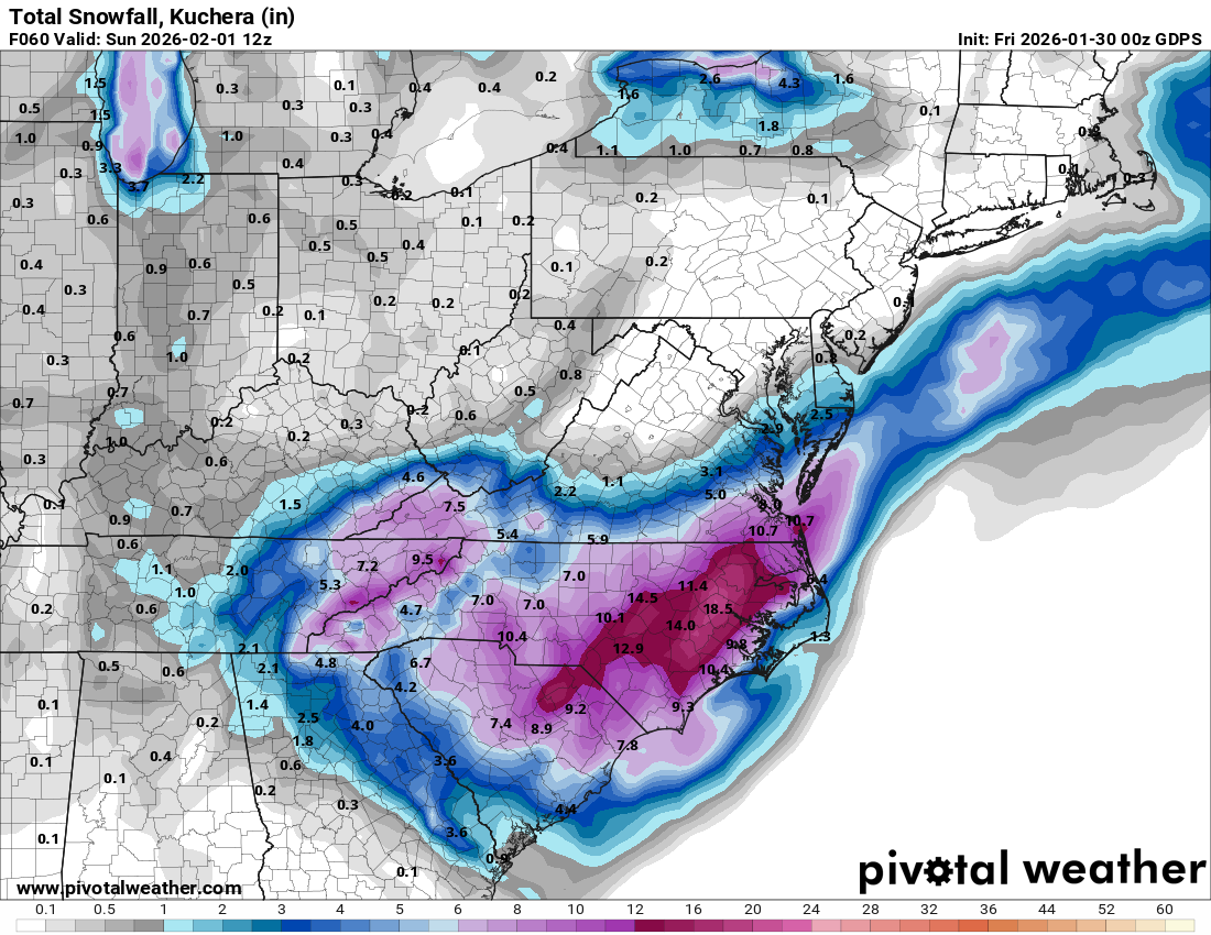
GFS also has a system
-
That period is looking more and more interesting..
-

The “I bring the mojo” Jan 30-Feb 1 potential winter storm
wncsnow replied to lilj4425's topic in Southeastern States
GFS had a stronger ULL which led to more expansive precip in the Western Carolinas. -
Best GFS run of the entire storm for us leeside folks
.thumb.png.891a0f4a8839efd78497b864cbb64b52.png)
-
Trended stronger with the ULL. We need it as strong as we can to maximize forcing and spin up that meso low
-
I think the short range is encouraging for us leeside/downsloping folks. The moisture trajectory is looking a little more SE/Easterly. We have to avoid the north or NW wind.
-
FV3 still looks solid. RRFS has the most precip minima now but has trended a little better
-
Pretty solid NAM runs. Upstate gets hammered. We need just a little push north.
-
Going with 2-3 inches here. Too much dry air showing up on the Hi Res models. Could even be a March 2009 bust with less than an inch directly in the Lee. Nam and HRRR keep getting worse not better.
-
The “I bring the mojo” Jan 30-Feb 1 potential winter storm
wncsnow replied to lilj4425's topic in Southeastern States
Improved too -
The “I bring the mojo” Jan 30-Feb 1 potential winter storm
wncsnow replied to lilj4425's topic in Southeastern States
I lived in Danville almost 4 years before moving back to NC. -
The “I bring the mojo” Jan 30-Feb 1 potential winter storm
wncsnow replied to lilj4425's topic in Southeastern States
Dang good storm also for a lot of folks -
The “I bring the mojo” Jan 30-Feb 1 potential winter storm
wncsnow replied to lilj4425's topic in Southeastern States
And still how many games out of the playoffs? -
The “I bring the mojo” Jan 30-Feb 1 potential winter storm
wncsnow replied to lilj4425's topic in Southeastern States
Blue Kazoo something. I remember it vaguely but many of us have been on here and the predecessor for 20 years now so it gets foggy. -
The “I bring the mojo” Jan 30-Feb 1 potential winter storm
wncsnow replied to lilj4425's topic in Southeastern States
Didn't he start a thread years back and it also was a good storm? -
The “I bring the mojo” Jan 30-Feb 1 potential winter storm
wncsnow replied to lilj4425's topic in Southeastern States
Canadian improved from earlier too
-
GFS looks good
-
The “I bring the mojo” Jan 30-Feb 1 potential winter storm
wncsnow replied to lilj4425's topic in Southeastern States
RDPS also big improvement. One trend I have noticed tonight is the ULL further west and slower -
RDPS increased again. Good sign IMO.
-
The “I bring the mojo” Jan 30-Feb 1 potential winter storm
wncsnow replied to lilj4425's topic in Southeastern States
Icon went nuclear -
But the Euro was farthest south and had highest totals for MBY.
-
I thought digging would help negate downsloping but now I'm not so sure
-
Meanwhile the regular nam looks amazing
-
It's weird because it looks like decent echoes on simulated radar for hours yet totals are meager. 2-4 generally for us despite decent returns. Dry air.
-
The “I bring the mojo” Jan 30-Feb 1 potential winter storm
wncsnow replied to lilj4425's topic in Southeastern States
Keep ticking west and that surface low will keep ticking west too


.png.aab4b3ca0c44b63184edfc9c1e055149.png)