

vastateofmind
-
Posts
1,949 -
Joined
-
Last visited
Content Type
Profiles
Blogs
Forums
American Weather
Media Demo
Store
Gallery
Everything posted by vastateofmind
-
As a lifelong Dolphins fan, who's been used to disappointment more than the alternatives...I approve of this assessment.
-
 I know it's in your profile name....but DUDE. You take THE MOST AWESOME pics, like EVER, in this entire sub. Probably in all of the AmWx subs. I so love your work. I aspire to your level of photographic skills (with my various Google Pixel phones). So for that....THANK YOU for sharing!!
 -
100% agree. Except our 26 year old son visiting from Austin is all, "Hey, let's go downtown and visit some museums and bars!!" And my wife and I are all, "DUDE, have you LOOKED OUTSIDE??"
-
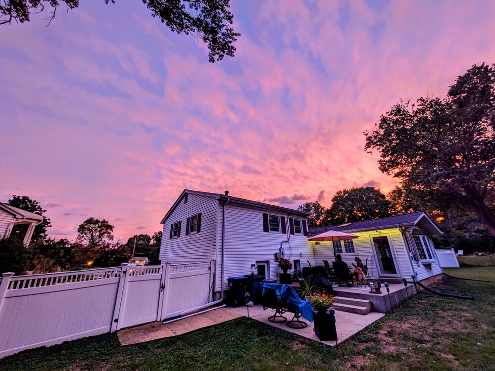
EXACTLY this...so very nice to have the windows open most of the evening! Also, this isn't as good as the rest posted earlier...but the "hurricane sunset" from our backyard earlier.
- 563 replies
-
- 11
-

-
I was just wondering about this...my family is bugging the crap out of me to start the wood firepit for a few hours before the rain arrives....but the rain looks to be pushing up from between RIC/FXBG right now? I'm thinking a firepit will need to be put out within an hour or two? #HELP Yeah, winds are noticeably stronger within past hour or so....gonna put on a sweatshirt.
-
Not cocktails -- not yet anyway! -- but Mrs. VAStOfMd made a Wegmans run and picked up some Southern Tier Warlock and Pumking beers for the weekend. Our absolutely TOP favorite autumn timeframe IPAs in the whole wide world.
-
Walked into the VA ABC store to browse yesterday...and was honestly surprised at all of the flavored options for whiskey now. I mean, there's been a lot of options for flavored vodka for sometime now, but WOW. I'm intrigued by your Jim Beam homebrew option...
-
Well then I am doubly happy for you all, if you've never visited MB! I think you will really enjoy the variety of eating and entertainment options, and if you're seeing family...ALL the better!
-
But...if y'all leave early enough, you SHOULD clear the worst effects of Ophelia by midday to mid-afternoon. I mean...it WILL suck with windshield wipers doing double-speed, at least some of the time. But just remember the prize that awaits you at your destination...and enjoy. My wife and I are heading to MB the week of Thanksgiving, to make some of our final "neigborhood shopping" decisions, prior to a final move there in the next 1-2 years. We've been making that Thanksgiving week trip for the past several years and as always...CAN'T WAIT.
-
There's no other member on this board than @Scraff (well, @CAPE, too) when the power fails, and we NEED to empty out the beer fridge before it all gets warm...or, alternately, transfer it to the ice chests.... That is a REAL pretty sat pic right there. So, for those who were here back then...does Ophelia fall just short of being as impactful as Isabel in 2003 in terms of rain or wind? Or not even close? I've seen a few historical charts that showed Isabel dropped 1"-3" in the metro area, but the winds (I think, or at least remember) definitely had in impact in the area.
-
User name checks out... Now getting wind advisory for my neck 'o the woods. Interesting.
-
Things heating up down there at the Frying Pan Shoals Light...
-
That's it! I saved the label, too...just can't remember where I put it.
-
I was thinking earlier that you live in a spot that might get a good show out of the incoming storm...
-
Damn! That's tall! And now that you've mentioned that, I've got a couple butterfly bushes on the front of the house almost that tall that are gonna be laid out flat tomorrow between rain/wind, if I don't shore THEM up somehow. The forecasted northern reach of the wind field, which someone also mentioned a page ago last evening, is impressive.
-
Yeah, forecasting on Baby Ophelia has been pretty solid for the past 24-36 hours, just did a lot of catching up on NHC's discussions and graphics. It does indeed read like we're going to have some moderate impact here in the metro areas. Between lurking here, finishing some taskers at work, and squeezing the weekly mowing in...gonna be a busy day!
-
Ocelot is one of my favorite local brewers....one of their best recent offerings was an excellent IPA collab with Solace (another awesome local brewer) last year, for which they secured the rights to use the images of Sterling Archer and one of his regular nemeses, Babou the Ocelot, on the can label...
-
And, typically in your case, @CAPE -- a DAMN fine selection if IPAs to choose from, if said rainy weekend decides to materialize...
-
That was about the max speed I could drive the six-mile long commute to Fort Belvoir from my house this morning around 0615....driving rain in which you couldn't see across the street. My typical 12 minute commute took 25-30 min. Most streets on post were flowing with several inches of water, and I'm sure I ruined a pair of loafers attempting to cross one. Don't know how much rain NoVA got between about 0600 and 0730...but it HAD to be inches.
-
We saw similar cloud/potential contrail phenomena on at least two occasions on our trip across the southwest U.S. over the past two weeks....once in Oklahoma, and again in the Grand Canyon area. It was...weird/interesting.
-
2023 Mid-Atlantic Severe Wx Thread (General Discussion)
vastateofmind replied to Kmlwx's topic in Mid Atlantic
Wow, STW just issued....didn't expect that for this afternoon, thought we'd have maybe slightly stronger than usual storms. -
Yeah, the ramp-up in intensity is amazing. Don't think I've seen a hurricane blow up that nasty in such a short amount of time.
-
THAT sounds like an incredible trip! I've always wanted to take an Alaskan cruise. My wife and I (and our yellow Lab!) just returned from a two-week, out-and-back road trip across the southwest to the Grand Canyon. As most of you already know, it's been heatwave mode in the midwest and southwest for a few weeks now...most days in all of the cities we visited (including the Grand Canyon area) ranged between low/mid 90s to low 100s (was 109 when we pulled into OK City last week)...but it was otherwise clear and sunny the entire time, with exception of five minutes of light raindrops from a passing shower in Santa Fe last week. I still can't believe our weather luck held out that well for two whole weeks. We enjoyed it so much, we're going to take the more northwesterly version of that road trip to Yellowstone National Park next year.
-
Sooooo....the haziness today, is there ANOTHER round of wildfire smoke coming from somewhere overhead today? I swear I could smell it a bit when I left Fort Belvoir over an hour ago. And, well...I'm thinking that we probably could've planned our two-week long (staring in two days) trek through the southwest U.S. to the Grand Canyon, and then back to NoVA, a little bit better. But we'll do okay...just need to dress lighter.
-
Preach. We love to visit downtown Frederick...in point of fact, I prefer it over the overcrowded and overrated Old Town Alexandria, all day every day. We just hate getting to Frederick from NoVA, which is nearly always a tremendous pain in the ass, no matter if you leave early morning, midday, or mid afternoon on a weekend day. I-270 = HELL.


