

mreaves
-
Posts
14,917 -
Joined
-
Last visited
Content Type
Profiles
Blogs
Forums
American Weather
Media Demo
Store
Gallery
Everything posted by mreaves
-
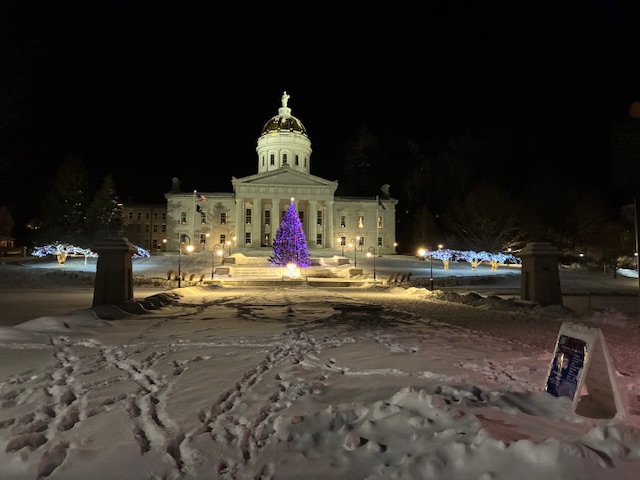
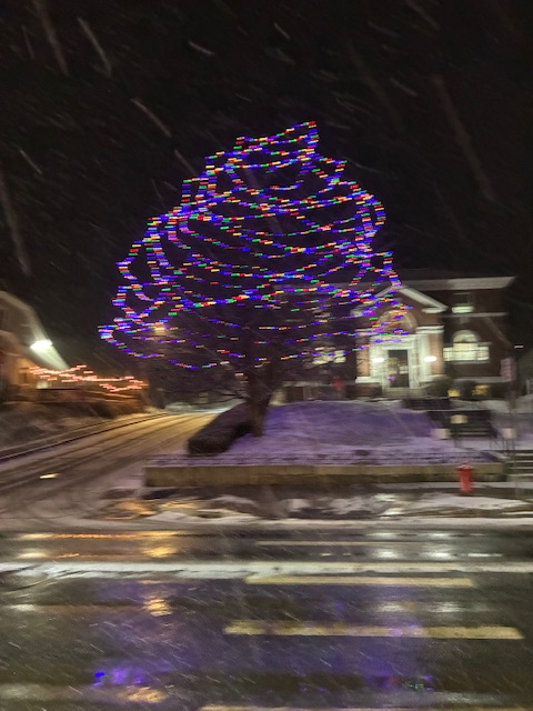
The State House in Montpelier is looking nice.
-
I did not think it was going to snow on and off all day. Not as much as in the mountains, maybe an inch. If only we hadn’t had that friggin’ crap last week.
-
-
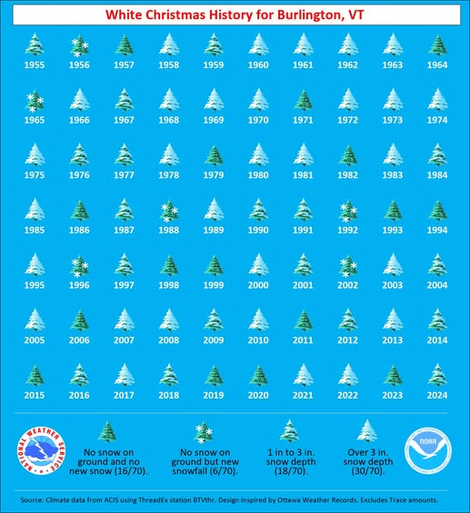
Neat graphic from BTV
-
I even included SLK for @WxWatcher007 ...Vermont... ...Addison County... Starksboro 4.4 ENE 5.5 in 0900 AM 12/24 COCORAHS Bristol 3.1 in 0700 AM 12/24 COOP Middlebury 0.3 N 3.0 in 0700 AM 12/24 COCORAHS New Haven 2.4 SE 3.0 in 0800 AM 12/24 COCORAHS Vergennes 2.8 in 0428 AM 12/24 COOP Shoreham 3.5 NNE 2.5 in 0800 AM 12/24 COCORAHS ...Bennington County... 5 NNW Londonderry 7.7 in 0713 AM 12/24 Peru 1.3 E 4.0 in 0700 AM 12/24 COCORAHS Bondville 2.4 WNW 3.0 in 0738 AM 12/24 COCORAHS Manchester 1.8 SSW 2.7 in 0730 AM 12/24 COCORAHS Manchester Center 0.9 NE 2.5 in 0830 AM 12/24 COCORAHS Manchester 2.8 ENE 2.2 in 0700 AM 12/24 COCORAHS Manchester Center 2.3 NE 1.5 in 0700 AM 12/24 COCORAHS Bennington 1.2 in 1100 PM 12/23 Trained Spotter North Bennington 0.8 in 0900 AM 12/24 COCORAHS North Rupert 1.7 WNW 0.5 in 0700 AM 12/24 COCORAHS Bennington 0.6 SE 0.4 in 0730 AM 12/24 COCORAHS Bennington 0.7 SE 0.1 in 0800 AM 12/24 COCORAHS ...Caledonia County... Wheelock 1.6 S 5.9 in 0700 AM 12/24 COCORAHS East Hardwick 0.4 SE 5.8 in 0900 AM 12/24 COCORAHS Lyndonville 1.1 W 5.3 in 0830 AM 12/24 COCORAHS Sutton 5.0 in 0850 AM 12/24 COOP 1 NW Lyndonville 5.0 in 0854 AM 12/24 Public Wells River 2.1 WNW 4.8 in 0656 AM 12/24 COCORAHS Barnet 3.5 W 4.0 in 0730 AM 12/24 COCORAHS ...Chittenden County... Underhill 4.4 NNE 5.8 in 0700 AM 12/24 COCORAHS Huntington 6.5 S 5.5 in 0800 AM 12/24 COCORAHS Huntington 1.1 E 5.1 in 0700 AM 12/24 COCORAHS Williston 0.2 WSW 5.0 in 0700 AM 12/24 COCORAHS Underhill 5.1 NNE 5.0 in 0700 AM 12/24 COCORAHS Underhill 3.6 ESE 5.0 in 0745 AM 12/24 COCORAHS 2 NW Westford 5.0 in 0806 AM 12/24 NWS Employee Colchester 4.9 in 0729 AM 12/24 NWS Employee Nashville 1 E 4.6 in 0645 AM 12/24 COOP 1 SE West Milton 4.5 in 0756 AM 12/24 NWS Employee 1 ENE South Burlington 4.5 in 1000 AM 12/24 Official NWS Obs Hinesburg 0.9 N 4.4 in 0829 AM 12/24 COCORAHS Shelburne 0.5 ENE 4.2 in 0700 AM 12/24 COCORAHS South Burlington 2.6 SSW 4.0 in 0800 AM 12/24 COCORAHS Burlington 3.8 NW 3.6 in 0800 AM 12/24 COCORAHS Huntington 1.6 SW 3.5 in 0700 AM 12/24 COCORAHS ...Essex County... Lunenburg 2.3 NNW 7.5 in 0530 AM 12/24 COCORAHS Island Pond 5.0 in 0810 AM 12/24 COOP ...Franklin County... Enosburg Falls 2.5 N 5.1 in 0730 AM 12/24 COCORAHS 1 ESE Saint Albans 4.7 in 0833 AM 12/24 Public Montgomery 4.1 ESE 4.5 in 0700 AM 12/24 COCORAHS Enosburg Falls 4.4 in 0841 AM 12/24 COOP Swanton 0.5 NNE 4.0 in 0700 AM 12/24 COCORAHS ...Lamoille County... 1 SSE Smugglers Notch 6.8 in 0906 AM 12/24 Public Johnson 2 N 6.0 in 0700 AM 12/24 COOP Morrisville 6.0 in 0836 AM 12/24 Public 2.5 N Smugglers Notch 5.5 in 0730 AM 12/24 COOP Stowe 0.2 SW 5.2 in 0730 AM 12/24 COCORAHS Jeffersonville 1.3 SSW 4.5 in 0700 AM 12/24 COCORAHS ...Orange County... Braintree 2.8 SW 5.0 in 0800 AM 12/24 COCORAHS Williamstown 3.0 WSW 4.7 in 0700 AM 12/24 COCORAHS 2 NE East Brookfield 4.5 in 0917 AM 12/24 Public Bradford 2.2 NNW 3.8 in 0500 AM 12/24 COCORAHS 2 SE Strafford 3.8 in 0700 AM 12/24 COCORAHS 1.5 E Corinth Corners 3.8 in 0700 AM 12/24 COOP West Fairlee 1.8 ENE 3.6 in 0700 AM 12/24 COCORAHS Fairlee 3.0 in 0856 AM 12/24 Public ...Orleans County... Greensboro 3.9 NNE 7.2 in 0730 AM 12/24 COCORAHS Greensboro 2.1 NNW 6.0 in 0700 AM 12/24 COCORAHS Craftsbury 1.6 SSW 6.0 in 0730 AM 12/24 COCORAHS Craftsbury Common 5.8 in 0700 AM 12/24 COCORAHS Westfield 0.8 WNW 5.5 in 0700 AM 12/24 COCORAHS Morgan 6.7 SE 5.5 in 0800 AM 12/24 COCORAHS Derby Line 1.9 W 5.0 in 0700 AM 12/24 COCORAHS Brownington 4.7 ESE 4.8 in 0800 AM 12/24 COCORAHS ...Rutland County... Shrewsbury 0.8 W 3.8 in 0700 AM 12/24 COCORAHS Rutland 1.2 N 2.6 in 0700 AM 12/24 COCORAHS 1 N Rutland 2.6 in 0700 AM 12/24 COOP West Rutland 1.2 N 1.6 in 0615 AM 12/24 COCORAHS Wallingford 2.7 SSW 1.6 in 0700 AM 12/24 COCORAHS West Rutland 0.9 SSE 0.9 in 0800 AM 12/24 COCORAHS ...Washington County... 3 SSW Woodbury 8.0 in 0826 AM 12/24 Trained Spotter Waterbury 3.0 NW 7.3 in 0600 AM 12/24 COCORAHS 3 SSE Moscow 6.5 in 0626 AM 12/24 Trained Spotter 1.6 W Worcester 6.2 in 0700 AM 12/24 COOP Woodbury 3.4 NNW 6.0 in 0700 AM 12/24 COCORAHS Montpelier 1.7 NE 5.0 in 0700 AM 12/24 COCORAHS Warren 2.8 E 5.0 in 0700 AM 12/24 COCORAHS East Montpelier 4.8 in 0730 AM 12/24 COCORAHS 1 SW East Barre 4.4 in 0459 AM 12/24 NWS Employee Plainfield 1 ESE 4.0 in 0700 AM 12/24 COOP ...Windham County... Westminster 5.5 W 5.8 in 0700 AM 12/24 COCORAHS Londonderry 3.5 E 5.3 in 0700 AM 12/24 COCORAHS Jamaica 1.9 WNW 4.0 in 0715 AM 12/24 COCORAHS Wilmington 0.6 WNW 3.0 in 0658 AM 12/24 COCORAHS Westminster 5.5 NW 3.0 in 0700 AM 12/24 COCORAHS Rockingham 1.1 NNE 2.8 in 0700 AM 12/24 COCORAHS East Dover 1.8 N 2.2 in 0630 AM 12/24 COCORAHS Brattleboro 1.3 WSW 2.2 in 0700 AM 12/24 COCORAHS 5.6 W West Brattleboro 2.0 in 0800 AM 12/24 COOP Rawsonville 0.9 NE 2.0 in 0700 AM 12/24 COCORAHS Marlboro 2.0 NNE 2.0 in 0800 AM 12/24 COCORAHS Putney 0.7 NE 1.8 in 0800 AM 12/24 COCORAHS Brattleboro 0.7 S 1.6 in 0645 AM 12/24 COCORAHS Guilford 7.0 SW 1.5 in 0730 AM 12/24 COCORAHS East Dummerston 0.5 NE 1.5 in 0800 AM 12/24 COCORAHS ...Windsor County... 4 NE West Hartford 5.3 in 0700 AM 12/24 Public 1 NNE Pomfret 5.2 in 0900 AM 12/24 Public Ludlow 3.4 S 4.5 in 0700 AM 12/24 COCORAHS Andover 2.5 NW 4.5 in 0700 AM 12/24 COCORAHS 3 S Ludlow 4.5 in 0850 AM 12/24 Cocorahs Rochester 1.7 NNE 4.0 in 0515 AM 12/24 COCORAHS 1 ESE Weston 4.0 in 0700 AM 12/24 COCORAHS 0.6 E Woodstock 4.0 in 0800 AM 12/24 COOP Proctorsville 0.3 NNE 3.6 in 0700 AM 12/24 COCORAHS Chester 3.0 WSW 3.3 in 0700 AM 12/24 COCORAHS ...New York... ...Franklin County... Saranac Lake 6.2 N 5.8 in 0707 AM 12/24 COCORAHS 0.9 W Malone 5.0 in 0700 AM 12/24 COOP
-
Looks like 5.5" will do it. That includes the .5" or so from the Monday snow. A little bit of an over performer.
-
OT but we spent a weekend in that general area at Sebasco Harbor last summer.. Beautiful area. Loved Popham Beach.
-
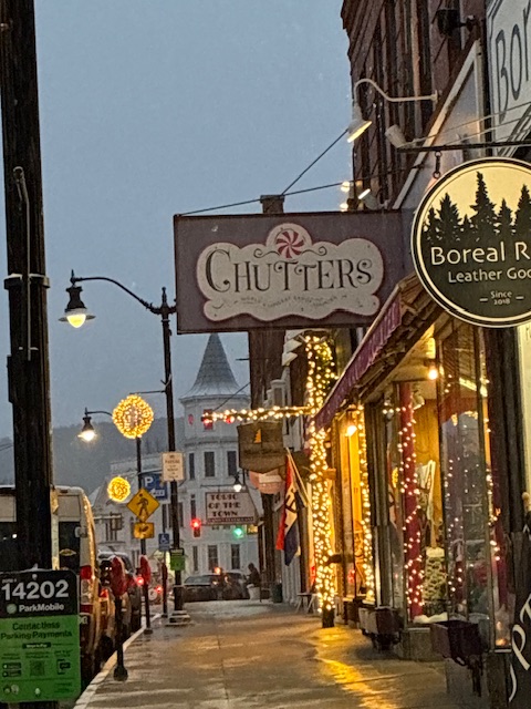
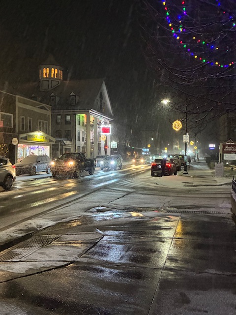
Measured 4” but that includes the little bit that fell yesterday. Went over to Littleton, NH to finish up Christmas shopping. Very festive. Rt. 302 was crap on the way home.
-
I'm ready baby!

-
Every time I see North Haven mentioned, I am reminded of the time that DIT tried to convince all of us that most people knew that NH meant North Haven and not New Hampshire.
-
-
Here is the latest map from BTV
-
That’s the feeling I’ve been getting too. We obviously haven’t had the accumulation the mountains have but it’s seems to snow at any opportunity.
-
1977. Maybe my favorite Christmas song.
-
Maybe I just missed it but I didn’t really expect snow today. Maybe half an inch?
-
It’s dropped down to us. It’s a raging mini blizzard out there right now.
-
Lol. Your area and right over @powderfreak’s head.
-
So be it then. I’d be fine with that.
-
Why is South Dakota highlighted?
-
DIT just made a mess in his dungarees.
-
Ha! A lot you know. Moose don’t have dens!
-
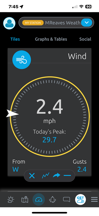
The wind was just about as strong as I’ve seen today. I spent most of the day in a conference room at the Waterbury State Office Complex with a wall of windows staring directly down the Winooski valley in JSpin’s general direction. The wind felt like it was shaking the windows and it pushed rain water in. My PWS recorded its highest gust ever at 29.7 mph. Sucks to have lost such a nice beginning but it’s snowing now.
-
My PWS is poorly sited for wind. It’s too close to the house and gets blocked from several directions. All that said, this is the strongest wind I’ve measured since I’ve had it, almost 30 mph.
-
Should have spent a little less.
-
This was Islanders Pond, VT yesterday. You don’t have to watch the entire video lol. Very nice for opening day. And I had to work


