

Tatamy
-
Posts
2,585 -
Joined
-
Last visited
Content Type
Profiles
Blogs
Forums
American Weather
Media Demo
Store
Gallery
Everything posted by Tatamy
-
Road trip to Cape May tomorrow night?
-
FWIW the 12z GEFS had 5 members with good to big hits to the north and west of I95 and 2 members with hits from the city S and E. Another member covered the whole area. I backed out the output from what I believe will be a non event Sunday night for this forum. This is from the Dupage website which shows outputs from 20 members.
-
GFS goes from a cutter at 0z to an inland runner at 6z to a DT special at 12z for the end of week potential event. These types of outputs reinforce the argument about how far out these OP runs should go.
-
I enjoyed reading his short term AFDs back in those days especially when a Coastal storm was in the offing. It was required reading for me first thing in the morning to read those AM Taunton AFDs.
-
I experienced this storm on LI. 30” fell where I was on the north shore of the island. What I remember about it was the number of hours that the visibility was consistently 1/4 mile or less. They had to use payloaders through the duration of the storm to clear the streets . I did not see something like that until 2016 when we had the same amount where I live in eastern PA. Visibility wise that one was not as spectacular however it did the job.
-
Yes it did.
-
Those were lean years back in the 70s and 80s however you did get an unexpected snowstorm on 12/6/81 that dumped 16-24” from Boston to Providence.
-
I was around for that one (PD1). I was living on the north shore of LI at the time. We did get snow for that- 7” worth with more in NYC and Jersey. The kicker for that one was a large part of LI Sound was frozen over. Like east facing coastal areas in NE we would get a bump in accumulations with storms that have a low level flow from the E and NE. With the frozen coastal waters our totals were cut in addition to what resulted from the synoptic setup.
-
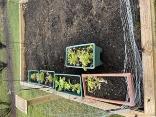
You don’t have to wait until spring in order to obtain produce from your garden. I have lettuce and parsley growing in mine right now. They are quite hardy and will withstand cold temperatures. I have been down to 17 with calm winds and our plants are fine.
-
 For those following this event on the models there have been large differences in the placement of the expected snow accumulations. In any case at this time there is steady snow falling in places primarily to the south and west of Harrisburg and State College. Radar shows the area of heavier precip in that area. The echoes to the north and east of there are primarily virga. What is interesting right now is moderate to heavy snow coming down in a burst in some places to the SW of Harrisburg along I81. In particular I just saw a visibility of about 1/4 mile near Chambersburg.
 -
Light Snow/Graupel mix here. 0.5” new. 28*
-
0.12” overnight. No ice here however all surfaces are wet. 32*
-
Light drizzle here with 33.
-
Two days in a row with temps in the teens. 18 yesterday and 19 this morning.
-
Strongly agree. GFS in particular is flopping around like a big fish thrown out of the water.
-
Cold front is through here. Wind gust to 43 mph during the past hour. High temperature of 64. Now down to 50.
-
Getting some mood flakes out here with those echoes crossing eastern PA and western NJ.
-
Ant - you are too dedicated to this process (I have been tracking it nonstop as well all the while it has been circling the drain so to speak on the models). We will get our chances this winter however this is not it.
-
Those echoes across eastern PA are all Virga at this time. I checked traffic cams in the area and nothing is reaching the ground. One report of snow from the Reading area on mPING. Amounts to zippo look good…
-
I think that might be stretching it a bit. I am up in that area a couple of times a week at least and most of the time the ground is bare. The last time when I was up there and saw snow was about a week ago.
-
These strong winds will be going on for a while. I just had my highest gust of the night at 38 mph.
-
Walt has already posted about the potential for strong winds with the cold front passage this evening. I am seeing that occurring right now in places just west of Allentown on stations that report on WU and the Davis Network. Wind gusts to 30mph on these types of stations will translate to gusts up to and over 40 mph at the NWS reporting stations. Mt. Holly has already issued a SWS for this threat for my area.
-
On the 18z GEFS 10 / 20 members are biting on this one for the NYC region. 8 / 10 are 6”+ for at least part of the metro area.
-
Interesting dataset off of the 12z GFS at 210 hours: No support in the ensembles for it.
-
06z GEFS also has a lot of members showing this. The best probabilities continue to lie to the north and west. As Walt indicated this will be primarily an I84 type event.


