

Tatamy
-
Posts
2,032 -
Joined
-
Last visited
Content Type
Profiles
Blogs
Forums
American Weather
Media Demo
Store
Gallery
Posts posted by Tatamy
-
-
1 hour ago, romba said:
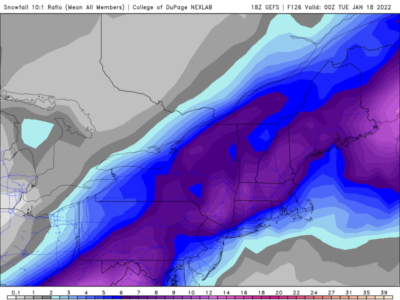
Difference in maps is the resolution? Algorithm? Does the bottom one show sleet as snow? Bottom seems to have been smoothed out and shows Central Jersey for example as 10-12 and top one shows it as 4-6. Pretty big difference in map totals....
The top map with the higher amounts to the north was from the College of Dupage website. On their website they state that the data presented is downloaded directly from the NCEI servers. It uses a 10:1 ratio to calculate snow amounts. We all know that these clown maps have their limitations and that actual ratios that occur will vary from place to place. WRT to SV I will leave that up to you to determine the validity of the data presented.
-
 1
1
-
-
4 minutes ago, Rjay said:
The gefs are sooo much better than the 12z run for our subforum.
What is most interesting is how the model is struggling to resolve the UVVs that are taking place across eastern PA and NW NJ in the area of heaviest precip. Very dynamic system.
-
 2
2
-
-
-
21 minutes ago, Jt17 said:
To my untrained eye this looks like the euro ensemble is taking a similar track to what it had at 00z? And based on the 850 temps at this frame it would actually be snowing at hour 120. Perhaps there's some hope the OP models have completed their west trend and might wiggle back east a bit. Still too early to give up on that possibility IMO.
Precip type with this one will have to do with temperatures at all levels of the atmosphere, not just 850mb. If you picked up somewhere that temperatures at or below 0 at 850mb means that you are golden for snow - you are badly mistaken. There will be CAD inland initially with this storm and that means that precip that starts as snow will go to sleet and or ice before going to rain in many places. As currently modeled the coast will be primarily rain (as of now). As we all know the forecasts for this storm have been subject to big changes with each model run. To determine precip type for your location you would need to check a sounding for your specific location.
-
12z GFS at 117 hrs. Again this would result in tropical storm force winds along coastal areas. Period of highest risk would be Monday.

-
2
-
-
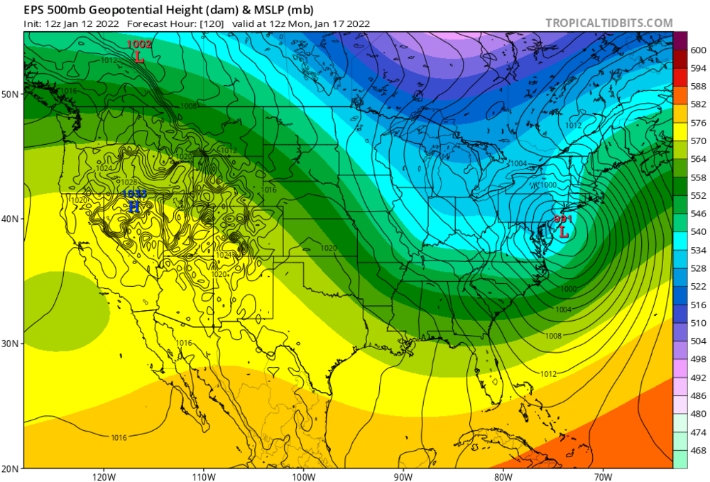
12z Euro at 120 hrs. If this verifies you will have tropical storm force winds along the Jersey shore, NY harbor, and along the south shore of LI.

-
1
-
-
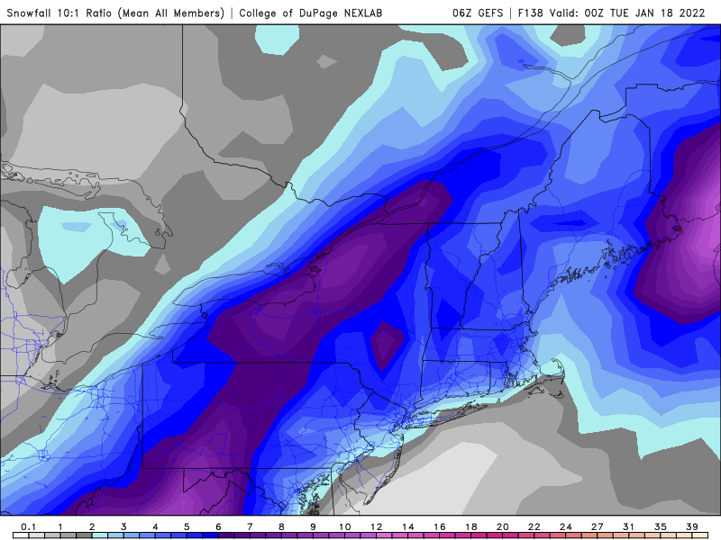
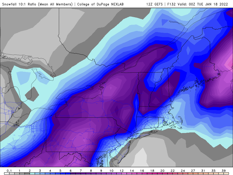
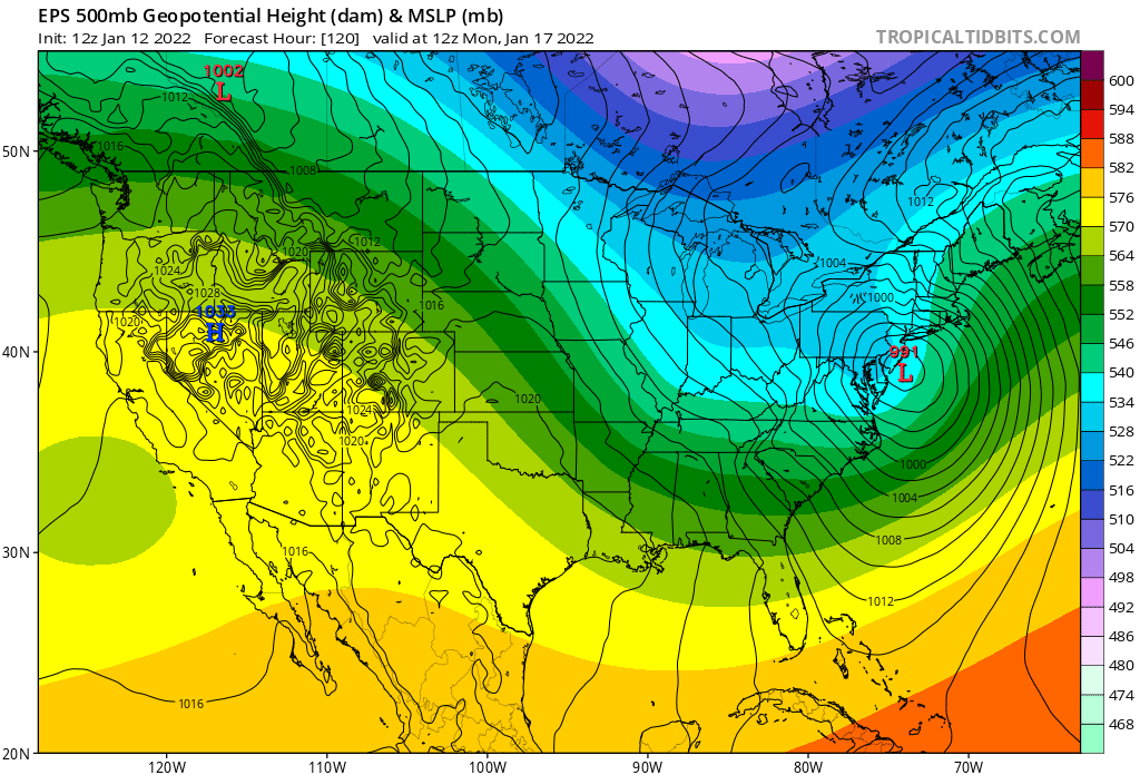
Here is the ensemble mean snowfall (GEFS) estimates for this system for 6z and 12z.
6z
12z
-
1
-
-
12 minutes ago, Tezeta said:
Anyone know some good webcams from the tri state where I can watch the snow? I’m trying to get my bookmarks together so I don’t have to figure it out in the heat of the moment…
Go to the state that you are interested in and lookup the DOT website for it. It will provide a link to highway webcams on the major roads.
-
1
-
-
26 minutes ago, Brian5671 said:
with a phased storm cutting or our west we'd have strong E or ESE winds off of 45 degree oceans-that cold air won't stand a chance....
I my original post I was referring to areas well inland away from the coast. As modeled there is a fair amount of sleet and freezing rain associated with this storm in those places. Strongly agree that the strong easterly or SE flow will kill chances for freezing/frozen precip near the coast.
-
7 minutes ago, MJO812 said:
Gefs clearly west of 0z

Ensemble mean now has the axis of heaviest snows up through the central appalachians. OP is really leading the way on this one.
-
2
-
-
1 minute ago, MJO812 said:
Gefs more amped
I thought the pattern would be conducive for a nice coastal storm. I guess wrong.

This is morphing from a coastal to an inland runner to an apps runner - and it’s not done yet. The part that remains somewhat interesting is the CAD ahead of the storm east of the spine of the appalachians. Whether this continues and to what degree is an open question.
-
1
-
-
17 minutes ago, MJO812 said:
Gfs is even more west
Brings rain almost to Pittsburgh… lol
-
 1
1
-
-
28 minutes ago, SnowGoose69 said:
Even verbatim the Op Euro would produce massive front end snow to the coast...the air mass in place ahead of it is fairly cold despite the high exiting. Models at this range in such setups as that will never resolve thermals correctly...you'd hold a 040-050 wind for an extended period there with snow and would not flip over til the 850 low was almost here.
If you look at the boundary level on the 12z Euro at 10m you will have a stiff easterly flow across LI and along the Jersey shore. Ocean temps are in the upper 40s which is 5-8 degrees above normal for this time of the year. That will not hold the cold air in those coastal areas. The ageostrophic flow which will be present just inland with the vector you described will hold that cold air at least for a time there. I do not see massive front snow to the coast with this run. In any case it’s all hypothetical at this point anyways.
-
2
-
-
4 minutes ago, Rjay said:
Eps is going to be well east of the op too.
On the 12z GEFS only 3 of 20 members were solid inland runners. The others brought heavy snows to the coast and inland or there was no storm at all. Way too soon to rule out anything.
-
1
-
-
18 minutes ago, MJO812 said:
Wow that's impressive
Walt just nailed the 12z NAM.
-
2
-
-
1 minute ago, MJO812 said:
This is why you don't give up on anything a few days out
That is what I was alluding to yesterday. There have been consistent hints in the ensembles about the potential built into this pattern. It’s a matter of the models figuring this all out. Now that the lead system (coastal going OTS late in the week) is getting out of the way they are starting to move closer towards a solution.
-
3
-
-
06z GFS with deep tucked in SLP. Another big hit especially for the areas N and W.
-
2
-
-
2 minutes ago, Irishmick9 said:
Picked up an inch in that line up here in Vernon
I have been seeing the same thing on traffic cams across NE PA for the past couple of hours. It is a quick hitter but it’s fierce as it moves through with very low visibilities.
-
1
-
-
8 minutes ago, eduggs said:
Yeah I was hoping they would hold together but the line has largely dissipated. Still could be a few squalls here and there.
These are low topped. The radar doesn’t show the full extent of these due to their distance from the sites at Fort Dix and BNL. I was looking at white outs on traffic cams back in NE PA along I80 mean while the radar showed virtually nothing.
-
2
-
-
FWIW while everyone is watching the threat for next week don’t forget the snow showers and squalls moving down from the N and NW across the Poconos, NW NJ , and SE NY at this time. They are starting to move in to the range of local radars. They are producing locally heavy bursts of snow as they move through.
-
3
-
-
9 minutes ago, LibertyBell said:
Looks like my other home is going to get a nice snow squall
Yes it does. The squalls moving into the Scranton area are quite potent right now.
-
1
-
-
57 minutes ago, wdrag said:
In the meantime, do not be surprised to see a a band of snow showers, a few with SW+ thru the 184-I80 corridors into NYC-LI between 10P-3A. Think it's forming on BGM radar at 01z, with excessively steep low lvl moist lapse rates, a slight wind shift to NNW behind the band with much more stable air arriving at sunrise (and with the more notably falling temps-unsure if anyone noticed the 6C drop in BL temp between 06z and 12z on the NAM FOUS).
Hopefully I was up to a dusting. Some places might get 1/2-1" fluff?
Will rereview Thu night-Fri, Sunday centered snow opportunities tomorrow morning.
A peak at a webcam along I81 north of Scranton shows this activity is still very healthy. Visibility at this location (MM206) looked to be 1/4 mile or less. Radar up there looks good. Latest run of the HRRR (01z) indicates this activity could drop up to 1/2” across NE PA and far NW NJ and adjacent SE NY down towards the Cuomo Bridge.
-
1
-
-
2 hours ago, MJO812 said:
Can we get through this favorable period first before posting doomsday posts.

-
1
-
 1
1
-
-
Just now, Tatamy said:
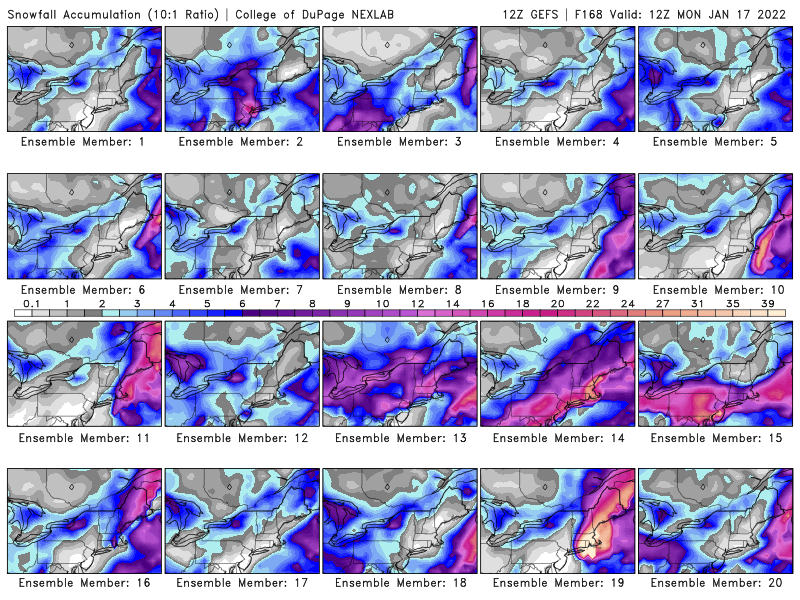
As shown above the models do not have a handle on what will be happening next weekend. These are the 12z outputs from the GEFS.

East coast storm targets our subforum Noon Sunday-3PM Monday 1/16-17/22 with significant impact potential for heavy snow/heavy rain, a period of gusts 45-60 MPH along the coast with possible coastal flooding Monday morning high tide.
in New York City Metro
Posted
Catskills