

Tatamy
-
Posts
2,571 -
Joined
-
Last visited
Content Type
Profiles
Blogs
Forums
American Weather
Media Demo
Store
Gallery
Posts posted by Tatamy
-
-
3 minutes ago, LVblizzard said:
That’s what I suspected too. The flashes were on the horizon and none of them lit up the whole sky. I’m not sure I’ve ever seen that around here, especially 3 times in 2 minutes like I just did.
I saw exactly what you did. It’s not common and there is already reports on social media of power outages. It relates to where these downbursts occurred.
-
I am observing power flashes with this line just west and SW of me near Bethlehem. This is not lightning.
-
Reached 82 here. Liking this May in March weather.
-
 1
1
-
-
-
Storm total here in Bethlehem Twp. is 5.3”
-
Now up to 4” new in Bethlehem Twp. 30/29
-
Measured 2” new in Bethlehem Twp. 30/29z
-
1” new. 30/29. Moderate snow.
-
1
-
-
Moderate snow - Visibility 1/2 mile. 32/31
-
19 minutes ago, LVLion77 said:
I do not think it is unreasonable to be highly skeptical of the NWS forecast for the Lehigh Valley. 10-20” is wishcasting. 4-8” is much more reasonable in my opinion.
They’re in a tough spot as the models have been all over the place. They use the NBM which is a weighted model containing most all of the other models outputs ( It’s like a mean of the other model projections). Because of how it works there is a delay in terms of it not recognizing the newest data. Incidentally your number seems reasonable to me.
-
1
-
-
7 minutes ago, RedSky said:
Light rain has started to change to snow
35F
I’m observing that as well. My temp has also dropped to 35.
-
30 minutes ago, Lucy Pull said:
I’m definitely ready to hallucinate that band pivoting into northwestern Northampton county…feel that I’m just too far here.
I’m trying to that with that heavier band near Trenton that is struggling to move NW. Not working out too good.
-
8 minutes ago, Ralph Wiggum said:
Temp up to 37 here from 34 a few hours ago. Flakes stopped mixing at 945am and has been all rain ever since. Steady rain attm.
Same here.
-
Just now, psv88 said:
88 in Miami Beach
You’re in a better place. Enjoy!
-
Light rain 36/33
-
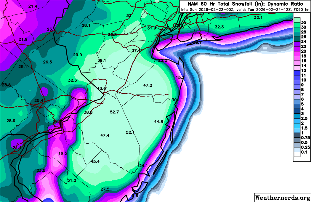
47 minutes ago, Tatamy said:
It’s an interesting forecast where I am near the Delaware River with only the short term Mesos calling for big snows here (12-18”) whereas the globals and some mesos are calling for 8-12”. The IVT will be the key out here for me and other NW areas. The cutoff will be right through my general area I believe.
12z HRRR concurs with the Delaware River cutoff for the big snows.
-
 1
1
-
-
Steady light snow. Visibility 3 miles. 33/31
-
1
-
-
57 minutes ago, SnoSki14 said:
It'll be there but the caveat is an inverted trough will be in place which could enhance totals on the western flank and lead to much less sharper cutoffs than we'd normally see.
In addition I expect the strongest banding to be NW of where models have them as is almost always thr case.
It’s an interesting forecast where I am near the Delaware River with only the short term Mesos calling for big snows here (12-18”) whereas the globals and some mesos are calling for 8-12”. The IVT will be the key out here for me and other NW areas. The cutoff will be right through my general area I believe.
-
1
-
-
Regarding the output from the RDPS, it’s similar to the run at 12z. This is the CMC ensemble run from 12z. If someone can explain the difference between these I would be interested to know.

-
2 minutes ago, jdt said:
The 3k is picking up on local topography on NWNJ. The band is over western edge of NNJ highlands region. The lighter band to west is kittatinny ridge
.Orographic lift
-
3
-
-
3 minutes ago, wthrmn654 said:
I have access to multiple davis weather stations with good wind sensors.. montauk lighthouse, that had 81 mph gust this fall/ early winter, cross sound ferry, and possibly work weather station.
I own one on Fire Island.
-
1
-
-
8 minutes ago, MANDA said:
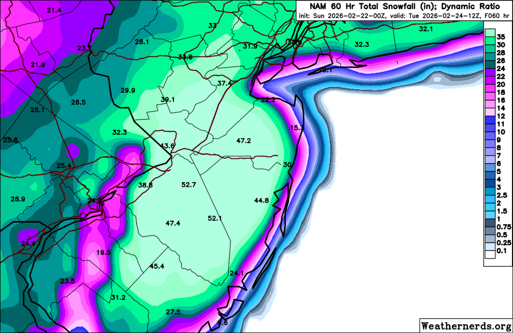
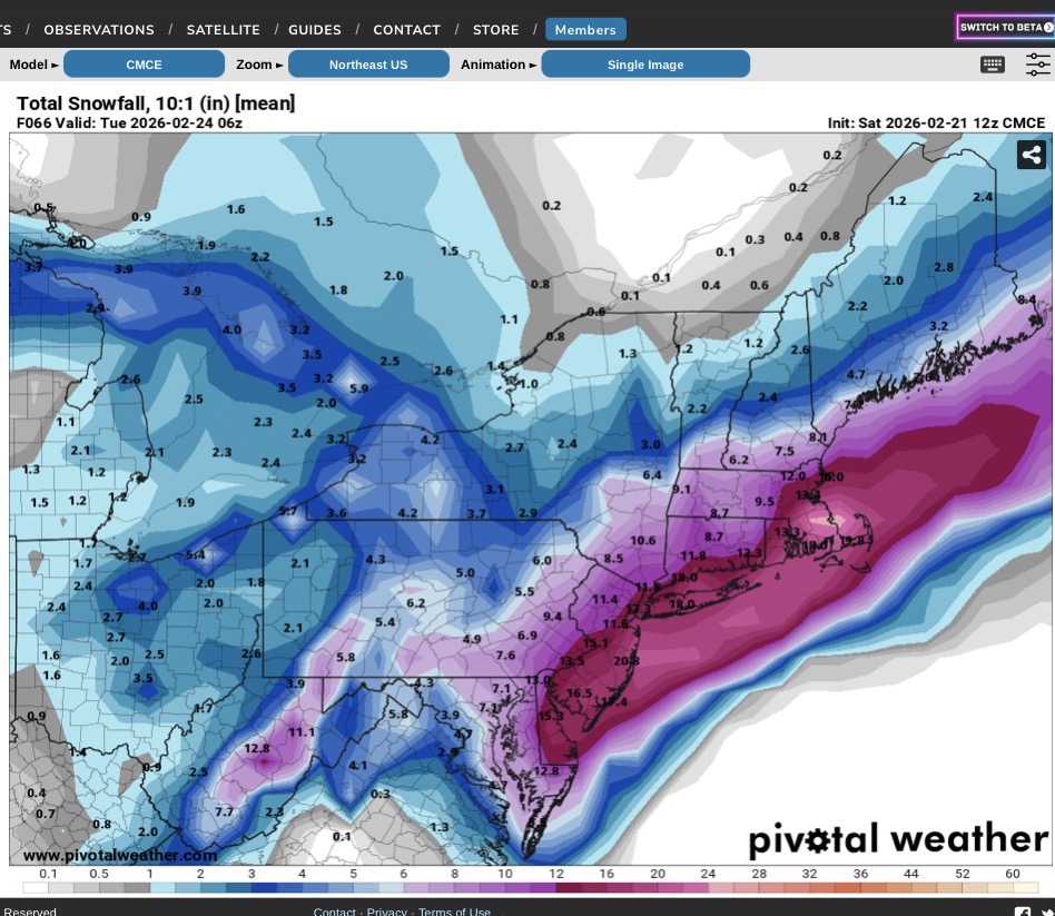
Not endorsing the amounts by any means. Interesting though that the NAM, SREF and HRRR have been targeting these two areas for several consecutive runs.
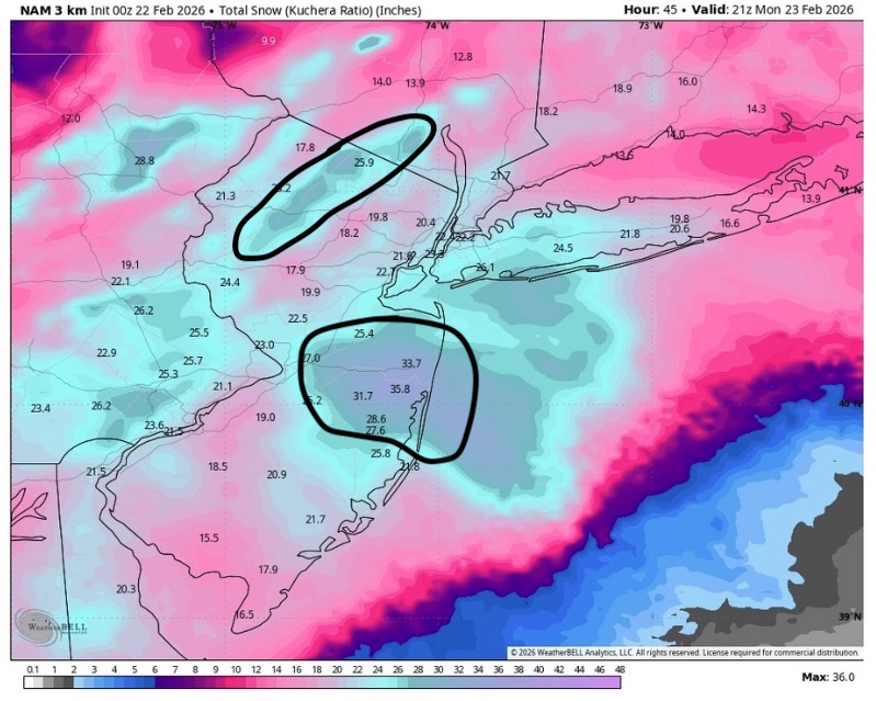
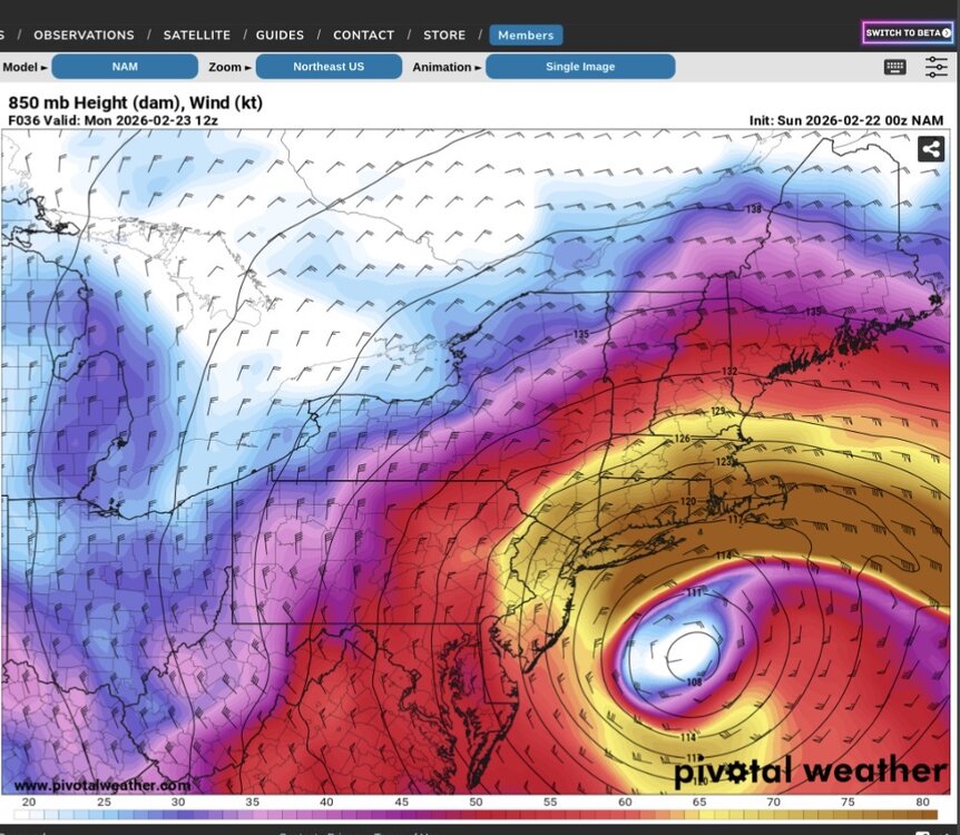
This might be part of the answer. Check out this 850 mb jet.
-
1
-
 1
1
-
-
2 minutes ago, coastalplainsnowman said:
Not to tempt fate, but I'll believe the wind part of this when I see (edit: feel) it. Big wind numbers seem to very often be way overdone, or at least very isolated. Can't tell you how many times I've been out in a storm in which it was snowing hard enough for sure, but was practically calm when high winds were forecast.
I personally experienced winds of this force in February 1983 on the north shore of Suffolk Cty. and had good equipment to measure it. It has happened before and can happen again.
-
1
-
 1
1
-
-
5 minutes ago, Mail Man said:
Yeah I kinda figured it wouldn't
3K NAM has 9 hours of wind gusts to at least 55 MPH at Farmingdale.
-
 1
1
-

May 2026
in New York City Metro
Posted
I experienced a very impressive storm in Brooklyn on the Belt Pkwy while driving earlier. Besides strong winds, lightning , and torrential rains I went through a small intense hail core near Ocean Pkwy. This was big hail with stones up to one inch in diameter. I was in stop and go traffic at the time so I could not take photos. I honestly thought my windshield would be taken out! Flooding from this storm produced flooding on the Belt that blocked two lanes near Cropsey Ave. Time of this was about 6:45 PM