

Tatamy
-
Posts
2,028 -
Joined
-
Last visited
Content Type
Profiles
Blogs
Forums
American Weather
Media Demo
Store
Gallery
Posts posted by Tatamy
-
-
4 minutes ago, uofmiami said:
Suppression got to him. Or may sun angle melted him away.....
Maybe he is slumming around on X looking for content to cut and paste into here to further his narrative.
-
 2
2
-
-
Heavy snow 1/4 mile visibility. 31/30. Storm total now up to 6.5”
-
1
-
-
Heavy Snow 1/8 mile visibility. Storm total 4” so far however it’s been pounding here for the past half hour or so.
-
2
-
-
Moderate snow. 31/30. 2” new OTG.
-
1
-
-
Moderate snow 33/31. Ground is already coated. Silver dollars pouring down. This is going to be some wild morning out here.
-
1
-
-
7 minutes ago, ILoveWinter said:
What in the world is going on with the Euro?! Not saying it's wrong but wow so different.
What are the Mesos indicating?
A lot more than the Euro.
-
5 minutes ago, bluewave said:
Then the question becomes is how much snow will actually accumulate in a place like NYC if the HRRR forecast of 34° to 35° is correct when the changeover back to snow occurs?


Unless you have temps into the mid 20s (which are not expected with this event) streets and sidewalks in Manhattan are likely to be mainly just wet. Neighborhoods in the outer boroughs can get accumulations in this setup however that will be highly dependent on what the specific surface is, if it’s normally shaded during the day, and if it accumulates water on it.
-
34 minutes ago, bluewave said:
I think they made a good point about further storm track shifts with the model runs later today into 0z due to possible changes with convection over the Southeast. So we’ll monitor how the CAMS like the HRRR handle this convection vs the actual radar trends later today.

FWIW the 12z HRRR is running and looks quite similar (there is less snow in the Poconos) to the 6z run. Like you said the 18z run will provide a better look at the evolution of this convection.
-
46 minutes ago, EastonSN+ said:
Wow. That's a massive shift
FWIW the 12z Icon has 5-8” across the area from an event in the Friday night to Saturday period. The GFS has a much weaker event at that time and the other models don’t have this. Something to track during the upcoming week.
-
 1
1
-
-
3 minutes ago, MJO812 said:
.thumb.png.dd2e3cbb31325e37de59c491a386d260.png)
.thumb.png.65452db24d15964400f6e66ebdb3db7b.png)
.thumb.png.3886a8396f771330b9dc292dc6eb5e86.png)
The gradient on this run between the GWB and the Kew Gardens Interchange is something on the order of 6”.
-
2
-
-
21 minutes ago, MJO812 said:
Majority of eps members are off the SNJ coast now.
Another shift south on eps
Did you see the GEPS/CMCE?
-
1 hour ago, LibertyBell said:
Some still think it will pass off the DelMarVa.
You guys have to start criticizing the weather channel, they are spreading false info.
1) They have said for days this is a noreaster
2) They have said for days this is passing south and east of the benchmark "ensuring mostly snow for the coast" (their words....)
3) They have said for days now that this is a "monster" I-95 snowstorm.
I went at them on social media telling them that they make a good case for why people from the south have no clue what an I-95 snowstorm or noreaster even is and why people in Atlanta have no business making weather forecasts for the northeast. So while we can blame "weenies" the real people to blame, once again, is the media, for spreading false information.
Why do you follow the Weather Channel?
-
 1
1
-
-
2 minutes ago, donsutherland1 said:
More snow fell out at Queens and on parts of Long Island than Central Park in the 1969 storm. The storm total precipitation was quite a bit higher at JFK (2.49") than at Central Park (1.82"). JFK sometimes receives more snow depending on the storm's track, dynamics, etc.
There was also banding with it which is common with those types of events.
-
1
-
-
1 minute ago, donsutherland1 said:
I think the focus on a light event is warranted until there is more support for something bigger. The GFS is too aggressive. Apparently, a social media account compared the upcoming event to the February 1969 Lindsay Storm (15.3” in NYC and 20.2” at JFK). But that account didn’t tell a key part of the story: the temperature for that storm fell from 34 into the middle 20s. Most of the precipitation fell with readings that were below freezing. That’s not the case this time around. Were there a similar air mass, then we’d be looking at a significant snowfall. One other omission, the 1969 storm was much wetter than what is likely this time: NYC: 1.82” and JFK: 2.49”.
I believe the Synoptics with that event were quite different than those expected with this one. The ‘69 storm was a Miller B. The total snow amount where I was on the north shore of LI was in the neighborhood of 20-24”. I have a picture of 5-6 foot drifts in our backyard.
-
2
-
-
14 minutes ago, NEG NAO said:
got any graphics to support this ? plus 06Z = outdated data
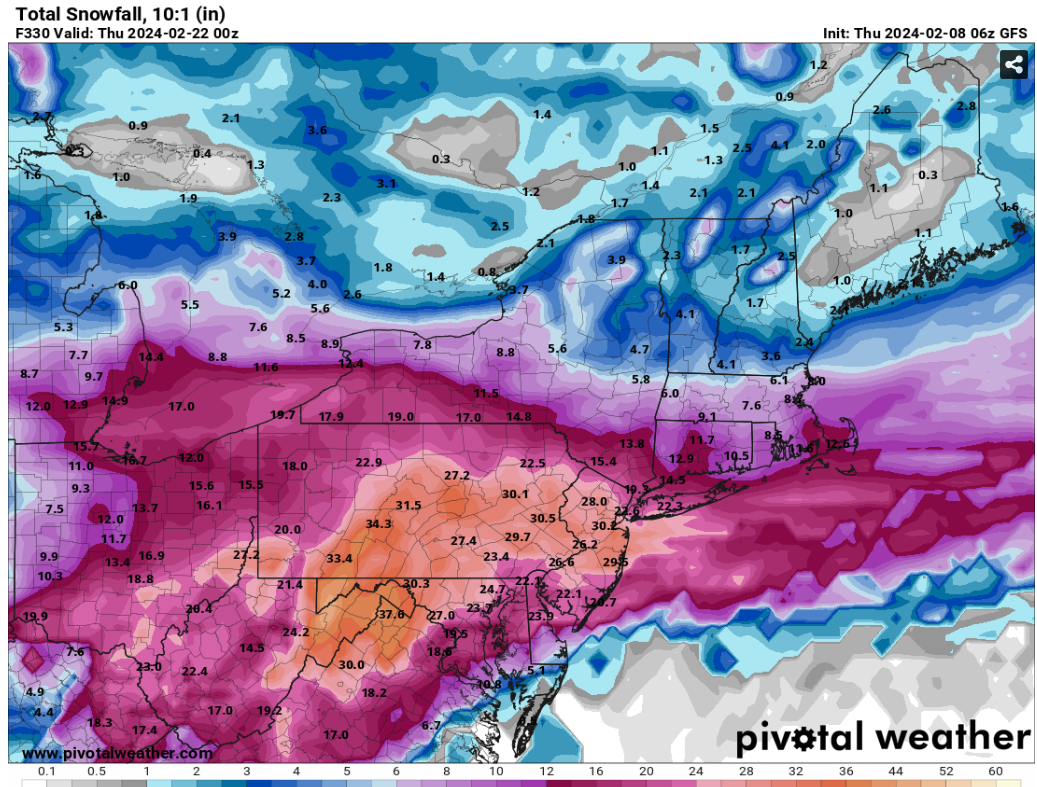
Look on Pivotal.
-
06z GEFS/EPS solutions are very close this morning.
-
16 minutes ago, JKEisMan said:
This would end the snow hole talk.

It really is a weenie run. Four snow storms in a 10 day period starting on or about Monday. This is 2010 redux for the mid-Atlantic.
-
3
-
-
18z GFS has the storm for next week further south again. It’s just one additional solution to the many that are out there for this event. FWIW there were quite a few members on the GEFS 12z run with this further south solution as well.
-
1 minute ago, Allsnow said:
Agreed. If we don’t get a decent storm Out of this setup it’s time to find a new hobby
Good luck with that. I have been sucked into this for over 50 years. It’s not like you can just walk away from it… lol
-
2
-
1
-
-
Bullish run on the 18z GEFS for the period starting after next weekend.
-
1
-
-
1 hour ago, SnoSki14 said:
Snowman really hates that it could snow. Everything I've ever seen from him has been anti-winter.
Now he thinks they'll be suppression. So far this Nino has produced one of the wettest Dec-Jan periods for us and he thinks they'll be suppression.
Delusional thinking
The chart shown here initiated by Tomer Burg would in fact lead to a higher risk of suppression or OTS solutions. FYI Tomer Burg is a well regarded met who knows of what he speaks.
-
3
-
-
1 hour ago, LibertyBell said:
I saw a total of 0.5 inch at Mt Pocono, I guess that's the most we can expect from this.
It’s quite sad that all you can get is 0.5” at 2000’ above MSL.
-
 1
1
-
-
6 minutes ago, LibertyBell said:
Yep, I can do without the plain cloudy days and the plain rainy days, if we just had light snow every other day and a light coating on everything, it would be a lot more cheerful around here.
Very light snow here. Have been getting very light snow and flurries since the overnight hours. Most of it has not been sticking. 34/31
-
 1
1
-
-
9 hours ago, NorthShoreWx said:
The forecast 24 hours before the blizzard of '78 was for a foot or more. It was an LFM success
That was a success however the 1/19/78 event that brought 12-18” across the area was a huge bust to the upside. Forecasts up to the night before were mainly calling for a change to rain after 2-4/3-6”. The first hints that I received that this would be bigger was at 10:00 PM the previous night when WCBS 880 was speaking of trucker reports of a wall of snow on the Jersey Tpke at Hightstown with dangerous conditions south of there. I woke up to 14” inches the next morning before it began to mix with sleet.
-
2
-


.png.377e0e9062e7b84937399de5db67bcae.png)
.png.0b552486cbbf32801a7fb084f310c1e4.png)
.png.b065e5508d343cea61443a9120db5b8f.png)
2/13 Significant/Major Winter Storm Discussion & Observations
in New York City Metro
Posted
All done here - 9.1”