

Tatamy
-
Posts
2,329 -
Joined
-
Last visited
Content Type
Profiles
Blogs
Forums
American Weather
Media Demo
Store
Gallery
Posts posted by Tatamy
-
-
10 minutes ago, Bxstormwatcher360 said:
Well its snowing in parts of coastal mass due to ocean effect and echos breaking out to our south east and west. Im not the most astute meteorologist but from the eyes it def looks west.
We don’t live in Massachusetts. (Unless you’re visiting from the New England board.). Just because there are echoes on radar doesn’t mean it’s snow. You are correct about the precip from the coastal being west however the precip field from that feature will move out to the east this afternoon. If anything accumulates that would most likely be this evening and tonight.
-
52 minutes ago, Bxstormwatcher360 said:
Another tick west for both the nam and gfs 6z suites. Nyc east gets into the main precip shield for a bit now,followed by the ivt. Also of note is the precip running up the delmarva coast currently.

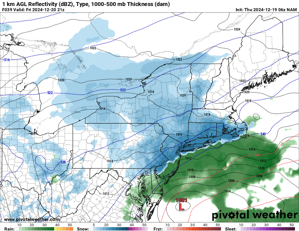
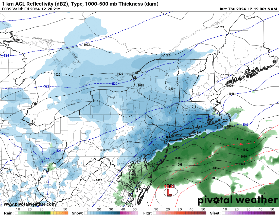
The precip coming up from off the Delmarva coast and right along would be in the form of rain. There are no current reports of precip reaching the ground there. Temps there are in the mid 40s. Temps along the NJ coast and LI are in the mid 30s and that would support mainly rain during the daytime hours with snow possibly mixing in during any heavier bursts on LI. In any case no snow accumulations are expected during the daytime hours except for higher elevations well north and west. This is the theme of what the NWS is going with for the area.
The best chance for snow accumulations for most of us is dependent on additional energy coming in tonight with the trough. We still have the possibility of the formation of the IVT as well for tonight.
-
 2
2
-
-
FWIW whatever snow that falls during the day tomorrow before 4pm will be melting on contact unless you have at least 500-700’ in elevation or are in a place that gets good rates.
-
51 minutes ago, forkyfork said:
pretty much all of them showed an fgen band intersecting a wide dgz
I remember that the HRRR had it but was not sure of the others. Thanks.
-
15 minutes ago, forkyfork said:
the meso models showed the fgen band very well
Which ones?
-
26 minutes ago, Stormlover74 said:
I need to clear out my phone

Looks like it missed the I78 deathband.
-
15 minutes ago, the_other_guy said:
it seems like Mount Holly is worried about mixing near the coast at onset.
But then the models show possible heavy banding along the coast, which would negate that.
Thoughts?
The concern from Mt. Holly about mixing primarily relates to their southern NJ, SE PA, and Delaware zones. For the remainder of their CWA the snowfall amounts will be related to the evolution of the IVT.
As shown on numerous model runs it looks like the primary impacts from the IVT look to be from NYC on west. As for the coastal depending on your model of choice most of its impacts will be east of the city and perhaps well east at that. FWIW some of the models that show the coastal closer to the coast also have rain for a time in the coastal areas. Many moving parts here.
-
1
-
-
This is this morning's AFD from Mt. Holly for the Friday through Saturday night period:
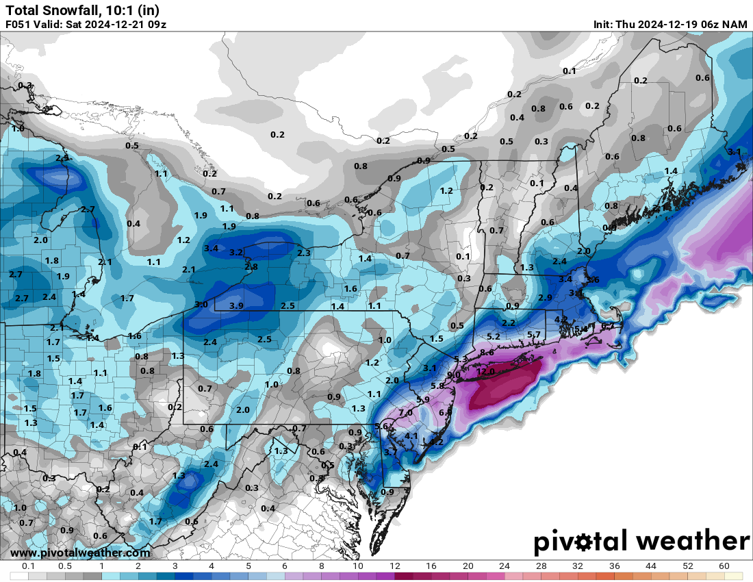
.SHORT TERM /FRIDAY THROUGH SATURDAY NIGHT/...
A deepening upper trough will be approaching the area to close the
week, which will be accompanied with several shortwaves embedded in
the flow. At the surface, low pressure originating over the High
Plains will traverse across the southern Great Lakes region and
approach our region by Friday afternoon. Forecast guidance has
trended a little deeper with the primary shortwave, so as the low
approaches, some precipitation is expected to develop and overspread
the area through the day Friday. At the same time, a secondary low
will be developing a couple hundred miles off the Mid-Atlantic coast
and deepen rapidly as it lifts northeast; enhanced by speed max
rounding base of the upper trough.

With the low offshore remaining in `close enough` proximity to the
area, it is likely that there will be some areas of mainly light
rain and snow across the area on Friday into Friday night as the
initial low transitions its energy to the offshore low. In addition,
some forecast guidance indicates the development of an inverted /
Norlun trough set-up on the northwest side of the offshore low. This
would enhance precipitation across portions of the area, however, it
is still uncertain where or if this feature is to even develop at
this time. For now, the best chance of observing accumulating snow
will be across the Lehigh Valley, northern New Jersey and in the
Poconos where temperatures will be cooler through the duration of
the event. Current forecast snow totals in these areas are for
between 1-2", locally up to 3". Light accumulations of a dusting up
to 1" are possible across the remainder of New Jersey, Pennsylvania
and northern Delaware as rain transitions to snow on Friday night as
temperatures cool below/near freezing. It should be noted though
that these type of inverted trough setups are notoriously difficult
to forecast as they can sometimes have localized heavier
precipitation amounts. If this occurs, some areas could "over
perform" and see snowfall amounts as high as 4 or 5 inches. Best
chances for this would be central into NW NJ, NE PA.

Precipitation will taper off from west to east by early Saturday
morning as the low exits toward Nova Scotia. The remainder of the
day Saturday will be blustery and cold with highs ranging from the
20s to low 30s north with mid to high 30s for highs near and
south/east of the I-95 corridor. Temperatures are expected to the
fall into the teens Saturday night an Arctic airmass begins to take
hold across the region.
-
2
-
-
3 minutes ago, binbisso said:
6z nam. It's the only model showing this but is it on to something.

It was mainly alone on the 0z run however now with the 06z run it is getting some support from the 3k NAM. It’s kind of a long shot but let’s see what the rest of the models do as we go through the day.
-
1
-
-
8 minutes ago, MJO812 said:
No talk about the Nam ? Very close. Eastern LI and SNE Snowstorm.
You do realize that the NAM is literally an ocean apart from all the other guidance. Good luck with the remaining runs from the 0z suite.
-
11 minutes ago, bluewave said:
This was probably the first time we saw such a narrow snowband track exactly due east from Illinois.

Thank you for finding and posting this. Very unique system in terms of how it evolved. The gradient on that was something straight out of a lake effect band.
-
1
-
-
1 minute ago, SnoSki14 said:
There's an inverted trough signal for Friday.
It’s been there for a few days.
-
29 minutes ago, wdrag said:
Also on lack of threads. I try to focus on the more important ones. Obviously snow brightens most of our lives. Trying to reduce MEH takes on events. So for many this coming event (or non depending where you live) may be a MEH. Tracking in one thread coming soon.
I'd love to add Christmas event snowfall too but will reserve for potential separate thread after we get through daybreak Sat with whatever.
Wise move on your part. I don’t think people on this board want to go down the same path as what is going on in the New England forum with the potential system for the end of the week.
-
2 hours ago, Pellice said:
Regarding that February storm last year, had a report on one of the bird alerts that the very northern tip of Sandy Hook, NJ, had a foot of snow while the south end (5 miles south) had much less.
We had the same type of gradient out here with that event. There was some type of convergence zone with this system. The band of heavy snow with this was only about 15-25 miles wide. It was visible on radar out in Ohio the day before. Interesting synoptic setup with that one.
-
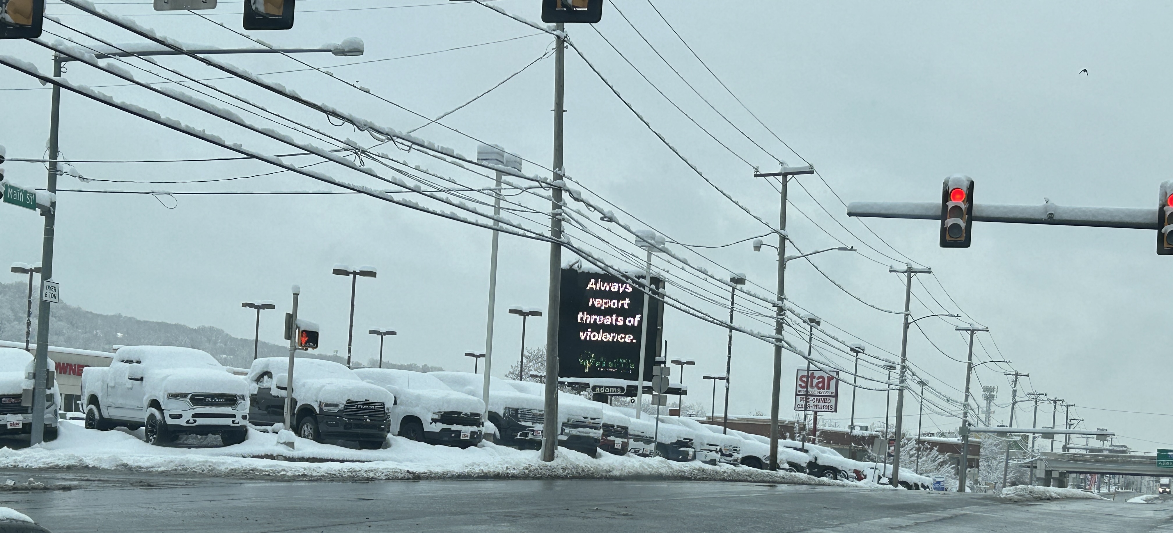
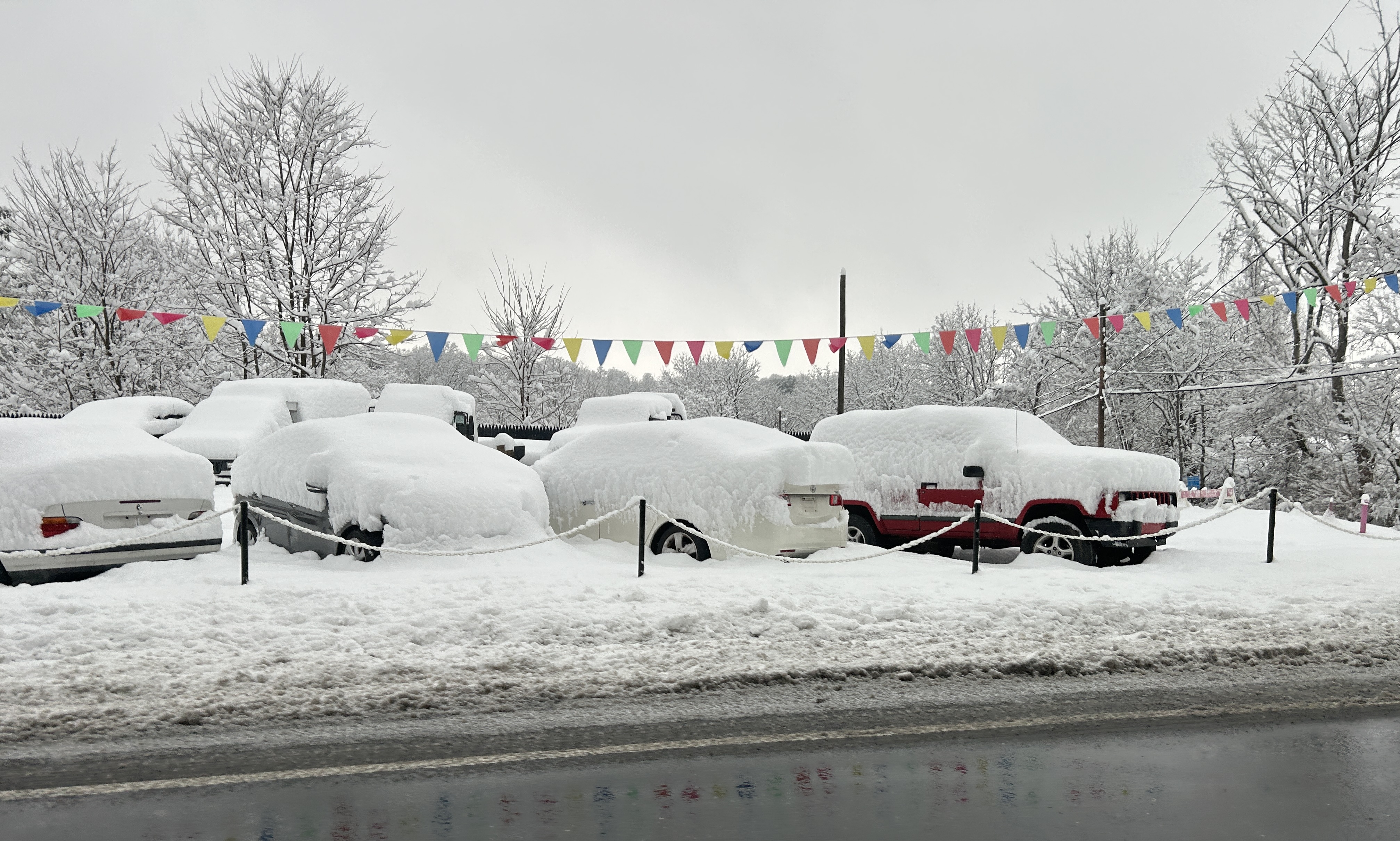
Just now, Tatamy said:
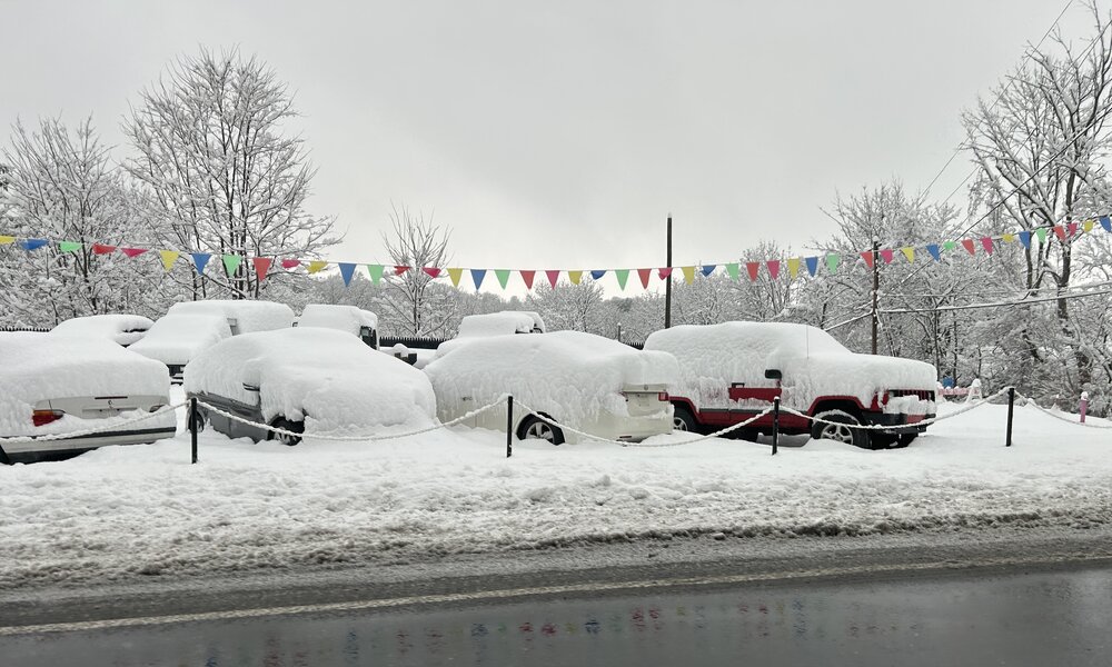
The 2/16 event was also known as the I-78 death band. I took these pictures the morning after. The one with the highway interchange in it was at a car dealership on the north side of Hellertown, PA. About 5-6” fell there. The other one was at a car dealership on the south side. 10” fell there. Crazy stuff

-
2
-
-
32 minutes ago, bluewave said:
That band in CNJ was the exception rather than the rule across the area. All the sites across the area are similar to NYC in having one of their lowest snowfall starts to a decade. It was a bright spot for locals in that area. Almost like a version of what happened in a very narrow band on Long Island in December 1988.

The 2/16 event was also known as the I-78 death band. I took these pictures the morning after. The one with the highway interchange in it was at a car dealership on the north side of Hellertown, PA. About 5-6” fell there. The other one was at a car dealership on the south side. 10” fell there. Crazy stuff
-
2
-
-
4 minutes ago, MJO812 said:

Icon is an outlier. Go with a blend of the other models knowing that this is an IVT and will probably leave a lot of people disappointed.
-
18 minutes ago, MJO812 said:
All the models have shifted west for the weekend storm but will it be enough?
What you are seeing are the globals trying to position an IVT from several days out. I would be very cautious with this setup.
-
6 minutes ago, Wxoutlooksblog said:
While I believe the science of global warming and climate change I do not believe the above data is very good evidence of it. So far in the 2020s Central Park is ahead of the 1980s and tied with the 1970s. With 5 more winters ahead of us this decade this is IMO not evidence that our average number of 30+ seasonal snowfall amounts per decade is going down. We had two in second place back to back 2000s and 2010s.
WX/PT
In the first 8 decades on the list there are 37 winter seasons with seasonal totals of 30” or more. In the last 8 decades there are 22. And yes the remaining winter seasons of this decade could add another 6 to that total if everything goes just right. It’s true that there other ways to analyze this. However even if we are lucky enough to get 2 or 3 30” winters in the remaining years of this decade there is still a big difference in the numbers.
-
Listed below is a summary of winters by decade that had 30” or more of snow in Central Park. This is from the NWS website. The numbers speak for themselves. Seasonal snow totals are declining with global warming. A lot of people were spoiled by the number of large storms that occurred in the first two decades of this century. Unfortunately these storms and the resulting higher snow totals were not representative of the longer term seasonal norms for this region. It’s a bitter pill for snow lovers to swallow however this is climatology.
1870s - 5
1880s - 7
1890s - 5
1900s - 4
1910s - 5
1920s - 2
1930s - 4
1940s - 5
1950s - 2
1960s - 4
1970s - 1
1980s - 0
1990s - 2
2000s - 6
2010s - 6
2020s - 1
-
2
-
 1
1
-
 1
1
-
-
Have 0.3” of mainly sleet and ice OTG.
-
1
-
-
46 minutes ago, snywx said:
29F w/ lgt snow falling
coating on all surfaces
Mix of Snow/sleet. 33F
-
34 minutes ago, sussexcountyobs said:
Light snow falling . Whitening car and driveway. 31.9°
Have the same happening here.
-
Just now, MJO812 said:
Good trends so far today with the storm for next weekend. Vort is digging more compared to 0z.
Huge changes
Huge changes run to run. They are really struggling with this pattern.
-
1
-


OBS for NYC CP first measurable minor snowfall? 11A Fri 12/20-11A 12/21, embedded with surrounding area periodic minor accumulative snow
in New York City Metro
Posted
Currently heavily overcast where I am. 31/25. There are a few lonely snow flakes around as well.