

Tatamy
-
Posts
2,031 -
Joined
-
Last visited
Content Type
Profiles
Blogs
Forums
American Weather
Media Demo
Store
Gallery
Posts posted by Tatamy
-
-
8 minutes ago, MJO812 said:
Cmc


Euro had this back at 12z. It was further inland with its track but a big hit.
-
 2
2
-
-
1 hour ago, MJO812 said:
I will watch it especially the trailing vort .
Interesting evolution with this event as shown on the 12z NAM. Front end thump Saturday afternoon into the evening for areas to the north and west and then most areas that had snow go to light rain/ice and sleet. Most areas including the coast go back to snow later Sunday as the trailing vort max comes in.
-
1
-
-
1 minute ago, Brian5671 said:
Most don't tune into TV newscasts anymore-like you said it's all social media clickbait and hype..
That is so true.
-
1 hour ago, MJO812 said:
Boston gets crushed on every model now. We can't win at all.
It's amazing
This is exactly what it was like in the 70s and 80s coming of age on LI. Most every winter was like this with a few exceptions. I did not experience a storm with greater than 8” of snow that I could remember until I was 16. I remember one time there was an event where it rained on the island and snowed on the hills in CT not far from the sound. The following afternoon I went to a nearby beach and could see it across the sound in the late afternoon sun. It is what it is and it represents the climatology of the area.
-
1
-
-
17 minutes ago, RU848789 said:
Y'all are falling down on the job, lol. I've been away (playing disc golf) for several hours and I come back to a great GFS run that came out an hour ago and nobody posted this map? It's not the JMA or the Chilean model, c'mon.
More seriously as many of us have been saying, let's see what we get at 18Z/0Z tonight after all the players are being well sampled by the RAOB network. Maybe the GFS will be an outlier, maybe not, but I'd rather have it in the snowier than before camp.

Snow amounts on here are a lot greater than those shown on its ensemble mean.
-
1
-
-
1 hour ago, Snowguy66 said:
Question. Has DT posted any updates lately?
.He’s liking the Euro/EPS.
-
16 minutes ago, RU848789 said:
The Pivotal page is definitely well done, but they acknowledge that in marginal temp situations it's simply very difficult to translate the "snow that falls" to the "snow that accumulates." Also, as I've discussed many times over the years, Kuchera is very simplistic (it simply takes the warmest temp in the air column and has a simple algorithm reducing ratios based on that temp only) and doesn't account for snow crystal shape impact on accumulated depth nor snowfall intensity, which can easily overcome melting in some situations.
IMO, as someone with significant expertise in crystallization, heat transfer and phase change dynamics, the biggest "miss" in that page is not accounting for intensity, nor the fact that once there is some accumulation on a warmer-than-32F surface, the "new" surface is now snow/slush, which, by definition is then 32F, meaning subsequent accumulation of snowfall will no longer be significantly impacted by melting on that surface, plus air temps a few degrees above 32F will have a very small melting effect, since heat transfer via air to the snow is far less than from a solid (the ground) or liquid (e.g., wet ground/puddles), due to the huge density difference, primarily (air is far less dense, which is why the heat transfer coefficient is about 20X less from air than water, for example - that's why one can kep one's hand in a -10F freezer for minutes, but can't keep one's hand in a 32F cooler filled with ice/water for more than a few seconds).
This is why we can see snow accumulate quite well at high to high intensity in April during the day with ground and air temps well above 32F - and we're not going to have ground or air temps that far above 32F in this case, plus we're not going to have any solar insolation issues for most of the storm, at night and even during the day, as the sun angle is still quite low. I'm not saying we're going to see 10-15:1 snow to liquid ratios (which is what we'd likely get with good dendritic growth we're likely to see where the snow crystals are being formed, if that snow didn't encounter above 32F air in the column nor above 32F ground), but I am saying getting to 8-10: ratios shouldn't be that much of a stretch, as long as we have decent intensity.
This is a really great piece and provides a much needed scientific perspective to the ongoing conversation here regarding snow to liquid ratios.
-
4
-
 2
2
-
-
12z RGEM is in a totally different world as compared to the 12K NAM at the end of their runs in terms of precip type, extent, and temperatures.
-
1 minute ago, donsutherland1 said:
This page explains it and has some links to more detailed discussions:
Great article- Thank you!
-
1
-
-
7 minutes ago, bluewave said:
Yeah, two issues in play. The actual ratios and the raw model cold biases. But even the MOS numbers have been too cold at times this winter. That’s why I wouldn’t even think about specific accumulations until under 72 hrs or even 24 hrs in a marginal situation like this.
I asked Snowman but you might know the answer to this. What variables are used to calculate the total snowfall positive depth change?
-
36 minutes ago, snowman19 said:
The people using 10:1 ratio maps in a setup like this and thinking that’s actually going to verify are going to be shocked at the actual result. They are going to be grossly inaccurate. This is why the total positive snowfall maps are night and day different
Do you know what variables are used to calculate this?
-
51 minutes ago, bluewave said:
I don’t trust those 10:1 charts in marginal temperatures.
There is no law in the annals of physics that states that snow has to fall at a ratio of 10:1. There seems to be a lot of people who believe that it does however that is not the case.
-
1 hour ago, kdennis78 said:
What's well inland? I honestly would welcome snow or even ice over rain. My yard can't handle more rain.
I-84
-
1
-
-
06z Gfs has a flatter weaker system. Of more interest is the system for the 10th. Twenty four hours ago this was being portrayed as a big soaking rainstorm. The models are now showing a system that provides a significant front end dump of snow to some well inland areas before a change to rain. This evolution has been quite interesting to watch. Coastal areas are all rain with this one.
-
3 minutes ago, MJO812 said:
We are seeing the confluence pushing more and more south tonight . Maybe we can squeeze out a few inches here.
I don’t even want to think about what must be going on in the NE forum tonight.
-
1
-
-
3 minutes ago, MJO812 said:
Models look great tonight
Gfs and cmc
.thumb.png.1082428bb1186bddfbc45ac3d849ab9d.png)

The other take away here is how the increased confluence is creating a stronger downslope flow in the LHV and the CT River which greatly reduces accumulations up there.
-
2
-
-
11 minutes ago, Rjay said:
Did I seriously read a post about initialization errors today?

You really did… lol
-
 3
3
-
-
2 minutes ago, Allsnow said:
These models and maps are always changing
I think the models have been reasonably consistent so far with this event.
-
19z BOM goes with 7-9” across eastern/NE PA, western/NW NJ, SE NY, and interior CT.
-
1
-
-
3 minutes ago, mikeysed said:
Do you have the Kuchera map? As I don't think 10:1 will be accurate for i95 and east
Kuchie actually looked pretty good.
-
3 minutes ago, cleetussnow said:
Anyone look at EPS? I imagine not good since no one has mentioned it. This winter.
It was not bad if you are inland. The axis of heaviest snow would be from northern NJ across SE NY to interior CT. The ensemble mean in this area calls for 6-7”
-
4
-
-
2 minutes ago, Stormlover74 said:
Its pretty par for the course. There are other boards where its nothing but hugging the coldest and snowiest model and anything else is considered negative. I think most on here have a decent understanding of how these things work. It's also highly possible that NYC gets nothing for this event or the follow-up and has to wait until late month which many people said from the beginning. So its nice to have something to track despite all the model hugging and wishcasting. Now onto the euro in a few where we'll all be throwing in the towel or back on board depending on what it shows.
Good post. Regarding the follow up apparently no one here has looked at what the CMC OP does with it… lol
-
23 minutes ago, Newman said:
Big time changes on the GEFS
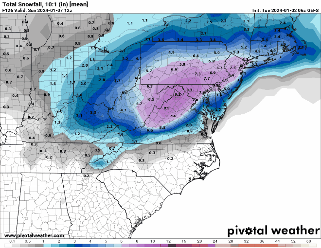
The run that you show for today at 12z does not show the full duration of the event so this is misleading. The axis of heaviest snows has shifted to the northwest and with this run is over NE PA, NW NJ, and SE NY. Those areas see between 5 - 6” with the event with lesser amounts to the south and east.
-
43 minutes ago, psv88 said:
Thinking this is a mainly white rain event for the island. Maybe a sloppy inch or so on the north shore and some mangles flakes on the south shore.
we will get our chances later in the winter.
You should hold those thoughts until the S/W is more fully analyzed by the North American RAOB network and the short range models can parse this.
-
1
-
.png.9a77786ddd193663ddefdcca447cfb37.png)

Two Mdt to high impact events NYC subforum; wknd Jan 6-7 Incl OBS, and mid week Jan 9-10 (incl OBS). Total water equiv by 00z/11 general 2", possibly 6" includes snow-ice mainly interior. RVR flood potential increases Jan 10 and beyond. Damaging wind.
in New York City Metro
Posted
On a different note for those of you that are interested in subscribing to Pivotal (the source of most of the model runs on these boards) they are having a flash sale and are offering the Hobbyist subscription at $75.99 for the year. Use code HAPPY2024 at checkout. The normal rate is $99.99 per year.