

Tatamy
-
Posts
2,037 -
Joined
-
Last visited
Content Type
Profiles
Blogs
Forums
American Weather
Media Demo
Store
Gallery
Posts posted by Tatamy
-
-
8 minutes ago, bluewave said:
NYC and LGA along with the immediate shoreline like Long Beach and Breezy Point will probably have to wait until after Thanksgiving for the first freeze.
Lows
Jones Beach…37
Breezy point…37
Montauk…37
EWR…32
NYC…35
LGA….37
JFK…31
FRG…30
ISP….27
HPN…28
HVN…27
TEB….28
BDR….30
East Hampton…20
MJG….19
Low of 38 at my remote station at Cherry Grove on Fire Island. The atmosphere never did decouple there.
-
23 here. Our coldest so far this season.
-
 1
1
-
-
4 minutes ago, psv88 said:
Northern Florida in the 20s. NYC at 35
Frost/Freeze warnings this morning from the NYC area all the way down to SE Texas. Looks like a very large section of the east coast and gulf coast all ended their growing season on the same night.
-
6
-
-
27 was the low here. Thick frost everywhere.
-
82 for a high today.
-
1 hour ago, TriPol said:
The GFS is on some premium quality stuff this morning:
This would be a hurricane moving up from the NW Caribbean that hits Florida and then moves up the east coast and draws in cold air resulting in lights out for New England. Weenie candy anyways.
-
 1
1
-
-
44 minutes ago, TriPol said:
Well, howdy there...
This event has been appearing on some operational runs and on some ensemble members for days now. The Euro had it at 0z as well. I will describe it for what it is which is a talking point for now. In any case there is the potential for an early season elevation event for areas well inland as we go through next week.
-
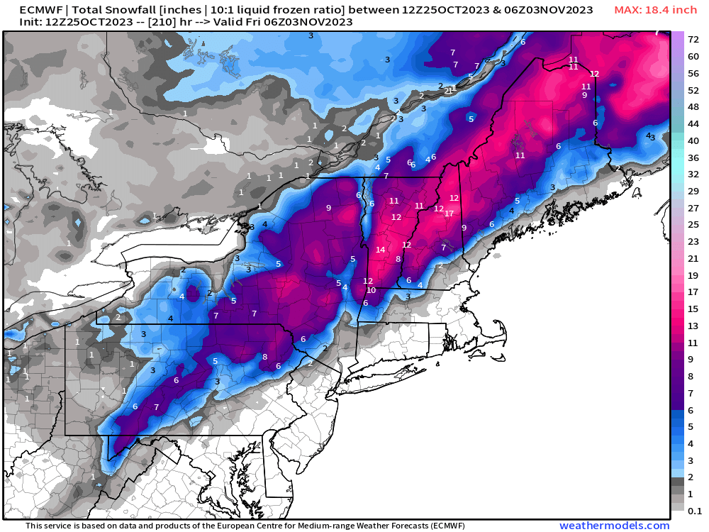
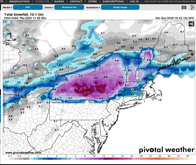
2 hours ago, qg_omega said:
Great Halloween for the kids

Depends on your location. 12z GFS for 10/31 - 11/01
-
2
-
-
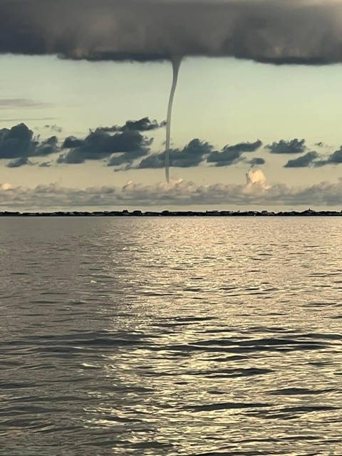
The photo below was posted on FB earlier. It was taken on Great South Bay to the north of Fire Island Pines after 5:00 PM. This is looking towards Davis Park.
-
8
-
 2
2
-
-
48 here. Has not even reached 50 today. 0.54” so far with the event.
-
1 hour ago, Brian5671 said:
not too much though or it's 2/5/10 all over again...
There’s a lot of people on this board that would not want a repeat of that one.

-
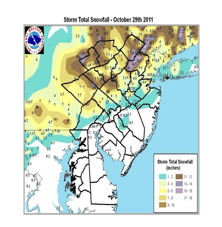
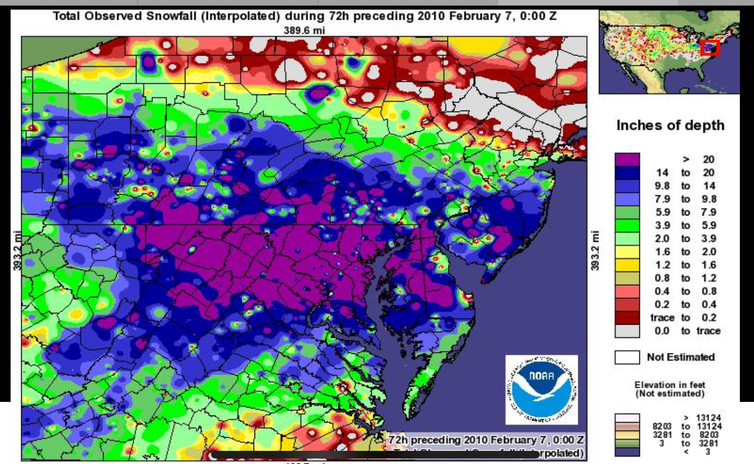
Storm totals for the 10/2011 event
-
5
-
1
-
-
8 minutes ago, psv88 said:
My rain gauge back up and running after a few years out of commission.
It’s reading 0.04, radar estimate shows 0.09. Not sure what’s more accurate
If you want an excellent rain gauge get one these. This is one of the best ones out there and you can currently get a good deal on it from Amazon.

-
1
-
-
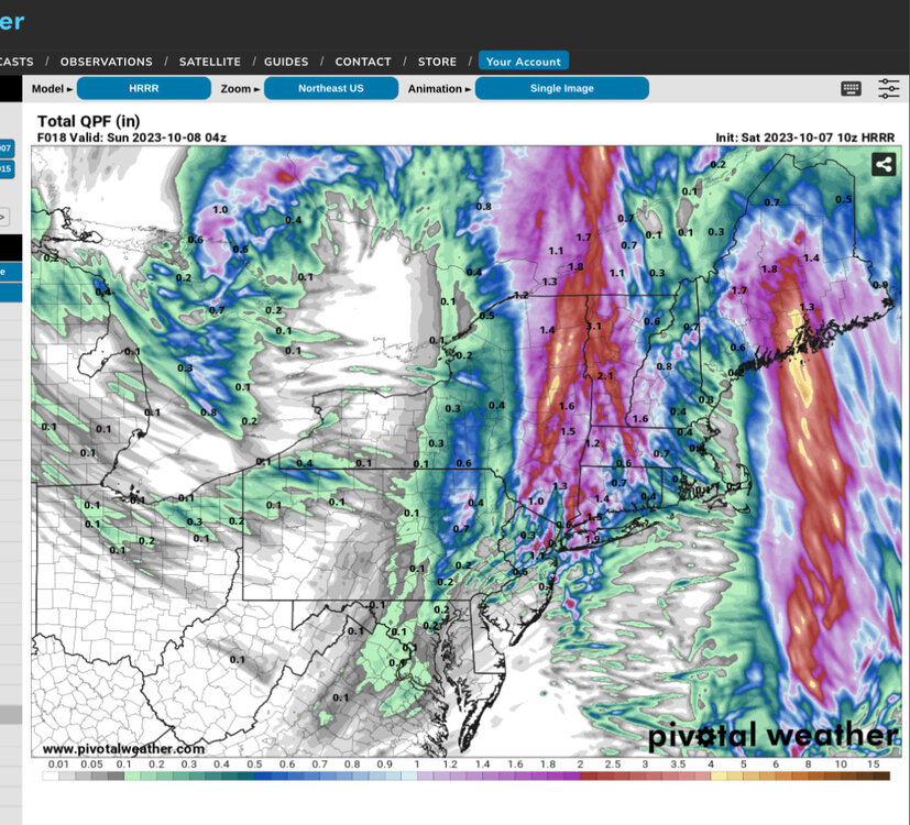
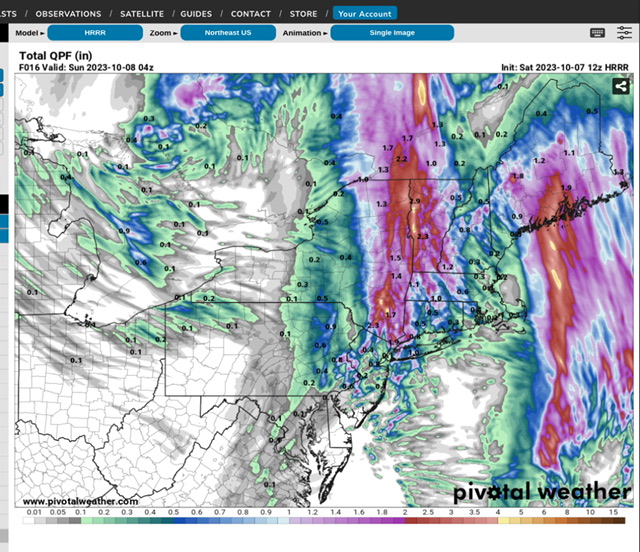
2 hours ago, qg_omega said:
HRRR backed way off
HRRR is jumping all over the place with amounts in my area ranging from virtually nothing in one run to over one inch two runs later. Who to believe?
-
1 minute ago, WestBabylonWeather said:
Babylon in on the action now. Let’s see how this plays out
2.1 for the day
.My station at Cherry Grove on FI is still waiting. 1.25” so far with the event.
-
1
-
-
Just now, jm1220 said:
You can see on the radar how this setup works-the smaller cells firing up over the ocean and heading NW, then exploding into the firehose when they reach the inverted trough.
You can also see the flow from the SW into the trough from central NJ. Very interesting event that is unfolding here.
-
20 minutes ago, nycwinter said:
is this the first time that a inverted trough actually produced for the city? they never seem to do...
No there are other instances where IVT’s have produced in the city.
-
2 minutes ago, EWRNJ said:
Maybe not. Strong band moving west into NJ. FFW just extended until 3 pm for Union City, NJ
.The flooding in the city is being caused by an inverted trough (IVT). In this setup the winds are coming from different (opposing) directions on either side of the trough in the lower levels of the atmosphere. The result is moisture present in the atmosphere is being forced to rise where the trough is setup resulting in the downpours that are being experienced. These features are known for being prolific rain producers and as long as this one remains where it is the problems will continue.
-
4
-
2
-
-
8 minutes ago, cannoliman42 said:
Almost all subways from Manhattan to Queens have been suspended due to flooding/loss of power in the tunnels. The only one still running is the 7, which hopefully hangs on. Otherwise, a lot of people may be forced to take the LIRR or end up stranded in the City.
Let’s hope the LIRR does not get flooded out.
-
1
-
-
16 minutes ago, Pequest said:
Wow sun coming out now between the clouds out here in Warren County!
Same over here.
-
1
-
-
35 minutes ago, weatherbuff85 said:
storm is done for northeast pa
This was never going to be a big hit for eastern or northeastern PA. FWIW I have two weather stations. One here in eastern PA and the other on Fire Island (Both are Davis stations). There is a 12” difference in the YTD rainfall totals between the two. When we were getting deluged back in the summer those areas nearer to the coast were dry a lot of the time. Now that difference is getting worked off - unfortunately a lot of it in one day.
-
3
-
-
0.37” here in eastern PA. 0.88” at my station on Fire Island.
-
1
-
-
6 hours ago, gravitylover said:
My recollection of Gloria is it wasn't all that bad. Nothingburger comes to mind. I do remember walking outside and being in the eye with bright sunshine and a rotating wall of white and grey framing a deep blue circle in the sky. That was pretty cool.
I guess you were not old enough to remember it with much detail. This was the worst storm to hit LI in the last quarter of the previous century.
-
2 minutes ago, Amped said:
Why track Lee when you can track the 336hr gfs storm.

12z is doomsday for NYC… lol
-
1
-


November 2023
in New York City Metro
Posted
We were out in CO on vacation in September. We spent a day near Aspen and were up on a hill and saw my first cat paws of the season on the windshield during a rain shower. Even in the daytime it struggled to reach 60. Being near 10K feet above sea level will get you that. I know they have already had accumulating snow in the Denver area.