

Tatamy
-
Posts
2,044 -
Joined
-
Last visited
Content Type
Profiles
Blogs
Forums
American Weather
Media Demo
Store
Gallery
Posts posted by Tatamy
-
-
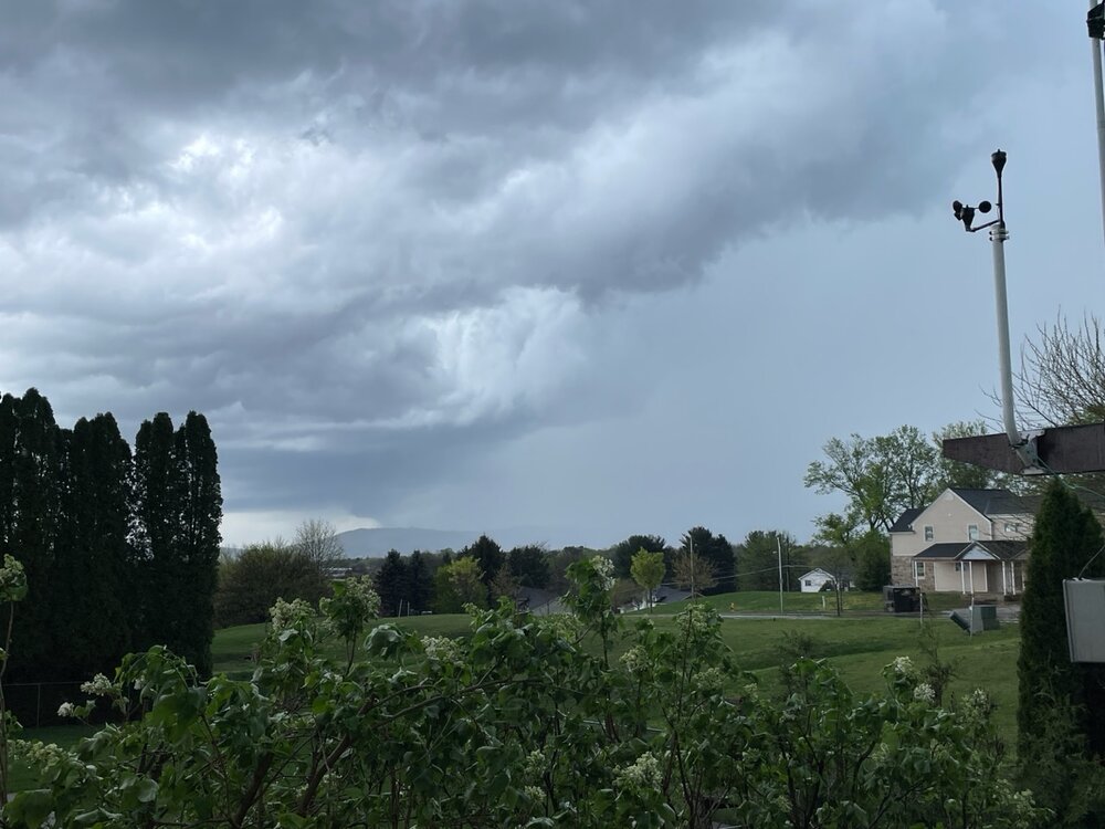
Seems unusual to have a sea breeze this far inland however that is exactly what has occurred here today. I reached a high of 78 at 4 PM and have now dropped back to 58.
-
My total from yesterday was 1.45”
-
Between cells currently. 1.20” on the day so far.
-
Just to keep things interesting we just received some pea size hail along with close in CTG lightning.

-
 2
2
-
-
This is the cell just to my SW. There is radar indicated hail with this.
-
5
-
-
Now under a FFW for the training cells in my area. Apparently there are radar estimates of 2 - 2.5” having already fallen with another 1 - 2” possible. The axis of this is just a couple of miles to my west.
-
1
-
-
Atmosphere has popped directly over me and it’s pouring. Models since yesterday have been insistent on at least a half inch of rain here with some calling for over an inch. I am already at a half inch with this downpour. Mt. Holly has issued a SSW for my area. Just some rumbles currently.
-
1
-
-
86 here. Hottest day so far this year.
-
1
-
-
Severe Thunderstorm Warning for the cell arriving now.
-
1
-
-
15 hours ago, bluewave said:
Severe storms can overperform on Saturday even to the coast with steep mid-level lapse rates, strong shear, an helicity. Morning warm front with possible multiple rounds convection in afternoon into evening. The key may be getting enough spacing between all the storms. But there can be squall segments and supercells. The models are all over the place on convection timing and placement. The Euro has morning, midday and evening convection.


We are starting off the day out here with a loud booming thunderstorm. This definitely looks to be an interesting severe day. These cells are rolling east quickly into NJ too.

-
1 hour ago, Tatamy said:
I am currently seeing snow falling along I80 (heavy in places) for many miles to the north and west of State College. If you are up there in elevation across NE PA, NW NJ, and in places especially from Orange Cty north and west I think you have a real shot to wake up to some snow on the ground (HRRR is on board). This Arctic front certainly does mean business.
Heavy snow showers/ squalls currently moving across northern and northeastern PA and into the western Catskills.
-
1 hour ago, Bxstormwatcher360 said:
That cold front means business. I wouldnt be shocked to see rain to snow even here in the city,not to mention the winds associated with the frontal passage itself. Could be a wild couple of hours later on tonight. The last gasp of old man winter!!
I am currently seeing snow falling along I80 (heavy in places) for many miles to the north and west of State College. If you are up there in elevation across NE PA, NW NJ, and in places especially from Orange Cty north and west I think you have a real shot to wake up to some snow on the ground (HRRR is on board). This Arctic front certainly does mean business.
-
3
-
-
Rates have picked up out here too. Visibility at 1 mile with a temp of 32.0
-
19 minutes ago, LibertyBell said:
sunset is in 5 hours though
How much snow did you get at your place in the Poconos?
-
41 minutes ago, sussexcountyobs said:
Just measured 7 here. Temp is 27.7 with steady moderate snow falling.
And you were worried about getting snow yesterday up there! Models hit your area fairly well and they seem to be verifying.
-
1
-
-
Light flurries here. 33.5
-
1
-
-
1 minute ago, sussexcountyobs said:
The light rain that has been falling, is changing to wet snow. 34.4°
Wet snow is also falling in the higher elevations of the Poconos above about 1100’.
-
Mt. Holly cancels the WSW for Warren and Morris Counties and issues a WWA for these counties. A new snow map has been issued.
-
 1
1
-
-
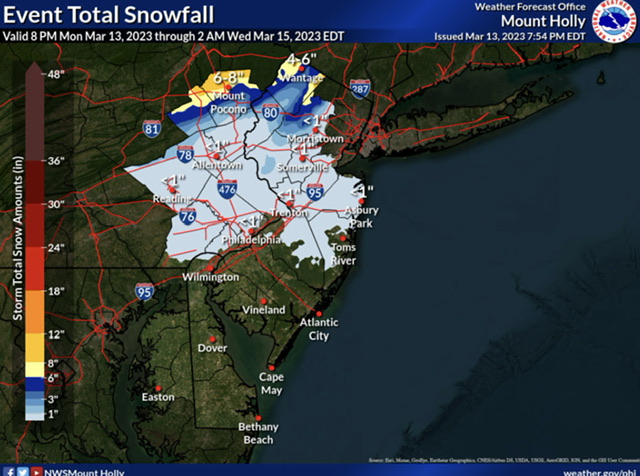
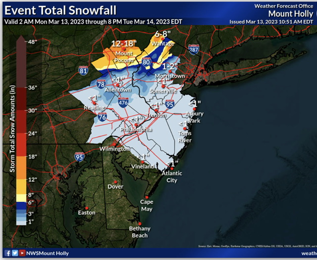
Latest Mt. Holly snowmap
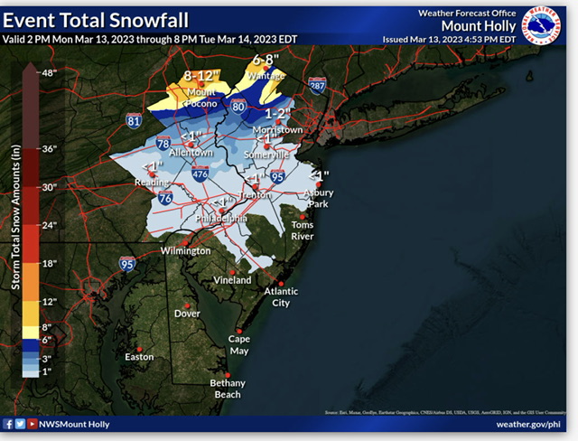
-
1
-
-
1 minute ago, MJO812 said:
I hope this storm busts high
There’s a lot of reasons to sell it.
-
8 minutes ago, sussexcountyobs said:
Cool. Thankyou Tat. I wonder if Upton's map matches up with that?
Looks like it does.
-
1
-
-
1 minute ago, Stormlover74 said:
Morris needs to be split up. No way most of the county gets near warning criteria
Morris County? How about Warren County? That’s another one. I think this reflects the difficulty inherent in the technology they use in terms of issuing a warning for part of the County. The idea is for the user to look at location specific forecasts which do account for elevation and how that impacts local snow amounts.
-
1
-
-
22 minutes ago, sussexcountyobs said:
Area Forecast Discussion National Weather Service Mount Holly NJ 945 AM EDT Mon Mar 13 2023 .SYNOPSIS... A complex coastal storm will affect the area today through Tuesday night. High pressure then builds into the region Wednesday through Thursday. A cold front approaches on Friday and passes through on Saturday. High pressure returns on Sunday. && .NEAR TERM /UNTIL 7 PM THIS EVENING/... Surface low pressure off the North carolina coast this morning will slowly deepen while moving N/NE today. Rains associated with it have already overspread most of the CWA with the exception being Berks county and wrn Chester county PA. Adjustments to pops and wx have been performed for the mid- morning update. For the southern Poconos, temperatures will be colder with (near freezing this morning). These temperatures will be cold enough for snow at the onset. The highest elevations will likely receive 1-4 inches of snow by midday Monday. By this point, temps will start creeping up into the mid 30s as easterly flow brings in warmer air, and with the coverage of advisory level snow expected to be confined to the highest elevations, continued with the decision to not issue an advisory for this early portion of the event. && .SHORT TERM /7 PM THIS EVENING THROUGH WEDNESDAY NIGHT/... A strong area of low pressure will be east of the Virginia/North Carolina border this evening, as a secondary low lifts along the New Jersey shore just offshore, and this low will lift towards western Long Island by daybreak Tuesday. Most of the region will be in the warm sector for most of the rain for most of the night, though temperatures in the southern Poconos, especially in the higher elevations of Monroe county, will be cold enough to support all snow. With low pressure beginning to take on a more northeasterly track as it lifts towards western Long Island, cold air advection will develop as winds shift to the north. The rain/snow line will then spread south through the Lehigh Valley and most of northern New Jersey, mainly north of the I-78 corridor, and accumulating snow will develop during this time. Snow then continues to spread south Tuesday morning. The main question is how far south snow will get. Think there may be some light accumulating snow as far south as the Philadelphia metro area and into southern New Jersey, but really not expecting much more than an inch or so from around I-195 south. The primary low over the western Atlantic will lift towards eastern New England Tuesday morning, and then this low will merge with the aforementioned secondary low. Precip continues to wrap around this system into the southern Poconos and northern New Jersey into Tuesday afternoon before ending Tuesday evening. Strong shortwave energy will pass through the region Tuesday night, keeping light accumulating snow, mainly over the northern zones. In terms of snow totals, generally expecting 1 to 2 feet of snow across Carbon, Monroe, and Sussex (NJ) counties, though the highest snow amounts will be in the higher elevations, and most areas will pick up about 1 foot or so from tonight through Tuesday. From 6 to 10 inches of snow is possible down to the I-78 corridor, mainly from early Tuesday morning through Tuesday. Will go ahead and convert the Winter Storm Watch to a Winter Storm Warning for Carbon, Monroe, and Sussex (NJ) counties, and will also go ahead and add Warren and Morris counties, as the heavier bands of accumulating snow look to spread a bit farther south. The heaviest snow in Morris county will be in the western half of the county, and snow amounts may be minimal across the eastern half of Morris county. For now, do not think Winter Weather Advisories are needed elsewhere. A tight pressure gradient develops over the area between the low and high pressure building in from the west on Tuesday and Tuesday night. However, latest runs of the models seem to have the low a touch farther east, so the gradient is not quite as strong as it looked in prior runs. As a result, expecting northwest winds 20 to 30 mph with 35 to 45 mph gusts, which are just below Wind Advisory criteria. Although a Wind Advisory may end up being needed for the coastal strips, will hold off one one with this package.
This is their latest snow map. I am not so sure about snow amounts of 6-10” as far south as I-78 (I am assuming that refers to places west of I287). That might be a stretch. In any case the map does do a good job of matching elevated areas to increased snow amounts.
-
1
-
-
3 minutes ago, NJwx85 said:
GFS has a crazy snow gradient over Rockland and Westchester.
Could be 8"+ in places like Tompkins Cove and Yorktown Heights while Nyack and White Plains get under an inch.
Is there a big difference in elevation there?


April 2023
in New York City Metro
Posted
50 with light rain here.