

Tatamy
-
Posts
2,044 -
Joined
-
Last visited
Content Type
Profiles
Blogs
Forums
American Weather
Media Demo
Store
Gallery
Posts posted by Tatamy
-
-
45 minutes ago, LibertyBell said:
Being after our greatest winter made it less annoying than most.
The prediction was for 8-16 inches of snow lol
We got 1-2 and closer to 1.
More snow south of us on the Jersey Shore (6-8) and a lot more snow north and northeast of us.
Sort of the same thing happened in April 1996 but we got 4-5 inches here and the dryslot was over the city, while south of us on the Jersey Coast got 6-8 inches and in Suffolk County it was 12-16 inches with blizzard conditions all the way to the Hamptons.
9” with that one out in Sayville. I was living there at the time.
-
 1
1
-
-
39 minutes ago, romba said:
This:
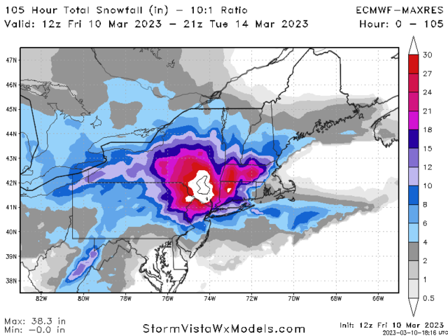
Vs same run on pivotal

Let's not get out hopes too high off of one crazy weenie map, I think the pivotal is more realistic here
You will only be seeing 10:1 ratios if you are in a location where banding sets up. Otherwise these just are entertaining digital artwork.
-
3
-
-
With this mild antecedent air mass in place anyone expecting 10:1 ratios with this event is going to be disappointed.
-
2
-
-
4 minutes ago, LibertyBell said:
2 pm right on schedule.
Had 6" in the Poconos from the last event
As I noted in my other post there is light snow starting to fall in many places across northeastern PA. It is not sticking anywhere that I looked.
-
1
-
-
Light snow breaking out currently across northeastern Pennsylvania especially in the higher elevations.
-
1
-
-
Light snow falling in the Harrisburg area with this system coming in from the west.
-
4 hours ago, Intensewind002 said:
6-8 in Babylon and then like <0.5” in Patchogue would be the craziest cutoff I’ve ever seen for the island
With BL temps in the mid 30s on Saturday in the daytime hours a lot of this is not going to stick.
-
2
-
-
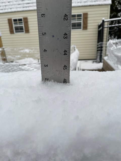
2 hours ago, Tatamy said:
Snow is pretty much done here. 1.5” new.

Final total here is 2”
-
3
-
-
39 minutes ago, MJO812 said:
Euro likes storm 2
I just woke up, looked outside and then saw that. I thought to myself WTF this is beyond insane. It’s looks like something the GFS would dream up.
-
1
-
 2
2
-
-
Snow is pretty much done here. 1.5” new.
-
7
-
-
Heavy snow is now falling across much of northern and northeastern Pennsylvania as currently shown on radar. Near whiteout conditions in some places along I80. 37/31 with cloudy skies here.
-
1
-
-
Mixed light rain and sleet. 43/26.
-
Precip along I80 between the Williamsport and Hazleton areas is currently reaching the ground as some light rain. That area will change over a little later as the more intense precip/ rates starts to move out of NW PA.
-
1
-
-
2 minutes ago, winterwx21 said:
18z NAM has the solid band of snow going right across the middle of the area, like the HRRR and EURO. Nice to have an event trending our way at the last minute for a change this winter.
This event is going to be focused on a relatively small part of the forum mostly between I80 and Route 22. Will be interesting to see who JPs in that area. Mt. Holly has just issued WWA’s for Warren and Hunterdon Cty’s in NJ in addition to adjacent areas in NE PA. I have not had to use my snow blower for two years. I am hoping that I won’t have to use it tonight so we’ll see how that works out.
-
1
-
-
Back to tonight’s event. In spite of what is being shown on precip type radar right now much of what is falling in south central PA is wet snow or a mix of rain and wet snow. It is not sticking in most places out there currently. However as the sun angle piece diminishes over the next hour or two that will change as this precip moves towards the north and east. This evening is looking to be more interesting at least for some of us if this holds.
-
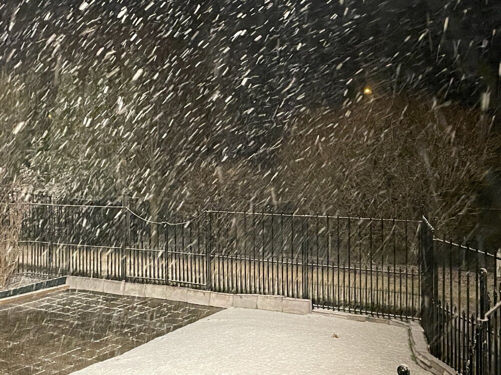
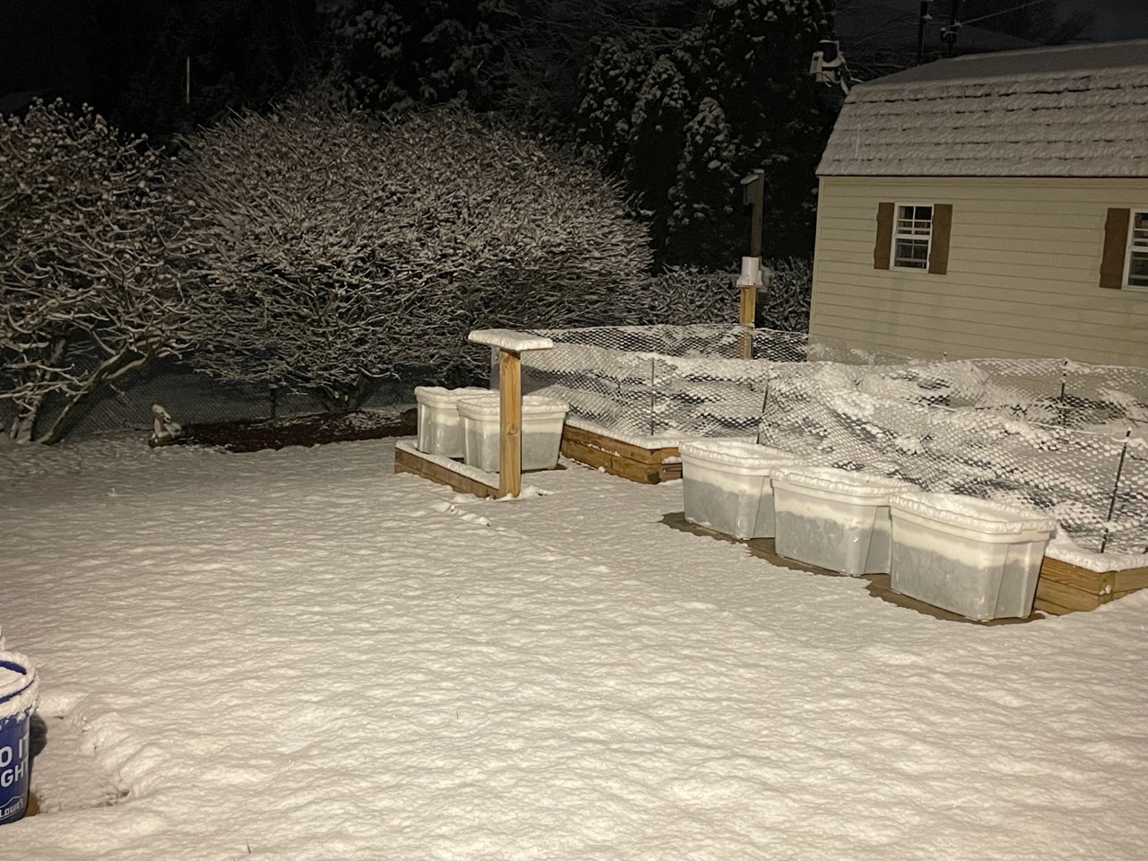
Current conditions out here.
-
6
-
-
Moderate to heavy snow now coming down in the Allentown area on west along I78 towards Hamburg. Visibilities have really dropped in that area.
-
1
-
-
Steady light snow. 33/30
-
Steady snow and sleet falling here.
-
1
-
-
3 minutes ago, SnowGoose69 said:
yeah this is a strange case where the air mass got better as you got east closer to the departing high
Very true!
-
1 minute ago, sussexcountyobs said:
It's actually all snow here. Plow just game by salting. Not sticking on roads yet. They had plow down? Probably just wearing them out to justify next year's budget.
You’re going to be in a good spot with this event. By the time the precip reaches your area the atmosphere will be cold enough so most of it can fall as snow.
-
1 minute ago, Jaguars said:
the real game looks to be the precip betweetn Harrisburg and Allentown, that’s the show
.That precip is actually falling as a mix of rain and sleet in that area.
-
As the first wave of precip comes through the area pay attention to the dew points. Mine went from 18 to 31 as that band of light precip came through.
-
1
-
-
I have a mix of light rain and snow falling here. 40/23.
-
1
-

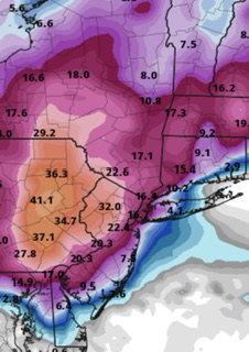
March 11th storm threat
in New York City Metro
Posted
Snow levels out in the Poconos near Stroudsburg look to be about 800 - 900 feet currently. Not sure what they are at in NW NJ.