

Tatamy
-
Posts
2,028 -
Joined
-
Last visited
Content Type
Profiles
Blogs
Forums
American Weather
Media Demo
Store
Gallery
Posts posted by Tatamy
-
-
FWIW the 0z HRRR is a big hit across the metro area and northern and central NJ.
-
 5
5
-
 1
1
-
 1
1
-
-
Snow is done here. Final total 2.5”. 27/22
-
1
-
-
Moderate snow here currently. The echoes in the Allentown area are the real deal. We had light snow earlier which had diminished to a light mix. Precip picked up again in the last 30 minutes and with it the flip back to snow. 25/23
-
2
-
-
Light snow here. 2” new OTG. Schools closed and roads are dicey.
-
1
-
-
Steady light snow. Visibility 2 miles. 23/20
-
1
-
-
Light snow has started here. Visibility 2 miles. 25/16
-
1 minute ago, Franklin0529 said:
I'm in coastal Monmouth county an it's not even snowing yet here
It’s still south of you.
-
1
-
-
I am watching this snow coming north through central NJ and it really comes in like a wall. You go from flurries to decent rates quite quickly.
-
1
-
-
The leading edge of the light snow runs from just south of Reading over to the Trenton area. This lines up well with the heavier echos seen on radar.
-
3
-
-
Steady light snow falling throughout the Philly area and the suburbs. There is steady light snow falling as far north as the Trenton area.
-
6 minutes ago, SnowGoose69 said:
Its more the main mechanism to get precip here won't start to move north for a bit...I'd say 830-9pm it begins but this front running area was always expected to mostly miss..you should begin to start seeing the area down in N VA and the Delmarva accelerate due north in the next 1-2 hours
Strongly agree. Best snows that I have seen are in the western Philly suburbs. They have a coating on the ground near West Chester.
-
5 minutes ago, SnowGoose69 said:
This little virga area has helped saturate the atmosphere down to 5-6,000 over the metro...its still 8-9,000 further north in the LHV. You need ceilings down to around 3500-4000 to begin snowing so this has helped that cause somewhat. Snow should reach the ground by NYC by 8-9pm at worst
I have been seeing flurries for a couple of hours already and this relates directly to what you stated above.
-
2 minutes ago, MJO812 said:
Why is everyone downplaying this event ?
Great ??? The models that I have been following have been gradually increasing totals through the day. They actually seem to be in fairly good agreement. The increase in expected totals from Mt. Holly speaks for itself.
-
1
-
-
I have a few light flurries here as well.
-
Light snow and flurries in the Philadelphia area now as well.
-
Light snow and flurries getting underway currently to the SW of Harrisburg. You have to go down to the MD in order to find a coating to a half inch on the ground.
-
1
-
-
4 minutes ago, SnowGoose69 said:
BTW I really doubt LGA/NYC west ever go to rain, so -FZRA/PL unfortunately is likely, hopefully it will be light but if the coastal continues to tick a bit more west and higher QPF makes its way in we could get a tenth of ZR...ideally we'd want to keep it sleet. JFK east I think goes to rain but 030-050 winds on almost every high res model for LGA/NYC won't flip them to rain
My rule of thumb from when I lived on LI (north shore) was for nothing higher than 065. If you stayed on the lower side of that you were usually okay if the mid levels were good.
-
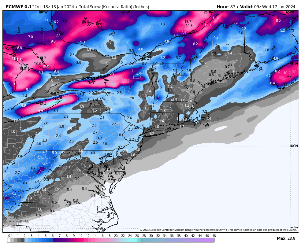
2 minutes ago, HeadInTheClouds said:
GFS caved to the mesos with low closer to coast and more qpf inland.
.thumb.png.02229f90fe80db6cfab484959c9cb66c.png)
The RGEM and even the ICON have had virtual ownership of this event for days. The performance of the GFS as relates to the event has been subpar at best.
-
2
-
-
6 minutes ago, MJO812 said:
Agree
Looking better for inland areas compared to earlier in the week.
Dew points out here have been in the single digits since the middle of yesterday evening. This very cold and very dry airmass will be an important player in precip start times, qpf, and ratios especially north and west of the city.
-
2
-
-
06z EPS mean is 2”+ across the area with highest amounts east.
-
2
-
-
Real cold air is still north and west of a line that runs from roughly Harrisburg to Scranton to Albany. Temperatures in western PA are down into the low and mid teens. 38/15 here currently.
-
6 minutes ago, Stormlover74 said:
Parts of MD got an inch
It’s really hit or miss with today’s activity.
-
There are snow squall warnings in my area of eastern PA. From what I can see most of what is on radar is actually snow flurries or showers. In any case the area to be cautious in the short term would be I78 in western NJ. Just a few flurries here currently.
-
1 minute ago, Allsnow said:

The Euro caves
.png.aa801b2a0c88b8b4b7502f4b5f2eb8d0.png)
Snow Friday 1/19/24: is it a period of light snow (less than 2"), or is there a chance of a 5" swath in part of the NYC subforum? Event OBS.
in New York City Metro
Posted
Now we need the RGEM to do better.