

Tatamy
-
Posts
2,032 -
Joined
-
Last visited
Content Type
Profiles
Blogs
Forums
American Weather
Media Demo
Store
Gallery
Posts posted by Tatamy
-
-
This product only shows wind gusts of up to 60 MPH. By extropolation and the fact that both the Euro and NAM are forecasting SLP with pressures in the 970's I would argue that off shore wind gusts would have to be in the range of 80 - 100 mph with resulting seas.
-
 1
1
-
-
-
12z Euro 10 m AGL Wind Gusts - If you are on LI make sure your generators are ready to go...


-
1
-
 1
1
-
-
44 minutes ago, Stormlover74 said:
Squall incoming
.gif.6d45071800f78d8ac1c0c3c003233be0.gif)
We have had a few light showers as well this afternoon. It’s a chilly one now as the temperature has dropped to 52. 26 hours ago it was 80.
-
Just had a wind gust to 33 mph with the approach of this squall line.
-
1
-
-
1 hour ago, SnoSki14 said:
Me thinks the severe threat will be greater than expected. Getting ample sunshine with temps near 80
We are getting underway with a squall line now forming up west of Allentown and moving to the east and northeast.
-
1
-
-
1 hour ago, uncle W said:
tree rings and sediments...
I bought a house out in Sayville in 1995. Once we moved in we decided to have 10+ large trees removed. These were large Oaks. I counted the rings on all of them and the larger ones all dated to 1939. The island was sparsely populated then however there is no doubt that the destruction to trees in the area had to have been catastrophic following 9/21/1938. Tree rings can tell you a lot.
-
1
-
-
1 hour ago, LibertyBell said:
I mean not that because I hate tornadoes, but something like Belle which didn't really cause much damage at all.
Belle caused hundreds of thousands of power outages across LI.
-
1
-
-
5 hours ago, LibertyBell said:
I really wish we could get a Cat 1 every year around this time, is that asking too much? I want to see a Cat 1 make landfall in our area (ACY to MTP) once every year, that's not too destructive and they are fun to track.
When will the waters warm enough to make that happen?
You need to be careful what you wish for. If a Cat 1 does make landfall somewhere in the area you outlined it will be destructive for at least some of us. I had the opportunity to see the tornado damage done in Bucks Cty, PA this year by Ida and trust me you would not want to see that in your neighborhood.
-
1
-
-
Big temperature gradient in my area with low 60s in Sussex and parts of Warren Cty’s in NJ to low 80s just south and west of Allentown.
-
1
-
-
Reached a high of 79 today at 4:20pm. The back door arrived at 4:30pm and it promptly took us down 10 degrees.
-
I am in the thick of it out here in eastern PA. 0.72” so far and still coming down. Have not seen any sun at all today.
-
Tornado warning in the Reading, PA area right now.
-
This is a view of the action as the line forms up west of Allentown.
-
2 minutes ago, LibertyBell said:
report of nearly 8 inches near and just to the east of Allentown.....do you have any numbers in that range?
I am at 5.34” so far for the event.
-
2
-
-
9 minutes ago, LibertyBell said:
Historically speaking and regarding the severe weather aspect of this would you rank this higher than November 1989 and Labor Day 1998? Those are the only two I could compare the level of tornadic activity we are seeing compared to this event.
Not in the same league- at least in the Philly area.
-
1
-
-
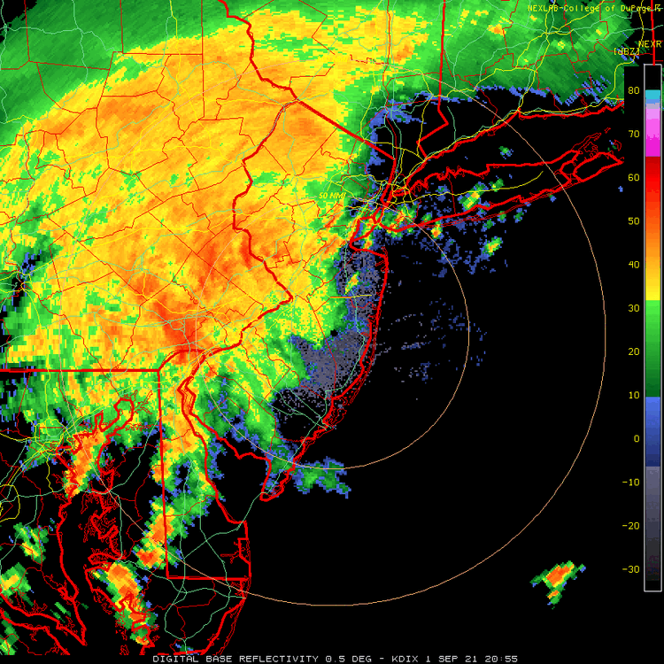
Strong couplet on radar near S. Brunswick NJ. Any live coverage on the New York stations of this event?
-
The most vigorous mesocyclone is in the Princeton area now. It is expected to be in the general area of Edison NJ by about 8pm.
-
4.5” inches of rain so far with this event.
-
3
-
-
Kudos to the folks at Mt. Holly for all their hard work tonight keeping us warned of all of these threats.
-
9
-
-
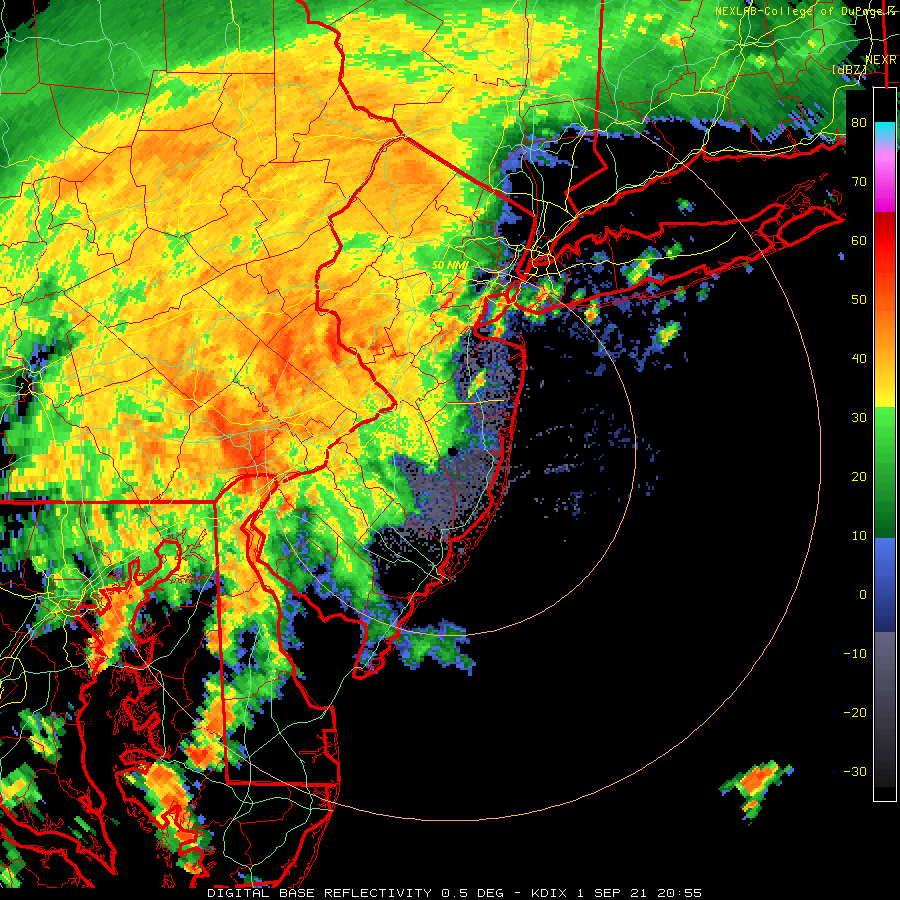
4 minutes ago, Gravity Wave said:
Yeah, the New Hope - Lambertville tornado that fortunately didn't touch down until it had mostly passed the town.
I hope their luck still holds as another tornado is now reported near Washington Crossing.
-
14 minutes ago, forkyfork said:
writing is on the wall
How about the spin on this radar! You folks in central NJ are going to be next in line for the tornado activity.
-
Multiple tornado warnings currently up in the Mt Holly WFO including Philadelphia.
-
 1
1
-
-
4 hours ago, donsutherland1 said:
10-15. Orographic enhancement likely contributes.
The placement of the precip max just south of Allentown corresponds with South Mountain. That is the ridge that I78 weaves in and around in that vicinity.
-
2
-

Two large rain/wind events 10/25-26, 10/28-30 w probable totals by Oct 31 of 2.5-8" in the NYC subforum, damaging wind and SVR potential for one of these storms
in New York City Metro
Posted
I have both. Davis is better. Weatherflow is not as good with rain fall amounts. In heavy rains the ultrasonic wind equipment gets faded out so you don’t get accurate wind measurements. Stick with Vantage Vue or Vantage Pro 2.