

Tatamy
-
Posts
2,032 -
Joined
-
Last visited
Content Type
Profiles
Blogs
Forums
American Weather
Media Demo
Store
Gallery
Posts posted by Tatamy
-
-
12z HWRF at 60 hours is 20mb deeper than the 06z run. It’s also further west.
-
 1
1
-
-
Tornado watch issued for much of eastern Pennsylvania.
-
1
-
-
44 minutes ago, bluewave said:
The main challenge is that the GFS is the furthest west global model. The UKMET, CMC, and Euro are more east. But the UKMET still impacts the Cape. The GFS is usually incorrect when it’s the furthest west on storm tracks. So we would need to see the other models shift further west in future runs for it to be believable. But it’s still too early in the game to pin down the exact track. We are heading into the highest tides of the month with the full moon. So even an offshore track will cause the swells at high tide to fill up the tidal pools on the back beach areas.
Bingo!!
-
2 minutes ago, Brian5671 said:
This is all still a week away folks. Wait a few more days to buy the plywood and sandbags
With a track like this higher tides will begin to cause flooding in susceptible coastal areas Saturday morning.
-
1
-
-
1 minute ago, LibertyBell said:
You dont really believe any of these wild solutions like the HMON to you Chris? The ones that have the storm swinging NW into NJ or NYC or Long Island? There isn't a record block in place like there was for Sandy and those kinds of scenarios are more probably in October, not August. Dont you think the furthest west this could go is Cape Cod?
There are no absolutes as far as track goes with this one. The models are still working it. There is a full moon on Sunday morning so the coastal flood threat is very real.
-
1
-
 1
1
-
-
15 minutes ago, Sn0waddict said:
HWRF looked like it was going out to sea. But then last minute it gets pulled NW.
From the 0z run to the 06z run of the HWRF the center is moved a full 3 degrees west in longitude. That is huge.
-
2
-
-
06z HMON winds at 114 hours

-
2
-
-
06z GFS

-
Next Full moon is Sunday 8/22. As currently projected there will be coastal flooding impacts from Henri. This could be the most significant impact from the storm in our area.
-
Next Full moon is Sunday 8/22. The track and timing of this storm are going to have coastal flooding impacts to the mid Atlantic region and northeast.
-
On 7/29/2021 at 8:16 PM, SRRTA22 said:
Im speechless at whats going on down there
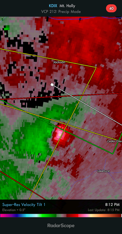
They confirmed today that this was in fact a tornado. It was rated EF0 and the path ran for 3/4 mile in a remote wooded area near the Lakehurst Naval Air Station. They needed an aerial survey in order to get confirmation.
-
1
-
1
-
-
3 hours ago, Pequest said:
Yeah Will...Warren County poster here. Total fizzle here as it crossed the Gap. Just a few drops!
I received 0.01”. They literally ran out of gas a few blocks from me. Lol
-
6 hours ago, turtlehurricane said:
Fred definitely being upgraded to TS at 11 pm, 40 mph SFMR on latest pass
Fred was not upgraded to a TS at 11pm. NHC now expecting it to regain TS status during Friday. Recon says that the mid level center is still 40 miles east of the LLC. This means reintensification will be slow to occur at best.
-
20 minutes ago, turtlehurricane said:
Not even the bullish HWRF runs from previous days showed deep convection going up this quick over the center.
Also, deep convection will drag circulation northwards and eastwards due to shear vector.
I have a very strong feeling we could have a hurricane in Miami. All the ingredients for a big surprise are in place.
Did you read the 5pm discussion from the NHC? The part about 20 kts of shear and a lack of organization? The system is not projected to re-attain Tropical Storm status until Friday night when it passes 100 miles south of Miami. This is not going to hit Miami as a hurricane. There may well be other storms that threaten Miami with hurricane force winds this season but not this one.
-
1
-
-
20 minutes ago, turtlehurricane said:
NHC generously downgraded Fred to a TD, when in-fact it is likely once again a ‘potential tropical cyclone’
NHC also fixing center on northern coast where we all see it.
I posted on the potential for this to happen yesterday. It’s not uncommon for this to happen especially with these weaker systems.
-
3 hours ago, NorthHillsWx said:
Poor Fred, about to take the worst path possible for land/mountain interaction
Next step with this storm is to see if it re-centers itself along the north coast of Hispaniola while crossing the mountains. Time to look for evidence of that would be this evening. If this occurs it will have implications on the track going forward.
-
Next round is on its way in.
-
Currently getting a rain shower with light winds and no lightning. So much for the bow echo anyways. Will watch to see if it pulses up as it moves into Warren Cty.
-
1
-
-
Intense squall line with a healthy looking bow echo now moving into my area from west of Allentown.
-
If this system interacts with Hispaniola as shown on the expected track, let’s watch to see if it recenters along the north coast. This is not unusual with these weaker systems and will have implications on the eventual track as it tracks north of Cuba.
-
2
-
1
-
-
22 minutes ago, justinj said:
A much needed soaking rain for suffolk. Anyone have totals for middle island/miller place area? Recently moved and haven’t setup weather station yet
I checked on the Davis site. Two stations in Miller Place. 1.28” and 1.42” are the totals so far.
-
1
-
-
25 minutes ago, LibertyBell said:
it's always the weekend though lol
But hadn't we already had a very rainy July? why is the rain so needed now after nearly a foot of rain fell in July?
Why weren’t you at your house in the Poconos this weekend?
-
Gorgeous weather out here today with no rain at all. Sunny, 85 with light winds and scattered Cu. We are fortunate to be under an area of subsidence between the coastal system and another one over the upper Midwest.
-
The line is getting ready to cross Blue Mountain and move across the Lehigh Valley. With light rain and temperatures in the 60s here it does not appear that this feature will have too much left by the time it reaches the Delaware River Valley and western NJ.

August 2021
in New York City Metro
Posted
I second that request. Plenty of lightning so far with these storms.