

Tatamy
-
Posts
2,044 -
Joined
-
Last visited
Content Type
Profiles
Blogs
Forums
American Weather
Media Demo
Store
Gallery
Posts posted by Tatamy
-
-
-
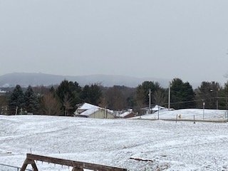
Moderate Snow 31F with this first burst moving across eastern PA.
-
 1
1
-
-
Moderate Freezing rain. 31.6. Trees and shrubs starting to accumulate ice.
-
1
-
-
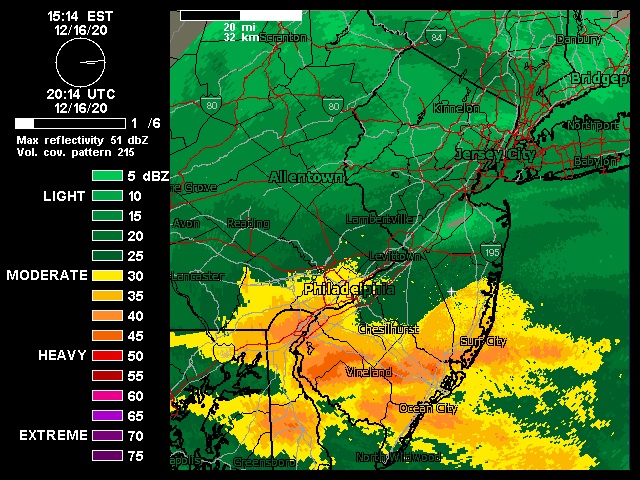
18z GEFS - No support on the ensembles for next Friday that I can see here. With the current pattern in place focusing on an event on the OP at 168 hours is fantasy.

-
1
-
-
32 with Freezing rain
-
24 minutes ago, HVSnowLover said:
Admit it’s trending colder still think its a minor event but interesting rgem/nam both now haven the rain/snow line right near or over the city
We will have to see if subsequent runs are like this. Previous runs of the RGEM have kept the R/S line mostly north of I80. Up to now this model has been steadfast with a warmer solution. Agree that this is a minor event for most.
-
18z RGEM comes in colder. I would go with 5:1 ratios between I78 and I80.

-
32 with light rain here.
-
-
18 minutes ago, HeadInTheClouds said:
It's also further north and west with the low than the GFS, just like Euro and Ukie. I think NYC metro and Long island are going to see a cold rain unfortunately. I may see a few inches but it won't be all snow even by me 20 miles north of 84.
12z UKMET

-
 1
1
-
-
-
Cold front has just passed through. Temperature has dropped to 44F
-
1
-
-
Total rainfall so far this event - 1.20". Highest wind gust - 33 mph.
-
2
-
-
0z NAM output for highest wind gusts


-
1
-
 1
1
-
-
12z Euro maximum projected wind gusts


-
1
-
-
It's been quite an evening here. We now have sleet pellets mixed in and according to Dual Pol Doppler we will be transitioning soon. We have had 8" so far. 19F / DP 18F. Blizzard conditions reported at ABE.
-
7 minutes ago, SACRUS said:
Assume the sleet/mix to near Phil
It is still snowing in southern PA right near the DE line.
blob:https://www.511pa.com/53ece02f-f11f-4747-bc4e-c081fede4295
-
1
-
-
This is the wall of snow approaching from my south.
-
18 minutes ago, jm1220 said:
FWIW the “wall” of heavy snow we need is setting up pretty well down in MD and VA.
I am seeing very light snow begin here. There is steady light snow falling to my west between Allentown and Harrisburg. Visibilities that I am seeing in those areas look to be about 1 - 2 miles along I-78. Along I-81 to the south and west of Harrisburg visibilities drop off steadily. I am seeing 1/4 mile visibilities as you go down towards MD.
-
Watching snow spread rapidly to the east from Harrisburg towards the Allentown/Bethlehem area. I am expecting snow to reach me by 1 PM or so based upon what I am seeing unfold to my west.
-
1
-
-
Watching snow break out rapidly across south central PA. Visibility has dropped significantly in the Harrisburg area.
-
1
-
-
Just checked some Penndot cameras in south central PA. Snow is moving into the Harrisburg area and is coming down steadily along I-81 in south central PA.
https://www.511pa.com/CameraListing.aspx?OpenPage
-
1
-
-
18 minutes ago, tdp146 said:
On the wind side of things, I received my new Weatherflow Tempest last week and hustled to get it up above roofline yesterday. I’m still in a pretty bad spot locally for wind measurements but I got it up at a height of 23.5 feet.
https://tempestwx.com/station/34338

Enjoy. I have had mine for a few months. It's a nice station.
-
1
-
-
9 minutes ago, wdrag said:
Wantage NJ 4sw: Had mostly r- and some ip- for about 90 minutes but all snow (2mi) now. 0.2" total so far...its wet snow out there but didn't clear. we'll see what we have at 1P. 33.1F. pave wet. 942A
Exact same conditions here. Now all steady wet snow - coating on the ground - Visibility 1 mile 33.0F
-
2
-


Sunday-Monday Jan 3-4 potential rapidly intensifying ene moving nor'easter along the mid Atlantic coast with rain to snow mainly I84 to near I95 north through west of NYC
in New York City Metro
Posted
12z NAM has totally missed this initial burst of snow. According to it the Lehigh Valley (I am in Bethlehem Twp.) gets no snow today. It's only 9 AM and a lot of models have already busted on the day. I am at 1" myself and it is still coming down. The 12z HRRR has trended colder for the area near I-78 in eastern PA and NJ.