

Tatamy
-
Posts
2,032 -
Joined
-
Last visited
Content Type
Profiles
Blogs
Forums
American Weather
Media Demo
Store
Gallery
Posts posted by Tatamy
-
-
Severe Thunderstorm warnings out here for the expected winds with this squall line. I am not presently detecting lightning with it.
-
 1
1
-
-
3 minutes ago, Oliviajames said:
Walt Reading is at 65 degrees. Much higher than the 59 you wanted yesterday. Squall line approaching and should be here in the next 30 minutes.
You will see some impressive winds with the squall line in a few minutes as a bow echo passes you.
-
 1
1
-
-
1 hour ago, LibertyBell said:
Walt what kind of wind gusts were reported near ABE?
Wind gust to 63 mph reported at Altoona, PA with the passage of the squall line. Wind gusts of between 20 - 30 mph are occurring ahead of this feature across eastern PA at this time.
-
1
-
-
2 minutes ago, Brian5671 said:
you sure about Nov 24-30 1989? I recall that being during the stretch of brutal cold that Nov into Dec
That was the year of our Thanksgiving snowstorm with 4.7” in Central Park on 11/23/89.
-
1
-
-
My max here has been 37 mph at 9:25 and 10:05.
-
Wind is howling out here in eastern PA with the passage of the cold front. Wind gusts to 33 mph within the past 15 minutes.
-
2 hours ago, SnoSki14 said:
GFS has consistently been showing a Caribbean hurricane that eventually goes up the east coast.
Strong WAR pattern would support such a track.
06z GFS has it east of Cape Hatteras at 348 hours. 12z GFS has it west of Key West at 342 hours. It’s an interesting thought anyways...
-
2 hours ago, wdrag said:
Wantage NJ 0.06 so far since 330A.
0.09” Event total in Bethlehem Twp. PA
-
1
-
-
42 minutes ago, psv88 said:
40.1 this morning. Radiated extremely well here
Same out here. I am a native LIer and can tell you that there was an early season Arctic air mass that impacted the area back around 1974/1975. This event produced high temperatures in the 40s and lows of about 30 on the north shore of LI during mid October at that time. For the time of year it was impressive. In any case I have personally never seen frost anywhere this early in the season until today.
-
1
-
-
35 out here with patchy frost in the area.
-
1
-
-
4 hours ago, SACRUS said:
Lots of clouds

Any one take notice of the shadowing effect on the cloud deck caused by the easterly flow drying out slightly as it crossed LI and NYC extending into eastern PA. This has been seen on visible satellite almost all day. This is not something that I can recall seeing.
-
2
-
-
This line is a fast mover but is not producing anything significant here except for a torrential downpour. Minimal CTC and no significant wind as the 50 DBZ echoes pass directly over me. 0.65” in the rain gauge with this line so the mesoscale models did well with rain amounts with this feature today.
-
This line is putting out a lot of lightning right now as it comes out of the Poconos. It is producing 2-4 strikes per second according to my Tempest.
-
Mt. Holly has issued a SSW for my area for the line heading towards me from Carbon County, PA. Looks like it will be a quick hitter.
-
We are popped right now with an intense cell moving overhead and providing torrential rainfall.
-
Torrential rain is occurring with this feature. It’s winding down here and we have picked up 0.79”.
-
An impressive light show with the squall line as it passes through. Frequent CTC/CTG Is accompanying this feature. No strong winds here.
-
1
-
-
NAM is looking increasingly lonely on the 18z runs in calling for higher rain amounts for tomorrow for the majority of the metro area. The GFS and RDPS would bring heavier amounts to LI and parts of the city however most other model runs have negligible amounts except for central NJ and points south.
-
36 minutes ago, Stormlover74 said:
Decent batch of showers in eastern pa. Let's see if they hold
Heavy rain with thunder out here. This batch means business.
-
Final rainfall total - 7.15"
-
1
-
-
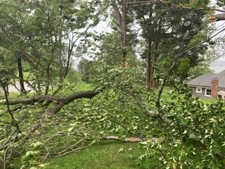
My brother took this picture in Center Island a short time ago
-
2
-
-
2 minutes ago, eduggs said:
Eerily calm right now. Like 5 kts or less.
That passed through my area at about 1pm.
-
I am posting the 1PM Obs from Mount Holly. This is going to be representative of the weather of the next 2-3 hours in the NYC area. I am highlighted the calm winds at the observing stations in Bucks Cty near me where the center was at that time.
REGIONAL WEATHER ROUNDUP
NATIONAL WEATHER SERVICE MOUNT HOLLY NJ
100 PM EDT TUE AUG 04 2020
NOTE: "FAIR" INDICATES FEW OR NO CLOUDS BELOW 12,000 FEET WITH NO
SIGNIFICANT WEATHER AND/OR OBSTRUCTIONS TO VISIBILITY.
* = STATION DOES NOT REPORT PRECIPITATION (E.G. RAIN, SNOW, ETC.)
OR FOG.
NJZ015>026-041800-
SOUTHERN NEW JERSEY
CITY SKY/WX TMP DP RH WIND PRES REMARKS
POMONA CLOUDY 77 71 82 S17G31 29.48F
WILDWOOD* N/A N/A N/A N/A MISG N/A
MILLVILLE CLOUDY 73 65 75 W35G54 29.59R
WRIGHTSTOWN LGT RAIN 70 70 100 SE17G29 29.45F
TRENTON HVY RAIN 71 70 96 S20G31 29.45F VSB 1
$$
NJZ001>014-041800-
NORTHERN NEW JERSEY
CITY SKY/WX TMP DP RH WIND PRES REMARKS
SUSSEX HVY RAIN 73 71 93 NE12G23 29.56F VSB 1/2
ANDOVER* N/A 75 71 87 VRB7G24 29.53F
MORRISTOWN RAIN 81 81 100 SE29G59 29.55F FOG HX 91
NEWARK HVY RAIN 74 73 97 SE29G48 29.51F FOG
TETERBORO RAIN 78 74 87 SE29G45 29.55F FOG
CALDWELL LGT RAIN 79 73 82 SE25G43 29.54F
SOMERVILLE LGT RAIN 74 71 91 SE14G38 29.46F FOG
ALLAIRE* CLOUDY 73 32 22 SE31G43 29.54F HAZE
TOMS RIVER* LGT RAIN 71 69 93 S23G37 29.49F FOG
$$
PAZ043-044-047-054-055-060>062-066>071-041800-
EASTERN PENNSYLVANIA
CITY SKY/WX TMP DP RH WIND PRES REMARKS
PHILADELPHIA LGT RAIN 73 68 84 W26G43 29.49R
NORTH PHILA CLOUDY 71 71 100 S8G20 29.44F
BLUE BELL* LGT RAIN 71 71 98 SW15G26 29.45F FOG
DOYLESTOWN LGT RAIN 72 69 90 VRB6 29.44F
QUAKERTOWN* PTSUNNY 72 72 100 CALM 29.46F FOG
PERKASIE* LGT RAIN 70 70 100 SE3 29.46F
POTTSTOWN LGT RAIN 67 64 90 NW20G38 29.53R FOG
LANCASTER LGT RAIN 67 64 90 N17G26 29.62F
COATESVILLE HVY RAIN 66 66 100 NW26G40 29.61R
WEST CHESTER LGT RAIN 68 64 88 NW18G41 29.53R
READING HVY RAIN 68 67 96 N24G37 29.58F
ALLENTOWN HVY RAIN 69 67 93 N26G39 29.47F VSB 1
QN CITY/ALNTWN HVY RAIN 68 68 100 NW24G36 29.48F
MOUNT POCONO HVY RAIN 64 63 96 NW18G26 29.63F VSB 1
HAZLETON HVY RAIN 64 63 94 NW10G20 29.76F
LEHIGHTON HVY RAIN 68 68 100 NW14G26 29.60F VSB 1
WILKES BARRE HVY RAIN 69 66 90 N12G20 29.72F FOG
$$
DEZALL-MDZ008-012-015-019-020-041800-
DELAWARE AND EASTERN MARYLAND
CITY SKY/WX TMP DP RH WIND PRES REMARKS
WILMINGTON LGT RAIN 71 64 78 NW28G46 29.59R
DOVER CLOUDY 73 68 83 SW18G36 29.71R
CHESWOLD MOSUNNY 72 68 88 W18G25 29.70R
GEORGETOWN PTSUNNY 77 68 73 W14G28 29.80R
EASTON PTSUNNY 77 70 78 W12G24 29.82R
STEVENSVILLE PTSUNNY 77 72 83 W16G26 29.78R
ABERDEEN CLOUDY 72 68 88 W13G20 29.70
PATUXENT PTSUNNY 82 73 74 W21G26 29.83
OCEAN CITY CLOUDY 79 68 69 W16G28 29.84R
WALLOPS ISLAND PTSUNNY 81 70 69 W13G25 29.86R
SALISBURY PTSUNNY 81 68 64 W17G26 29.83R
$$
PAZ001-021-NYZ056-072-MDZ011-DCZ001-041800-
OTHER NEARBY LOCATIONS
CITY SKY/WX TMP DP RH WIND PRES REMARKS
HARRISBURG PTSUNNY 74 68 81 NW15G26 29.69S
STATE COLLEGE PTSUNNY 72 68 88 NE7 29.81F
WILLIAMSPORT LGT RAIN 70 67 90 W8 29.73F
BINGHAMTON RAIN 66 65 96 E10 29.86F FOG
NEW YORK CITY LGT RAIN 76 73 91 SE21G43 29.60 FOG
BALTIMORE PTSUNNY 77 69 76 W15 29.75R
WASHINGTON DC PTSUNNY 78 69 73 W15G23 29.80R -
Winds have now switched over to the west and north west as the calm center moves away.
Pockets damaging wind-power outage potential 4P-10P Sunday Nov 15, 2020
in New York City Metro
Posted
Highest wind gust here is 30 mph in the past ten minutes. Wind gusts along the south shore of LI (Fire Island) currently gusting to 45 mph.