

Tatamy
-
Posts
2,031 -
Joined
-
Last visited
Content Type
Profiles
Blogs
Forums
American Weather
Media Demo
Store
Gallery
Posts posted by Tatamy
-
-
Still snowing here in Bethlehem Twp in Northampton Cty. 3 1/2” new. 24/23
-
3” OTG 24/23. Moderate snow 3/8 mile visibility.
-
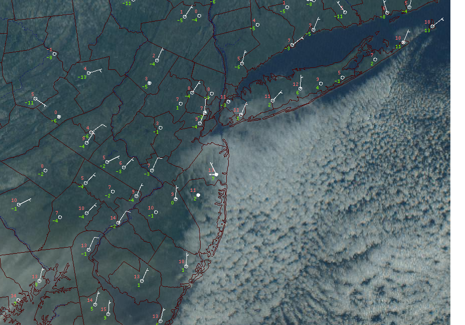
On radar it looks like the snow/ sleet line runs roughly along 202 in NJ and PA and then east between 22 and 287
-
7 minutes ago, lee59 said:
Yea I am in levittown about a 1/2 mile north of Hempstead Turnpike near the Wantagh Parkway. It is snow here but probably not for long. I looked at numerous observations south of the pike and they are like you near 36-37 degrees. I am 32.5.
It is my understanding that there is ice covering at least parts of Great South Bay. If that is true that might help you folks out on the island to hold on to the cold air for a little longer.
-
7 minutes ago, psv88 said:
For whatever reason images can’t attach …
Choose the size of the image and select small.
-
1 hour ago, wdrag said:
HRDPS impressive I80 north. watch it if Thunder snow gets going up here along the NYS-PA border. I like its colder scenario but I'll defer to the fact that I may in error. Am expecting snow thru midnight in Sussex County NJ and possibly back and forth mix rain/snow to S+ between 1A-3A.
I have moderate snow down here in Bethlehem Twp, PA with almost 1” new. Models have been dropping hints for days regarding the dynamics associated with this system. I would definitely agree that there is positive bust potential in the I80 corridor in NW NJ and NE PA. This is shaping up to be a very interesting night out here and places further north.

-
 2
2
-
-
-
2 minutes ago, wxman said:
Let us dream..............
I know- what could have been- but not this time…
-
The Coastal Front is set up from the Richmond area to near Dover, DE to about 10 miles NW of Atlantic City and then up along and west of the Garden State Pkwy along the Jersey shore and just south of the south shore of LI. This is the leading edge of the warm air at the surface that the powerful 850mb jet is going to force up to the north and west and change everyone over to rain (if you don’t start as rain). In the case of the Poconos and the I84 corridor this would be sleet and freezing rain. This is situated as projected by the models at this time.
-
3
-
-
-
Snowing in Reading, PA and the leading edge is just SW of Allentown. Snow is just beginning near the west side of Philadelphia.
-
7 minutes ago, Shades said:
Belmar NJ reporting snow on station OBS: ocean effect.
Not picking up well on radar, however.
I checked the webcam out there. Just the SC deck coming in off of the ocean. No flurries there at this time.
-
16 minutes ago, bluewave said:
While the 12z hi res Nam is still a little out of its best range, it has a similar look. One wild card for the wind gust potential is where the meso lows pop to the east of the main parent low. The hi res Nam is showing one wind maxima near the Jersey Shore to Western Long Island. Then another stronger one with meso low out near Eastern Long Island.


Was digging into the models and in looking at the HRRR from 12z it seems to be slightly less intense with the strength of the 850mb jet as compared to the NAM. The result is more snow in inland locations. The NAM has 1-2” vs 3-6” on the HRRR. Any thoughts on this?
-
31 minutes ago, jm1220 said:
I’d hoist high wind watches for LI/NYC for Monday if I was Upton. It’s becoming pretty clear this is a threat. Coastal flood watches as well.
How about Hurricane Force Wind Watches for the near shore and offshore waters as well.
-
4
-
 2
2
-
-
2 minutes ago, jm1220 said:
For sure. When you see a roaring SE mid level jet like models are showing, a lot of the snow maps on the SE edge are going to be overdone because you know the sleet line is going to explode northward. On the west side of the storm though there definitely will be an axis of heavy snow totals since those winds slow down and cause a region of quickly rising air where the deform axis forms. Unfortunately that’ll be way far west-if you believe the NAM it’ll be from E OH to Buffalo up into Canada.
Concerning how much of that jet is shown to mix down near the coast. If it coincides with high tides there could be some serious problems in vulnerable flooding spots since ESE winds will pile in lots of water.
Very true. The upside of this is that this won’t last over multiple tidal cycles. If it did it would be a much more serious issue. For coastal areas I think that the biggest concern will be strong winds leading to power outages.
-
5 minutes ago, jm1220 said:
NAM can be overdone with the mid level warmth but it’s usually closer to reality than the globals.
My rule of thumb has been if we are dealing with a potential winter storm that you think can bring mixing / taint issues then you want to see a mid level jet from a warm source region of at least 20 - 30 mph to ensure that changeover happens. I will be the first to admit that this is a general statement and is oversimplifying the atmospheric processes involved however I seen this play out time and again. In any case the 850mb jet we are seeing will be from the SE at up to 90 mph for a few hours Monday morning.
-
1
-
-
1 minute ago, jm1220 said:
NAM is so warm in the mid levels that it switches almost the whole state of PA to an ice storm. I have to think that’s a little extreme but goes to show that anyone in our area that starts as snow, it’ll be quite brief.
I saw that graphic a short time ago as well. Folks in the western part of the state have been progged to get a big dumping on the models and still are on the globals. The NAM doesn’t play favorites does it??
-
1
-
-
47 minutes ago, NittanyWx said:
Unless things change drastically everyone is changing over within 3 hours of precip onset. It is a very, very brief window it can snow here before the column warms. GFS this AM has the 0C 850 isotherm north of 287 by between 11pm and 12 AM Monday.
You'd need the entire mid-level low structure shifted about 150-200 miles to make this work.
I am in eastern PA, 80 miles west of NYC. I am figuring on 2-3 hours of snow then a quick flip to sleet/ice/rain in that order. That 850mb jet means business and the NAM / RGEM seems to be leading the way with this feature. As depicted that jet will be whistling over our heads at Cat 2 hurricane strength early Monday morning. The source region will be from out over the Atlantic so it won’t be bringing cold air with it either.
-
1
-
-
1 minute ago, eduggs said:
That's true. But I wasn't even thinking of mountain tops... I was more thinking of towns on or near highways. The town of Hunter is approx. 2000ft asl and a great place for easterly-flow coastals. That's why it's my first choice. But the area near Mt. Pocono is right off I-80 and a little closer, although only about 1200ft or so. Right now you'd have to go out to central or western PA to get into any kind of deform. So Catskills are probably the better choice.
I was thinking of the ski resort at Hunter Mtn. which is much higher. KMPO where the airport observing site is at 1886ft (from the Mt. Holly website). The town itself is a couple of hundred feet lower.
-
16 minutes ago, NittanyWx said:
I am very interested in the timing of high tide vs LLJ cranking as this storm develops midweek for Jersey. Thankfully I believe that has the worst of the winds in between high tide, but subtle differences in timing could make for a pretty rough coastal flooding situation.
If there is an upside here the forward movement of the storm system is such that it is not likely to cause flooding through multiple tidal cycles.
-
3 minutes ago, sheahunter said:
Be careful with Hunter, this sort of setup screams lots of sleet, wind and with the warmth aloft maybe even worse. Seen it too many times
Your caution is well advised however the poster did not want to travel more than 100 miles from the NYC area. As others have noted this one definitely has the look of being mainly a snow producer for areas in central and western PA and NY state.
-
The 18z Euro has run. The overall presentation of expected snow amounts is similar however the 850mb low does track very slightly further west on this run.
-
1 hour ago, eduggs said:
Without thinking about it too much I'd vote eastern Catskills (e.g., Hunter) or Mt. Pocono, PA as a backup. Long drives though.
I would take Hunter over MPO in a heartbeat. Hunter is close to 4000’ above MSL while MPO is 2000’. Track will be key of course.
-
1
-
-
1 minute ago, mikem81 said:
Quick Poll:
If I am taking my kids somewhere on Sunday Night/Monday to see good snows; what is best within 100 miles of NYC?
Catskills
-
2
-


OBS-NOWCAST for a multi impact main event 4PM today - 8A Monday Jan 16-17, 2022 with post storm minor snow accumulations possible Noon-Midnight Monday evening.
in New York City Metro
Posted
Precip has changed over to a mix of sleet/snow/freezing rain. Snow total 3 1/2”. 25/24