

Tatamy
-
Posts
2,032 -
Joined
-
Last visited
Content Type
Profiles
Blogs
Forums
American Weather
Media Demo
Store
Gallery
Posts posted by Tatamy
-
-
6 minutes ago, Poker2015 said:
Exactly, half of the people in here would get shafted with that track...We would get some, but would be a pretty boring storm for western NJ.
I would have received 3” at 12z and I would still get that on this run. You can’t make this up…
-
 1
1
-
-
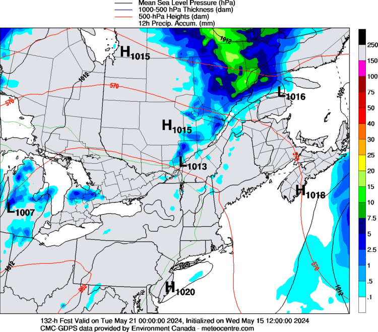
CMC at 132 hrs
-
 1
1
-
-
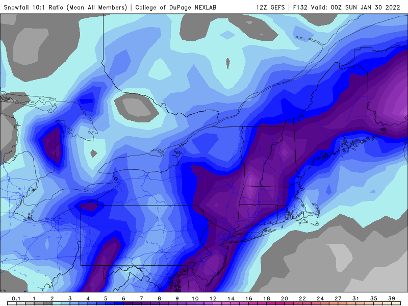
12z GEFS
-
2
-
 1
1
-
-
20 minutes ago, tamarack said:
CAR recorded 957 in 2/2/76 and I think the OV bomb of Jan 78 got down to about 952. What was 1938's deepest in New England? (Or at LI landfall?)
2/2/76 reached down to 970 mb at my location at the time on the north shore of LI.
-
1
-
-
-
Very light snow 31 degrees; visibility 5 miles.
-
Light snow is moving east through eastern sections of PA at this time. I am seeing visibilities in the range of a mile or so to the west of Allentown at this time.
-
3 minutes ago, eduggs said:
I just checked the EPS. Very few of the individuals get precip. back to us or especially further west. Even the ones where the SLP makes a close pass are pretty limited on the western side. That's what happens if the trof develops late... which is where this looks to be heading. Eastern SNE can pull it off, but we need an explosive trof.
Ironically the one EPS member that tilted earlier ended up taking the same track as last weekend that deformed in Ontario.
On the 12z GEFS, out of 20 members, one hits the whole area, another is an inland runner, another clips the east end of LI, and the remainder bring minimal or nothing.
-
2
-
-
1 minute ago, MJO812 said:
Bias in play?
I'm still waiting for my snow this weekend
Look at 500mb - no bueno - trough is flatter.
-
 1
1
-
-
15 minutes ago, eduggs said:
The CMC might be the best model run of the winter so far. Snow would start late Friday night and continue for almost 24 hours! Weekend snow! Very heavy snow with major accumulations region-wide. Blizzard conditions probably on LI. It stays cold with a follow-up 2-4" on Monday with an inverted trof associated with a late developing coastal low. Wow what a weenie run!
My take is a miss east is favored here. The sharpness, amplitude, and orientation of the trof are very sensitive to minor changes. Eastern SNE seems to stand the best chance for significant precipitation. But seeing this huge solution means we're still in the game I think. Just gotta keep expectations in check.
I wouldn’t be getting sucked into this one too quickly… like you said it’s a nice thought.
-
2
-
-
1 minute ago, MJO812 said:


If this works out we are looking at 2-4” across the area Tuesday night.
-
-
-
10 minutes ago, Northof78 said:
I think this will be the bigger storm over the next week, looks like a nice 2 - 4" for most...other looks offshore
That is very possible. There is actually a lot of support from the 12z mesos for the amounts you noted. With all the focus on the Friday night system and whether or not it goes OTS or not I will take what we can get from this one.
-
44 minutes ago, LibertyBell said:
NAM is pretty underrated, especially when it comes to the big ones.
It's like that HR hitter that usually strikes out but somehow bring him up in the bottom of the ninth with two outs and he hits HRs lol.
Those are truly rare....most strike out HR hitters strike out in the clutch way more than they usually do. The only one I can think of off the top of my head who was the opposite of that is Reggie Jackson.
So the NAM is the Reggie Jackson of weather models lol.
The NAM just managed to draw a walk with the last event. It consistently over did mid level warming in my area and was way under with snowfall estimates. This time around it was the HRRR/RAP FTW. It did do okay in the coastal areas.
-
17 minutes ago, LibertyBell said:
How heavy is it up by Albrightsville-Lake Harmony area?
This type of snow activity tends to be low topped and the activity up in the Poconos is not always well picked up by radar from Mt. Holly. I can’t tell you what the conditions are like up there now however in the space of 5 minutes we went from 3/8 mile visibility to just a few flurries. I would guess that conditions are improving up there.
-
1
-
-
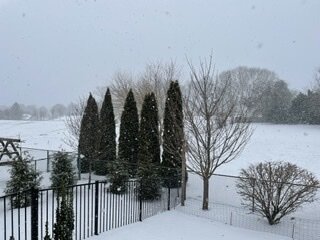
This is what conditions are like at my location currently.
-
5
-
2
-
-
5 minutes ago, SnoSki14 said:
Pretty impressive streamer in western NJ
Mt. Holly has a special weather statement for this feature indicating the potential for 1/2” to 1” of accumulation for the area extending from the Lehigh Valley across central NJ down to the area of Toms River, NJ.
-
2
-
1
-
-
A lake effect streamer has set up shop over eastern PA and far western NJ. Have been seeing some light snow and flurries around for a couple of hours now.
-
3
-
-
0z NAM continues to be in for the Thursday 1/20 anafront event.
-
3
-
-
48 minutes ago, LibertyBell said:
Hey how much fell there and up by where I live? I'll be going there next week and I wonder if I need to hire a snow plow guy. The last one I had dented my garage with his plow. He said there was so much snow he couldn't see where my garage was.
I received 3.7” here. I would recommend you arrange for a plow guy. There was probably in the range of 6” where you are.
-
1
-
-
26 minutes ago, North and West said:
As I was shoveling out slush today, I reminded myself I loved this when I was younger and that my kids do, too.
.I had to remind myself of that as well when I was doing my shoveling. I had to put down two bags of ice melt as well as the predicted warmer temperatures for the overnight period never came to be. We had plenty of rain though but the ice held up just fine. And to think that a lot of people lamented getting no snow or very little last night. Oh well. It looks like those who did not see snow of any significance last night will get their chance as we go through the week.
-
1
-
-
18 minutes ago, North and West said:

.With the Kuchera ratio applied this would be 10 - 18” across the area. In addition, FWIW, the Ukmet is buying into the Ana frontal event for Thursday.
-
2
-
-
3 hours ago, wdrag said:
By the way: Not sure anyone has noticed, and I stand corrected, but no coastal flooding NJ Coast to sw side of LI as far as i can tell. Wind shifted and lessened prior to high tide and not enough duration of gale force winds. We are at high tide now... there could be some pockets of minor in there but overall at the standard tide stations used prior to 2018, no flooding as far as i can tell.
Max wind at airports that I saw was ~57MPH at JFK - 250AM, with many reports in the of gusts in the 50-58 MPH range for LI. I se the Blue wave report above and I did not check marine platforms. Back midday with CoCoRaHs assessment of snowfall and qpf.
SE Light at Block Island gusted to 72 mph at 5:49 am. Another nearby station on Block Island gusted to 71 mph at about the same time. The stations that I follow on Fire Island gusted to between 40-45 mph overnight.
-
1
-


January 28-30th Possible Nor'easter
in New York City Metro
Posted
06z NAM at the end of its range is flatter and holds back energy in the SW.