nj2va
-
Posts
15,345 -
Joined
-
Last visited
Content Type
Profiles
Blogs
Forums
American Weather
Media Demo
Store
Gallery
Everything posted by nj2va
-
But February is sun angle season
-

Jan 24-26 Weekend Snow and Sleetfest Model Thread Part Tres
nj2va replied to H2O's topic in Mid Atlantic
Putting the NAMs to the side, it seems most guidance that I’ve seen (Euro, GFS, 18z HRRR, etc), suggests we flip between 14-15z with anywhere from 0.5-0.6” QPF by then. That’s a nice thump IMO. Even if we flip 13-14z, that’s still 0.5” QPF on the Euro. -
January 24-26: Miracle or Mirage JV/Banter Thread!
nj2va replied to SnowenOutThere's topic in Mid Atlantic
If we were staring at a 8-15” snowfall a few days ago and it morphed into a rainstorm 96 hours later, sure I’d get the gnashing of teeth. But this is going to be a high impact event of snow/sleet/freezing rain with temps in the teens/20s. We don’t get these events around here for a reason - we’re not interior New England lol -
January 24-26: Miracle or Mirage JV/Banter Thread!
nj2va replied to SnowenOutThere's topic in Mid Atlantic
Since you can tell the future, can you let me know the powerball numbers? -
January 24-26: Miracle or Mirage JV/Banter Thread!
nj2va replied to SnowenOutThere's topic in Mid Atlantic
Every. Fucking. Event. -
Jan 24-26 Weekend Snow and Sleetfest Model Thread Part Tres
nj2va replied to H2O's topic in Mid Atlantic
Looks like about a 15z flip for DC on the GFS..assuming that we usually flip earlier than modeled (just like WAA precip starts earlier than modeled), its still a nice thump and I liked seeing it add ~0.1” QPF over 6z. Still like my 6-10”. Not sure why there’s such doom and gloom, it’s not like we’re staring down a rainstorm now. -
Jan 24-26 Weekend Snow and Sleetfest Model Thread Part Tres
nj2va replied to H2O's topic in Mid Atlantic
GFS is a bit more QPF in the thump over 6z. About 0.1” more in DC at H27. Waiting for sounding to come in to see when we’d flip but 0.7” QPF by 15z in DC. -
Low of 11 here and -8 at Deep Creek. It’s so nice not sweating high temps today.
-
January 24-26: Miracle or Mirage JV/Banter Thread!
nj2va replied to SnowenOutThere's topic in Mid Atlantic
Coffee in my favorite mug in honor of our storm -
January 24-26: Miracle or Mirage JV/Banter Thread!
nj2va replied to SnowenOutThere's topic in Mid Atlantic
Heading to the gym then going to the grocery store - I must be a glutton for punishment. I’m sure they’ll have one onion, a half eaten piece of bread, and a carton of heavy cream left. -
January 24-26: Miracle or Mirage JV/Banter Thread!
nj2va replied to SnowenOutThere's topic in Mid Atlantic
We spent NYE at the Mt Washington hotel last year. Such a beautiful area up there, thankfully it wasn’t quite that cold -
Jan 24-26 Weekend Snow and Sleetfest Model Thread Part Tres
nj2va replied to H2O's topic in Mid Atlantic
11/-9 and a whopping -7/-12 at Deep Creek. Euro was a beaut to wake up to. -
Jan 24-26 Weekend Snow and Sleetfest Model Thread Part Tres
nj2va replied to H2O's topic in Mid Atlantic
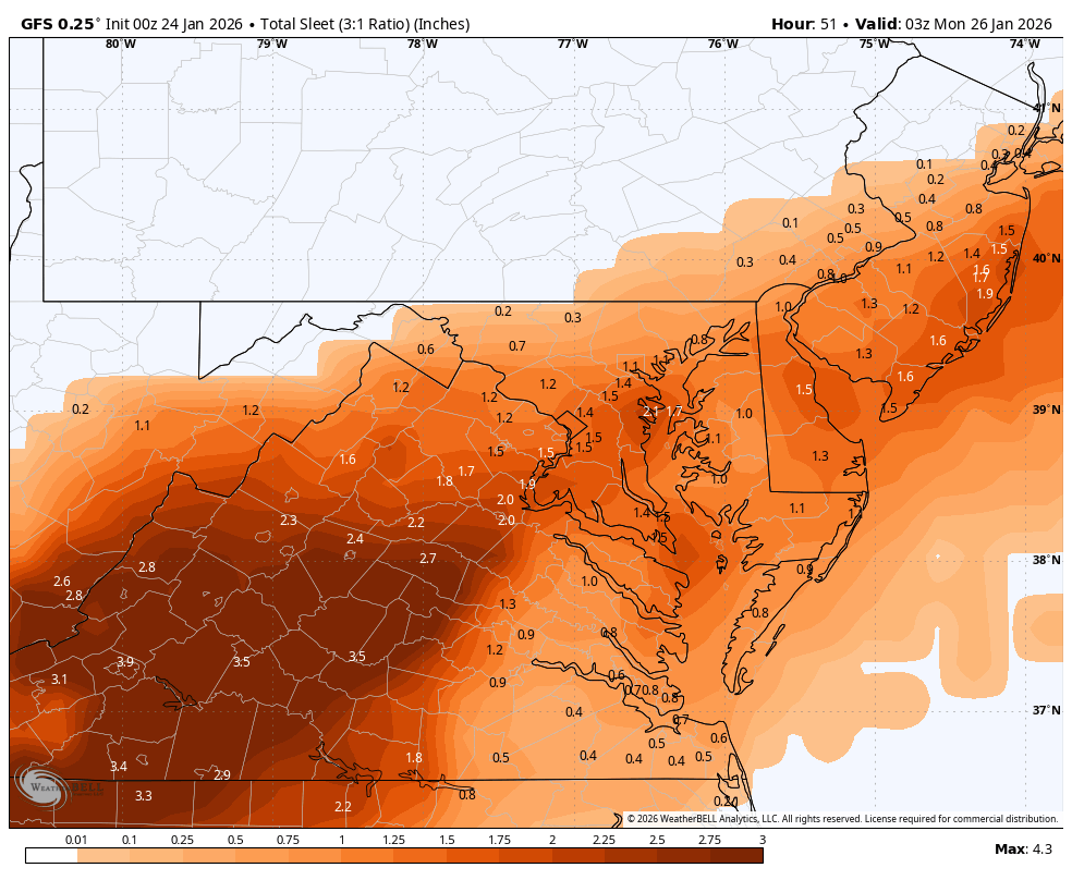
Latest map
-
18/-8 here -4/-8 Deep Creek
-
Jan 24-26 Weekend Snow and Sleetfest Model Thread Part Tres
nj2va replied to H2O's topic in Mid Atlantic
That Euro run is a thing of beauty for DC. Soundings suggest DC holds on until about 17z Sunday - and about 0.9” QPF has fallen already. LFG -
Jan 24-26 Weekend Snow and Sleetfest Model Thread Part Tres
nj2va replied to H2O's topic in Mid Atlantic
If that carries eastward, it would remove the lone model that’s really punching the mid level warmth way quicker/north than others. I know I’ll flip but a few extra hours will make a big difference. -
Jan 24-26 Weekend Snow and Sleetfest Model Thread Part Tres
nj2va replied to H2O's topic in Mid Atlantic
20/-3, damn its cold -
Jan 24-26 Weekend Snow and Sleetfest Model Thread Part Tres
nj2va replied to H2O's topic in Mid Atlantic
Pivotal has it -
At this point, we should just close the other thread and have this be the main thread.
-
January 24-26: Miracle or Mirage JV/Banter Thread!
nj2va replied to SnowenOutThere's topic in Mid Atlantic
Heyyooo! Ovi ENG and a Caps win! -
Jan 24-26 Weekend Snow and Sleetfest Model Thread Part Tres
nj2va replied to H2O's topic in Mid Atlantic
Unless the NAMs stay stubborn tomorrow, I’m feeling good for a 6” floor for DC based on tonight’s globals. -
Jan 24-26 Weekend Snow and Sleetfest Model Thread Part Tres
nj2va replied to H2O's topic in Mid Atlantic
Honestly, I’ve been so busy at work I haven’t paid much attention during the day. A quick look vs 18z and the flip was a touch later than 18z. I honestly don’t really put much confidence in UK thermals but a nice data point for the better lol -
Jan 24-26 Weekend Snow and Sleetfest Model Thread Part Tres
nj2va replied to H2O's topic in Mid Atlantic
UK would be fun, flips DC basically at 17/18z Sunday with ~0.9” QPF before that. -
January 24-26: Miracle or Mirage JV/Banter Thread!
nj2va replied to SnowenOutThere's topic in Mid Atlantic
Boom, Tommy with the assist on the Pro goal! -
Jan 24-26 Weekend Snow and Sleetfest Model Thread Part Tres
nj2va replied to H2O's topic in Mid Atlantic