

nj2va
-
Posts
15,345 -
Joined
-
Last visited
Content Type
Profiles
Blogs
Forums
American Weather
Media Demo
Store
Gallery
Everything posted by nj2va
-
First flakes in Beverley Hills neighborhood of Alexandria!
-
My guess is first flakes here in next 30 minutes. Virga overhead Alexandria right now.
-
Virga pushing north into Fairfax County. We’re close.
-
Snowing at Wisp on the cameras.
-

January 24-26: Miracle or Mirage JV/Banter Thread!
nj2va replied to SnowenOutThere's topic in Mid Atlantic
Omg the guy did it…scaled to the top of Taipei 101 -
Enjoy it!
-
DP is slowly creeping up. 19/-2.9
-
January 24-26: Miracle or Mirage JV/Banter Thread!
nj2va replied to SnowenOutThere's topic in Mid Atlantic
Was it the Blue Dog bakery treats that did the trick? -
This looks like something from Stranger Things
-
January 24-26: Miracle or Mirage JV/Banter Thread!
nj2va replied to SnowenOutThere's topic in Mid Atlantic
Yeah, honestly can’t believe he’s doing this. He’s about 40 minutes into the climb. -
We keep ours up (without ornaments) there until the end of winter. Really goes well with the season and snow there. Enjoy!
-
January 24-26: Miracle or Mirage JV/Banter Thread!
nj2va replied to SnowenOutThere's topic in Mid Atlantic
I’m nervous just sitting on the couch watching Skyscraper on Netflix. -
19/-3
-
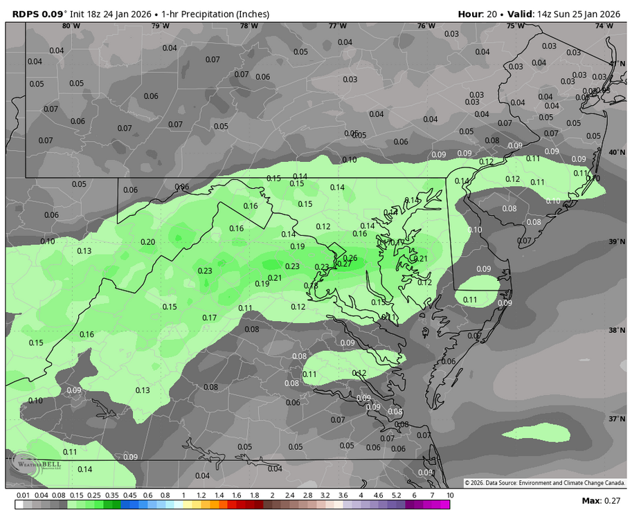
This is the 1 hour precip right before DC flips - epic Jebwalk in that hour.
-
January 24-26: Miracle or Mirage JV/Banter Thread!
nj2va replied to SnowenOutThere's topic in Mid Atlantic
I got flurries on the Ring cameras there, #firstflakes -
Yeah, sorry. Just google MD PA VA map and there’s a ton that come up.
-
-
Excellent! Steadily marching north.
-
20/-3, feels like snow!
-
January 24-26: Miracle or Mirage JV/Banter Thread!
nj2va replied to SnowenOutThere's topic in Mid Atlantic
Heading to 5p Mass and then will be enjoying an espresso martini. Cheers to the storm! -
Seems ahead of schedule?
-
21/-5 - overcast with clouds streaming in.
-
Jan 24-26 Weekend Snow and Sleetfest Model Thread Part Tres
nj2va replied to H2O's topic in Mid Atlantic
12k flips DC at 12z with a little more than 0.4” QPF all snow. 3k at 12z - DC is just barely all snow but it charges north of the city by 13z. About 0.35” of all snow on the 3K…shaved a few hundredths from 12z. -
Oh for sure, just getting ready for the complaining.
-
January 24-26: Miracle or Mirage JV/Banter Thread!
nj2va replied to SnowenOutThere's topic in Mid Atlantic
I just topped my Birdfy feeder but have an extra bag — feel free to stop by to take it


