SnowNiner
-
Posts
1,907 -
Joined
-
Last visited
Content Type
Profiles
Blogs
Forums
American Weather
Media Demo
Store
Gallery
Everything posted by SnowNiner
-
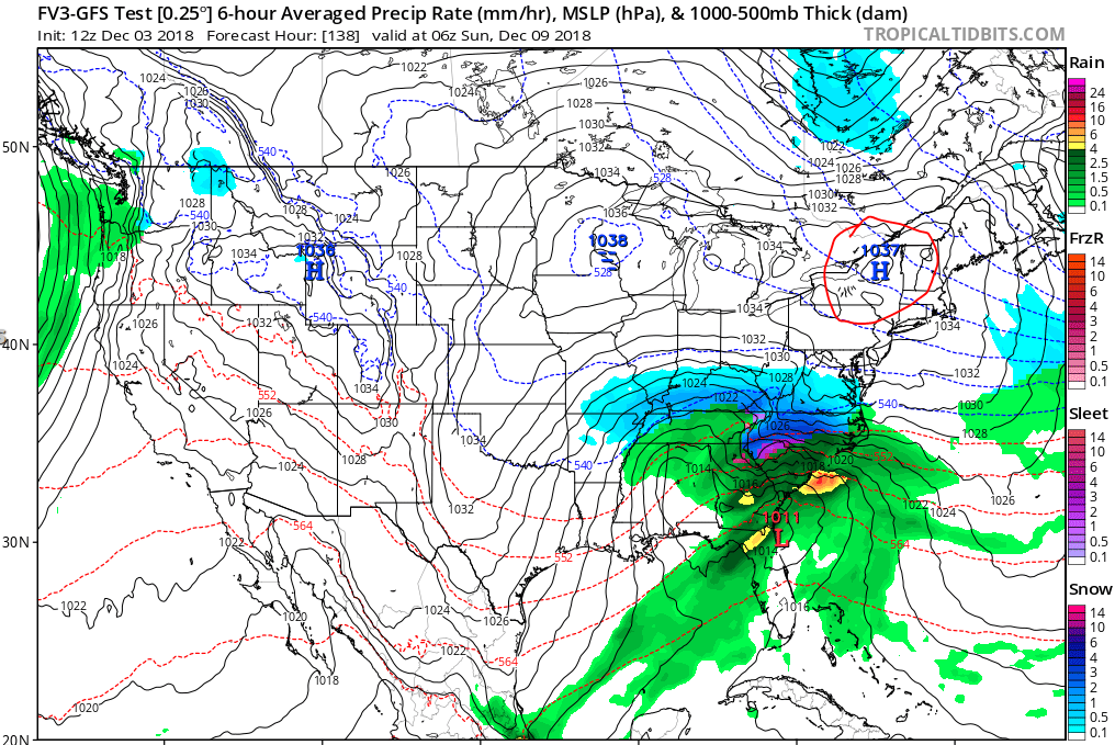
this looks pretty good to me...need that high though to keep moving east with the low and dig in.
-
Huge Euro run incoming. Can't have FV3/GFS be the only colder more suppressed model.
-
FV3 on its own then with the colder solution of the storm throughout. Hopefully the EURO will join to add weight. I'd really like the UKMET to trend colder there...as well.
-
Ok, even I can't weenie out that much. I can't even with that. CLT would bet counting snow in feet, not inches. lol. Gonna have that save that one though for fun!
-
What's the key in getting that high to pop in the NE? Some modeling is showing only the midwest high, and some like the EURO and FV3 pop the high in the perfect placement. What synoptically needs to happen for that to occur?

-
Hopefully it ticked colder and lower dew points as well.
-
Good track, but not cold enough. I want to see the the 850s south of Rock Hill at least.
-
Thanks! Yeah, saw the FV3, which was a cold, cold run with lots of snow for everybody. NWS also favored the 0Z Euro, which was colder than the EPS so we've got that. Hopefully we can trend back to a more suppressed Miller A track slider. I need the afternoon runs, like right now.
-
Yeah, we need to see this trend colder for sure. 850s shown below won't cut it. What feature do we need to look for to get this colder in upcoming afternoon runs? I heard we lost the Ukie too? Haven't seen specifics. Sounds like bad trends overnight.
-
Did notice the EPS and GEFS back off on the cold temps a bit last night. EPS snow mean backed way off. Clown maps are nice, but I'd like to see this thing stay south and trend colder as we get closer.
-
Charlotte is always, always the transition zone between snow/sleet or sleet/freezing rain/rain, much like Raleigh. I think they poured I85 there based on synoptic meteorology. I hope though with the very nice CAD that is being advertised, we get closer to the FV3 temps, I think it's possible. This thing has the potential with the qpf and set up to be a historic storm. Amazing we've still got 5/6 days to go. This has been on our radar for almost a week now.
-
Well, right now I think it's just noise. At this point we just check the ensembles and if they still look nice and suppressed along the coast we're good. At day 3 that's when I'll probably be looking very closely at each operational run.
-
Just catching up with the models today. WOW! I'm a little taken back. Again, I've only been on the boards and looking at models for about 8 years now. I've yet to see what's being modeled so consistently for my back yard. The ensembles have such a nice damming signature (strong) through the storm now. Thank you all for the great play by play and break down. I remember the same think about Eric Thomas. He went on air several days early and pretty much said, Charlotte is going to get nailed by a big winter storm. And he was right. If I recall, that was also an El-nino year with a southern wave. They seem pretty comparable.
-
Thank you Grit for your analysis through tracking this event. I've learned alot and it's been very helpful. Hard not to get an increased excitement level. Yes, we've had massive busts in the past. But with both the GEFS and EPS showing a nice storm, and all their operationals on board (currently), you've got to feel good about it. In addition, NWS is noticing the threat and are starting to highlight it (which I found is rare this far out). But I've only been on the boards and following the models since about 2010. So yes, there's lots of time for things to crap out. It could completely unfold, crash and burn. Considering the nino, stj energy and the other favorable synoptic elements in place though it just feels good. I've always thought the good ones you can see at long leads. This seems like a good one. Let's see where it goes.
-
That seems a bit overdone IMO. I may be wrong but I think Brad P's forecast of 4-8 is more reasonable for CLT. Lines up with GFS products. I'll need to check but I don't know if any models showed a foot of rain for CLT yet?
-
Evidently. Overall this thing has been a bit overhyped IMO, from evacuating the entire SC coast 2 days ago to this. The charlotte observer is telling everybody on the front page for everybody to be prepared to be without power for 3 days. I'm just not seeing it for clt. Yes, there's going to be alot of rain (maybe). And if you live in a floodplain, there's going to be flooding (could be). I'm not sure power outages are going to be widespread even if there is alot of rain. So why cancel schools....before it even reaches Charlotte? Facebook recommendations seem out of control too from what I hear from my workmates.
-
Howdy all, interesting weather in the summer, go figure! I'm really not a tropical guy and I don't really follow weather very closely in the summer. But I usually pay attention to tropical storms tracking toward the Carolinas. I've never seen a storm that I recall come up SC/NC and go NW (other than Hugo). 98% of the storms re-curve more toward the north and NE. If I had to bet, I'd say this one will do similar. Though we hug the EURO in the winter, I'm leaning toward this affecting the Eastern Carolinas more as usual. I'd be surprised if Charlotte north and west had any extraordinary weather. With that said, considering we've got another 3 days before landfall I bet the final track is totally different than what we're seeing. The last 2 years have shown these systems go where they want to go and we're not that great in predicting them yet at long leads.
-
I'm sure I'll get some light accumulations for the next few hours, but it's going to be light due to temps above freezing. That 5 inches ain't happening. This line is moving quick too, hopefully this will slow down and pivot.
-
I'm not so sure. I'll be happy with 2 inches at this point. Temps are ALWAYS a problem.
-
Every model I've seen has Raleigh and eastern/central NC in the sweet spot. Hey but if you want to give me more snow, I'll take it! I am concerned with the continued forecast for rain/snow at the onset by my NWS.
-
This isn't really a wnc storm. It's a eastern NC special, the late tilting trough and lack of a gulf storm, Charlotte is right on the fringe...imo
-
"Boom" completely overused so far this year. Very inappropriate. Bad form. Burger would be so upset. So we do know the 18z GFS is going to crush all our dreams this run right?
-
Are we still tracking the beach flurries? I'd much rather focus on our torrential cold rain cutter on the 8th.
-
Meh, we rain, we toss. Looks like a cutter. Banter ftw
-

The December to Remember 7th-8th blue turd winter threat thread.
SnowNiner replied to lilj4425's topic in Southeastern States
Thank you Grit for your analysis and play by play for this event, and others. It's been educational. Same goes out to Buddy, Wow, and all the others who have a nice knowledge and interpretation ability of the models. I too have been looking at the soundings of the RAP, HRRR, and NAM3 and even though it shows CLT in the green, the soundings show that pretty much the whole column is below freezing other than right near the surface. Although I know we're not going to accumulate I'm still rooting to see some snow falling from the sky tomorrow evening and night. But again, it's absolutely amazing the difference between Charlotte, and anywhere north and west of here. Charlotte/85 is ALWAYS the battleground. Excited to get into Iredell county next year. Hopefully the battleground doesn't move north with me.